File:2008 Sichuan Earthquake aftershockes through May 28.pdf

此PDF文件的JPG预览的大小:463 × 599像素。 其他分辨率:185 × 240像素 | 371 × 480像素 | 593 × 768像素 | 1,275 × 1,650像素。
原始文件 (1,275 × 1,650像素,文件大小:1.29 MB,MIME类型:application/pdf)
摘要
| 描述 |
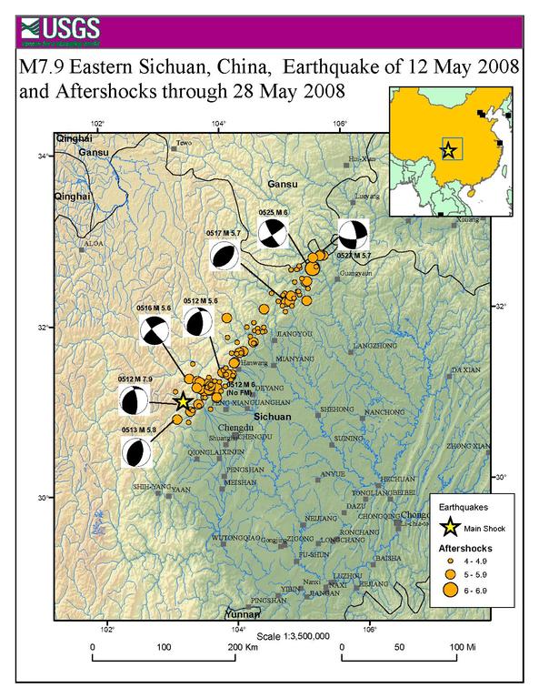
English: Map showing the location of the 2008 Sichuan earthquake and all the aftershocks following it through May 28, 2008 |
| 日期 | |
| 来源 | USGS |
| 作者 | USGS |
| 授权 (二次使用本文件) |
Public Domain |
许可协议
|
|
原始上传日志
原始描述頁面位於這裡。下列使用者名稱均來自en.wikipedia。
- 2008-06-09 20:51 Cyclonebiskit 1275×1650× (1352464 bytes) {{Information |Description=Map showing the location of the 2008 Sichuan eathquake and all the aftershocks following it through May 28, 2008 |Source=[https://earthquake.usgs.gov/eqcenter/eqinthenews/2008/us2008ryan/#summary USGS] |Date=2008-6-1 |Author=USGS
文件历史
点击某个日期/时间查看对应时刻的文件。
| 日期/时间 | 缩略图 | 大小 | 用户 | 备注 | |
|---|---|---|---|---|---|
| 当前 | 2014年4月13日 (日) 21:55 |  | 1,275 × 1,650(1.29 MB) | The Bushranger | Transferred from en.wikipedia |
文件用途
以下页面使用本文件:
全域文件用途
以下其他wiki使用此文件:
- en.wikipedia.org上的用途
- fi.wikipedia.org上的用途
- id.wikipedia.org上的用途
- mt.wikipedia.org上的用途
- sh.wikipedia.org上的用途
- sl.wikipedia.org上的用途