File:Bahn-Streckenkarte Deutschland-06-2010.png

原始文件 (1,122 × 1,515像素,文件大小:680 KB,MIME类型:image/png)
| 描述 |
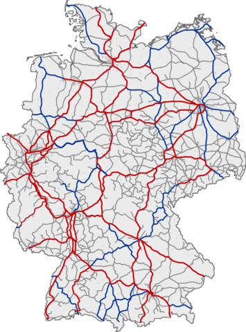
Deutsch: Eisenbahnnetz in Deutschland. Rot: ICE-Strecken; blau: IC/EC-Strecken; grau: sonstiger Personenverkehr
English: Railway network of Germany. Red: lines with InterCityExpress traffic; blue: lines with InterCity/EuroCity traffic; grey: lines with other passenger traffic
Français : Réseau ferré allemand. Rouge : lignes InterCityExpress (ICE); bleu : lignes InterCity/EuroCity; gris : autres lignes de transport de passagers
Magyar: Németország vasúthálózata ;vörös :Vasútvonal InterCityExpress közlekedéssel ;kék :Vasútvonal InterCity/EuroCity közlekedéssel ;szürke :Vasútvonal egyéb személyvonat forgalommal |
|||
| 日期 | (UTC) | |||
| 来源 | ||||
| 作者 |
|
|||
| 其他版本 |
|


| 这是一张修改过的图片,这意味着它已在原版本的基础上通过软件进行了编辑,改动内容:Aktualisiert。其原始版本为:Bahn-Streckenkarte Deutschland.png。修改者:YouthOfSword。
|
This image was generated with OpenGeoDB. The information there is placed in the public domain, images generated from OpenGeoDB are derivative works without passing the threshold of creativity, they are therefore also public domain.
| 此作品不具有版权,属于公有领域,因为其所包含之内容均为公共财产且没有明确的原始作者信息。 如果此图片超出原创性门槛的话,那么作为版权所有者,允许基于以下条件使用该图片:
{{PD-ineligible}}
|
原始上传日志
This image was a derivative work of the following image:
- File:Bahn-Streckenkarte_Deutschland.png licensed with GFDL-OpenGeoDB, PD-ineligible
- 2006-05-02T01:06:28Z Qualle 1122x1515 (215324 Bytes) {{Information| |Description={{de|Eisenbahnnetz in Deutschland ;rot :ICE-Strecken ;blau :IC/EC-Strecken ;grau :sonstiger Personenverkehr}}{{en|Railway network of Germany ;red :lines with InterCityExpress traffic ;blue :lines w
Uploaded with derivativeFX
In order to reestablish file version continuity for those who still link to the older file File:Bahn-Streckenkarte_Deutschland.png, on February 16, 2011, the current version of this file has been uploaded as current version of File:Bahn-Streckenkarte_Deutschland.png to its location in Wikimedia Commons. --Qniemiec (talk) 02:16, 16 February 2011 (UTC)
文件历史
点击某个日期/时间查看对应时刻的文件。
| 日期/时间 | 缩略图 | 大小 | 用户 | 备注 | |
|---|---|---|---|---|---|
| 当前 | 2010年6月6日 (日) 11:58 | | 1,122 × 1,515(680 KB) | YouthOfSword | {{Information |Description={{de|Eisenbahnnetz in Deutschland ;rot :ICE-Strecken ;blau :IC/EC-Strecken ;grau :sonstiger Personenverkehr }} <br /> {{en|Railway network of Germany ;red :lines with InterCityExpress traffic ;blue :lines with InterCity/EuroCity |
文件用途
以下页面使用本文件:
全域文件用途
以下其他wiki使用此文件:
- de.wikipedia.org上的用途
- en.wikipedia.org上的用途
- fr.wiktionary.org上的用途
- ja.wikipedia.org上的用途