File:BaytJibrin.jpg

本预览的尺寸:800 × 459像素。 其他分辨率:320 × 183像素 | 640 × 367像素 | 900 × 516像素。
原始文件 (900 × 516像素,文件大小:101 KB,MIME类型:image/jpeg)
摘要
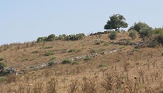
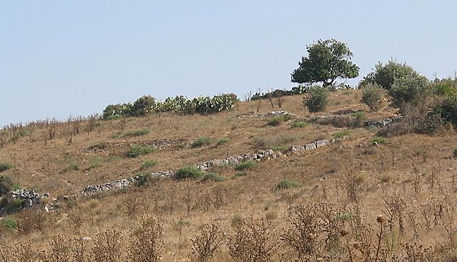
| 描述 | The ruins of Bayt Jibrin, 2005 |
| 日期 | 2005年8月1日 (原始上传日期) |
| 来源 | 无法识别来源。根据版权声明推断为其自己的作品。 |
| 作者 | 无法识别作者。根据版权声明推断作者为Zero0000。 |
许可协议
Zero0000,本作品著作权人,特此采用以下许可协议发表本作品:
| 我,本作品著作权人,释出本作品至公有领域。这适用于全世界。 在一些国家这可能不合法;如果是这样的话,那么: 我无条件地授予任何人以任何目的使用本作品的权利,除非这些条件是法律规定所必需的。 |
Remnants of former Palestinian village of Bayt Jibrin, destroyed in 1949. The Israeli town of Beit Guivrin was established nearby. The sabra (prickly-pear) cactus in the picture is a frequent feature of old Arab villages since it was used as a fence. This location is inside the green line, south-east of Jerusalem.
This photograph was taken by myself In July 2005 and is put into the public domain.
文件历史
点击某个日期/时间查看对应时刻的文件。
| 日期/时间 | 缩略图 | 大小 | 用户 | 备注 | |
|---|---|---|---|---|---|
| 当前 | 2005年8月1日 (一) 12:51 | | 900 × 516(101 KB) | Zero0000 | Remnants of former Palestinian village of Bayt Jibrin, destroyed in 1949. |
文件用途
以下页面使用本文件:
全域文件用途
以下其他wiki使用此文件:
- ar.wikipedia.org上的用途
- arz.wikipedia.org上的用途
- azb.wikipedia.org上的用途
- ca.wikipedia.org上的用途
- da.wikipedia.org上的用途
- de.wikipedia.org上的用途
- de.wikivoyage.org上的用途
- en.wikipedia.org上的用途
- es.wikipedia.org上的用途
- fa.wikipedia.org上的用途
- fi.wikipedia.org上的用途
- fr.wikipedia.org上的用途
- id.wikipedia.org上的用途
- it.wikipedia.org上的用途
- ja.wikipedia.org上的用途
- ms.wikipedia.org上的用途
- pl.wikipedia.org上的用途
- pnb.wikipedia.org上的用途
- ro.wikipedia.org上的用途
- ur.wikipedia.org上的用途
- www.wikidata.org上的用途