File:Cyprus BufferZoneInBlue.png
此为最大尺寸。
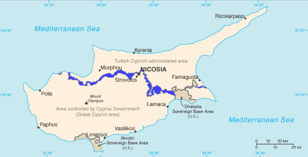
Cyprus_BufferZoneInBlue.png (630 × 321像素,文件大小:21 KB,MIME类型:image/png)
English: Map of Cyprus with the UN Buffer Zone in blue. The map is adapted from the CIA World Factbook map.
|
|
 |
文件历史
点击某个日期/时间查看对应时刻的文件。
| 日期/时间 | 缩略图 | 大小 | 用户 | 备注 | |
|---|---|---|---|---|---|
| 当前 | 2007年2月11日 (日) 11:13 | | 630 × 321(21 KB) | Hoshie | {{english}} Map of Cyprus with the UN Buffer Zone in blue, the traditional color on maps for British possessions. The map is adapted from the [http://www.cia.gov/cia/publications/factbook/maps/cy-map.gif CIA World Factbook] map. |
文件用途
以下4个页面使用本文件:
全域文件用途
以下其他wiki使用此文件:
- ar.wikipedia.org上的用途
- ca.wikipedia.org上的用途
- Resolució 472 del Consell de Seguretat de les Nacions Unides
- Resolució 482 del Consell de Seguretat de les Nacions Unides
- Resolució 486 del Consell de Seguretat de les Nacions Unides
- Resolució 510 del Consell de Seguretat de les Nacions Unides
- Resolució 526 del Consell de Seguretat de les Nacions Unides
- Resolució 544 del Consell de Seguretat de les Nacions Unides
- Resolució 553 del Consell de Seguretat de les Nacions Unides
- Resolució 634 del Consell de Seguretat de les Nacions Unides
- Resolució 680 del Consell de Seguretat de les Nacions Unides
- Resolució 697 del Consell de Seguretat de les Nacions Unides
- Resolució 1000 del Consell de Seguretat de les Nacions Unides
- Resolució 1283 del Consell de Seguretat de les Nacions Unides
- Resolució 1384 del Consell de Seguretat de les Nacions Unides
- Resolució 1687 del Consell de Seguretat de les Nacions Unides
- Resolució 1847 del Consell de Seguretat de les Nacions Unides
- Resolució 1953 del Consell de Seguretat de les Nacions Unides
- Resolució 1986 del Consell de Seguretat de les Nacions Unides
- Zona coixí
- ckb.wikipedia.org上的用途
- بڕیارنامەی ٤٧٢ی ئەنجومەنی ئاسایش
- بڕیارنامەی ٤٨٢ی ئەنجومەنی ئاسایش
- بڕیارنامەی ٤٨٦ی ئەنجومەنی ئاسایش
- بڕیارنامەی ٤٩٥ی ئەنجومەنی ئاسایش
- بڕیارنامەی ٥١٠ی ئەنجومەنی ئاسایش
- بڕیارنامەی ٥٢٦ی ئەنجومەنی ئاسایش
- بڕیارنامەی ٥٤٤ی ئەنجومەنی ئاسایش
- بڕیارنامەی ٥٥٣ی ئەنجومەنی ئاسایش
- بڕیارنامەی ٥٥٩ی ئەنجومەنی ئاسایش
- بڕیارنامەی ٥٦٥ی ئەنجومەنی ئاسایش
- بڕیارنامەی ٥٧٨ی ئەنجومەنی ئاسایش
- بڕیارنامەی ٥٨٥ی ئەنجومەنی ئاسایش
- بڕیارنامەی ٥٩٣ی ئەنجومەنی ئاسایش
- بڕیارنامەی ٥٩٧ی ئەنجومەنی ئاسایش
- بڕیارنامەی ٦٠٤ی ئەنجومەنی ئاسایش
- بڕیارنامەی ٦١٤ی ئەنجومەنی ئاسایش
- بڕیارنامەی ٦٢٥ی ئەنجومەنی ئاسایش
- بڕیارنامەی ٦٣٤ی ئەنجومەنی ئاسایش
- بڕیارنامەی ٦٨٠ی ئەنجومەنی ئاسایش
- بڕیارنامەی ٦٩٧ی ئەنجومەنی ئاسایش
- بڕیارنامەی ٩٢٧ی ئەنجومەنی ئاسایش
- بڕیارنامەی ١٠٠٠ی ئەنجومەنی ئاسایش
- بڕیارنامەی ١٢٨٣ی ئەنجومەنی ئاسایش
- بڕیارنامەی ١٣٨٤ی ئەنجومەنی ئاسایش
- بڕیارنامەی ١٦٨٧ی ئەنجومەنی ئاسایش
- بڕیارنامەی ١٩٥٣ی ئەنجومەنی ئاسایش
- بڕیارنامەی ٢٠٢٦ی ئەنجومەنی ئاسایش
- da.wikipedia.org上的用途
- de.wikipedia.org上的用途
查看本文件的更多全域用途。