File:Detailed map of Benson, Arizona.png
此为最大尺寸。
Detailed_map_of_Benson,_Arizona.png (575 × 425像素,文件大小:24 KB,MIME类型:image/png)

|
此city map图片可使用矢量图形重新创建为SVG文件。这具有很多好处;更多信息请参见共享资源:待清理媒体。如果存在此图片的SVG格式,请将其上传,然后将此模板替换为
{{vector version available|新图片名称}}。
建议您将SVG命名为“Detailed map of Benson, Arizona.svg”,这样在使用Vector version available(或Vva)模板时就不需要填写新图片名称参数。 |
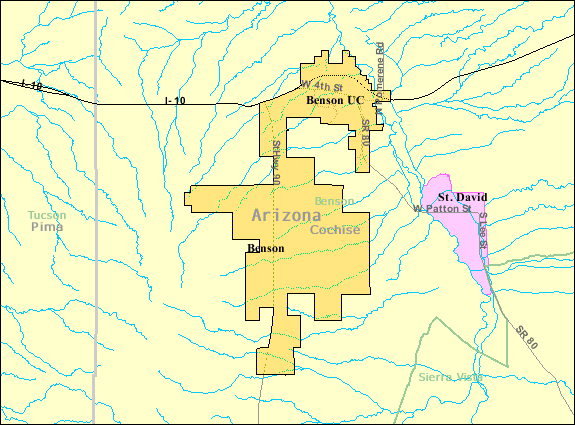
| 描述 | Map of Benson, a city in Cochise County, Arizona, United States, with its boundaries at the time of the 2000 census. | |||
| 日期 | 未知日期; downloaded by me on 13 December 2008 | |||
| 来源 | http://factfinder.census.gov/leg2/46/120825446.gif, from http://factfinder.census.gov | |||
| 作者 | United States Census Bureau | |||
| 授权 (二次使用本文件) |
|

文件历史
点击某个日期/时间查看对应时刻的文件。
| 日期/时间 | 缩略图 | 大小 | 用户 | 备注 | |
|---|---|---|---|---|---|
| 当前 | 2008年12月14日 (日) 01:57 | | 575 × 425(24 KB) | Nyttend | {{Information |Description=Map of {{w|Benson, Arizona|Benson}}, a city in {{w|Cochise County, Arizona|Cochise County}}, {{w|Arizona}}, {{w|United States}}, with its boundaries at the time of the {{w|2000 United States Census|2000 census}}. |Source=http:// |
文件用途
以下页面使用本文件:
全域文件用途
以下其他wiki使用此文件:
- ar.wikipedia.org上的用途
- arz.wikipedia.org上的用途
- azb.wikipedia.org上的用途
- ca.wikipedia.org上的用途
- ceb.wikipedia.org上的用途
- en.wikipedia.org上的用途
- eu.wikipedia.org上的用途
- fa.wikipedia.org上的用途
- fr.wikipedia.org上的用途
- sr.wikipedia.org上的用途
- sv.wikipedia.org上的用途
- tt.wikipedia.org上的用途
- ur.wikipedia.org上的用途
- www.wikidata.org上的用途
- zh-min-nan.wikipedia.org上的用途