File:Essequiborivermap.png

本预览的尺寸:600 × 600像素。 其他分辨率:240 × 240像素 | 480 × 480像素 | 1,000 × 1,000像素。
原始文件 (1,000 × 1,000像素,文件大小:1.41 MB,MIME类型:image/png)
摘要
| 描述 |
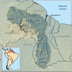
English: This is a map of the Essequibo River drainage basin. |
| 日期 | |
| 来源 | 自己的作品 using Digital Chart of the World and GTOPO data. |
| 作者 | Kmusser |
| 其他版本 | 此文件衍生的作品: Guayana Esequiba (zonas).png |
.png)
许可协议
我,本作品著作权人,特此采用以下许可协议发表本作品:
本文件采用知识共享署名-相同方式共享 3.0 未本地化版本许可协议授权。
- 您可以自由地:
- 共享 – 复制、发行并传播本作品
- 修改 – 改编作品
- 惟须遵守下列条件:
- 署名 – 您必须对作品进行署名,提供授权条款的链接,并说明是否对原始内容进行了更改。您可以用任何合理的方式来署名,但不得以任何方式表明许可人认可您或您的使用。
- 相同方式共享 – 如果您再混合、转换或者基于本作品进行创作,您必须以与原先许可协议相同或相兼容的许可协议分发您贡献的作品。
文件历史
点击某个日期/时间查看对应时刻的文件。
| 日期/时间 | 缩略图 | 大小 | 用户 | 备注 | |
|---|---|---|---|---|---|
| 当前 | 2023年5月30日 (二) 19:43 | | 1,000 × 1,000(1.41 MB) | Usedbook | Reverted to Kmusser (7 April 2010) due to possible vandalism. SurinameCentral erased Guyana's borders in the miniature map of South America. This was clearly not the intention of the original author. |
| 2023年4月1日 (六) 17:40 |  | 1,000 × 1,000(1.4 MB) | SurinameCentral | Borders Changed to Disputed Lines, Border river mouth Corantijn corrected. the entire river is the territory of Suriname. | |
| 2010年4月7日 (三) 17:53 |  | 1,000 × 1,000(1.41 MB) | Kmusser | Added topology (source: SRTM) | |
| 2008年9月11日 (四) 17:15 |  | 1,000 × 1,000(336 KB) | Kmusser | {{Information |Description=This is a map of the Essequibo River drainage basin. |Source=Own work using http://www.maproom.psu.edu/dcw/ Digital Chart of the World and [[http://edc.usgs.gov/products/elevation/gtopo30/gtopo30.html |
文件用途
全域文件用途
以下其他wiki使用此文件:
- af.wikipedia.org上的用途
- az.wikipedia.org上的用途
- be.wikipedia.org上的用途
- bg.wikipedia.org上的用途
- bn.wikipedia.org上的用途
- ca.wikipedia.org上的用途
- ceb.wikipedia.org上的用途
- cs.wikipedia.org上的用途
- da.wikipedia.org上的用途
- de.wikipedia.org上的用途
- en.wikipedia.org上的用途
- Geography of Guyana
- Essequibo River
- Cuyuní River
- Rupununi
- User:Kmusser
- User:Kmusser/Images
- Mazaruni River
- Hogg Island, Guyana
- Guyana–Venezuela territorial dispute
- Talk:Guyana–Venezuela territorial dispute
- Guyana
- List of rivers of Guyana
- Wenamu River
- Rewa River (Guyana)
- Wikipedia:WikiProject Rivers/Maps
- User:Ivan Mangal/sandbox
- User:Alejitao123/sandbox/Copy-edit/Guyana-Venezuela Dispute
- es.wikipedia.org上的用途
查看本文件的更多全域用途。