File:Finland 1996 CIA map.jpg
本预览的尺寸:498 × 599像素。 其他分辨率:199 × 240像素 | 399 × 480像素 | 638 × 768像素 | 851 × 1,024像素 | 1,662 × 2,000像素。
原始文件 (1,662 × 2,000像素,文件大小:2.5 MB,MIME类型:image/jpeg)
| 描述 |
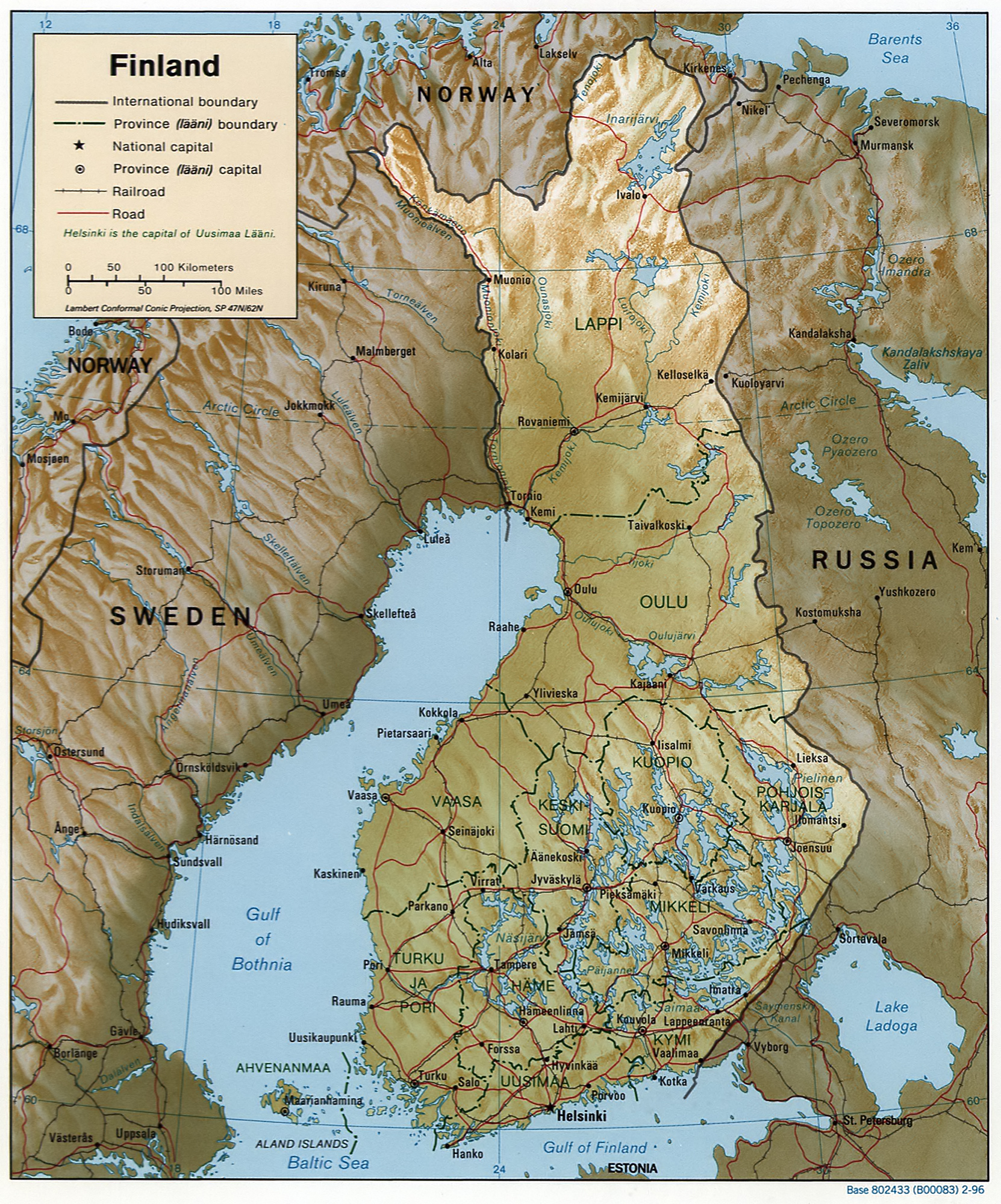
English: Map of Finland, relief shown by shading. Scale [ca. 1:6,250,000]; Lambert conformal conic proj. (E 180--E 340/N 720--N 590); map 20 x 17 cm; "Base 802433 (B00083) 2-96." |
|||
| 日期 | ||||
| 来源 |
REPOSITORY Library of Congress Geography and Map Division Washington, D.C. 20540-4650 USA DIGITAL ID g6960 ct001018 http://hdl.loc.gov/loc.gmd/g6960.ct001018 CALL NUMBER G6960 1996 .U6 |
|||
| 作者 | Central Intelligence Agency, Washington, D.C., United States. | |||
| 授权 (二次使用本文件) |
|

文件历史
点击某个日期/时间查看对应时刻的文件。
| 日期/时间 | 缩略图 | 大小 | 用户 | 备注 | |
|---|---|---|---|---|---|
| 当前 | 2007年2月19日 (一) 12:48 | | 1,662 × 2,000(2.5 MB) | Zarex | reduced the noise |
| 2005年10月27日 (四) 08:26 |  | 1,662 × 2,000(1.5 MB) | Brian0918 | Finland. United States. Central Intelligence Agency. CREATED/PUBLISHED [Washington, D.C. : Central Intelligence Agency, 1996] NOTES Relief shown by shading. "Base 802433 (B00083) 2-96." Also issued without shaded relief. Scale [ca. 1:6,250,000] ; La |
文件用途
没有页面链接到本图像。
全域文件用途
以下其他wiki使用此文件:
- as.wikipedia.org上的用途
- az.wiktionary.org上的用途
- be.wikipedia.org上的用途
- bg.wikipedia.org上的用途
- bjn.wikipedia.org上的用途
- bug.wikipedia.org上的用途
- ch.wikipedia.org上的用途
- da.wikipedia.org上的用途
- de.wikipedia.org上的用途
- en.wikipedia.org上的用途
- en.wiktionary.org上的用途
- es.wikipedia.org上的用途
- fa.wikipedia.org上的用途
- fi.wikinews.org上的用途
- fj.wikipedia.org上的用途
- fr.wikipedia.org上的用途
- gl.wikipedia.org上的用途
- hu.wikipedia.org上的用途
- id.wikipedia.org上的用途
- ig.wikipedia.org上的用途
- io.wikipedia.org上的用途
- it.wikipedia.org上的用途
- kn.wikipedia.org上的用途
- ks.wikipedia.org上的用途
- lbe.wikipedia.org上的用途
- map-bms.wikipedia.org上的用途
- mdf.wikipedia.org上的用途
- min.wikipedia.org上的用途
- nn.wikipedia.org上的用途
- no.wikipedia.org上的用途
- nso.wikipedia.org上的用途
- pfl.wikipedia.org上的用途
- pl.wikipedia.org上的用途
- pt.wikipedia.org上的用途
- rn.wikipedia.org上的用途
- ro.wikipedia.org上的用途
- ru.wikipedia.org上的用途
- sd.wikipedia.org上的用途
- sg.wikipedia.org上的用途
查看此文件的更多全域用途。