File:Keurusselka-WorldWind.jpg
本预览的尺寸:413 × 599像素。 其他分辨率:165 × 240像素 | 563 × 816像素。
原始文件 (563 × 816像素,文件大小:183 KB,MIME类型:image/jpeg)
摘要
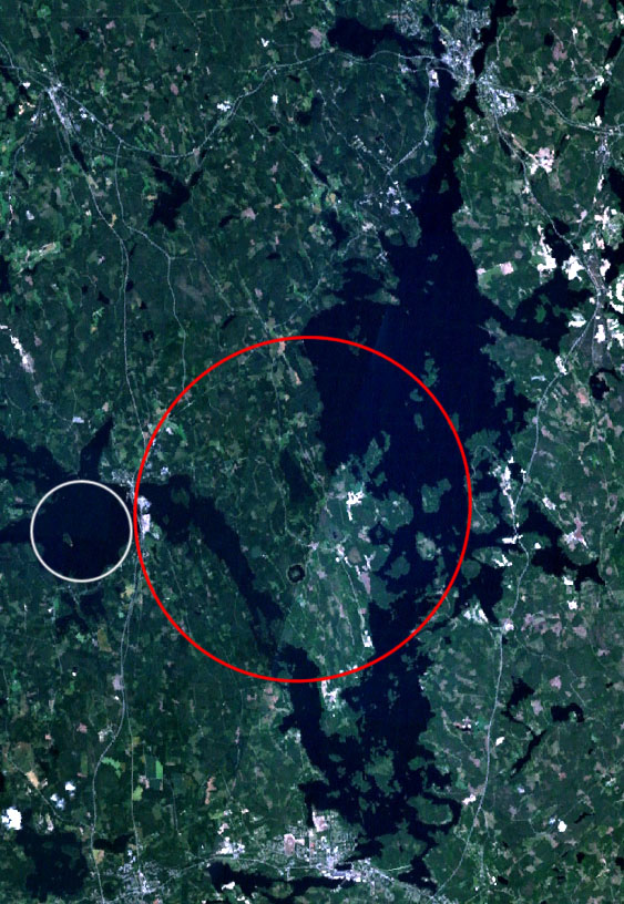
| 描述 | Landsat 7 satellite image of the Keurusselkä lake region. Keurusselkä impact structure is marked with a red ellipse, suggested impact structure of Ukonselkä is marked with a white circle |
| 日期 | 2006年5月6日, 20:36:52 (根据EXIF的数据) |
| 来源 | NASA WorldWind; data based on J. Moilanen's map [1] and the SEIS database [2] |
| 作者 | NASA |
| 授权 (二次使用本文件) |
NASA PD |
许可协议
| 本圖像屬於公有領域,因其為NASA的World Wind衛星地圖瀏覽器的一張截圖,且使用了公有領域圖層,如Blue Marble、MODIS、Landsat、SRTM、USGS、GLOBE等。
|
 |
文件历史
点击某个日期/时间查看对应时刻的文件。
| 日期/时间 | 缩略图 | 大小 | 用户 | 备注 | |
|---|---|---|---|---|---|
| 当前 | 2006年5月6日 (六) 17:45 | | 563 × 816(183 KB) | Jyril | {{Information| |Description=Landsat 7 satellite image of the Keurusselkä lake region. Keurusselkä impact structure has been marked with red circle, suggested impact structure of Ukonselkä is marked with white circle |Source=NASA WorldWind; data based o |
文件用途
以下页面使用本文件:
全域文件用途
以下其他wiki使用此文件:
- arz.wikipedia.org上的用途
- ceb.wikipedia.org上的用途
- de.wikipedia.org上的用途
- en.wikipedia.org上的用途
- eo.wikipedia.org上的用途
- es.wikipedia.org上的用途
- fi.wikipedia.org上的用途
- fr.wikipedia.org上的用途
- nn.wikipedia.org上的用途
- no.wikipedia.org上的用途
- pl.wikipedia.org上的用途
- ru.wikipedia.org上的用途
- sv.wikipedia.org上的用途
- uk.wikipedia.org上的用途
- www.wikidata.org上的用途