File:Mediterranean chart fourteenth century2.jpg

原始文件 (5,486 × 4,009像素,文件大小:17.24 MB,MIME类型:image/jpeg)
|
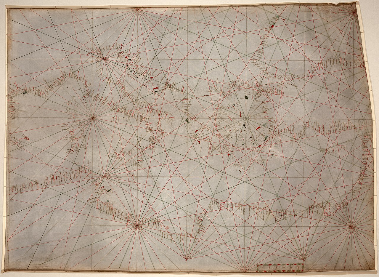
| 这是一张修改过的图片,这意味着它已在原版本的基础上通过软件进行了编辑,改动内容:stains, dirt, and creases removed, some lines reconstructed, selective brightness changes, histogram adjusted, and colors balanced。其原始版本为:Mediterranean chart fourteenth century.jpg。修改者: Durova。
|
摘要
| 描述 |
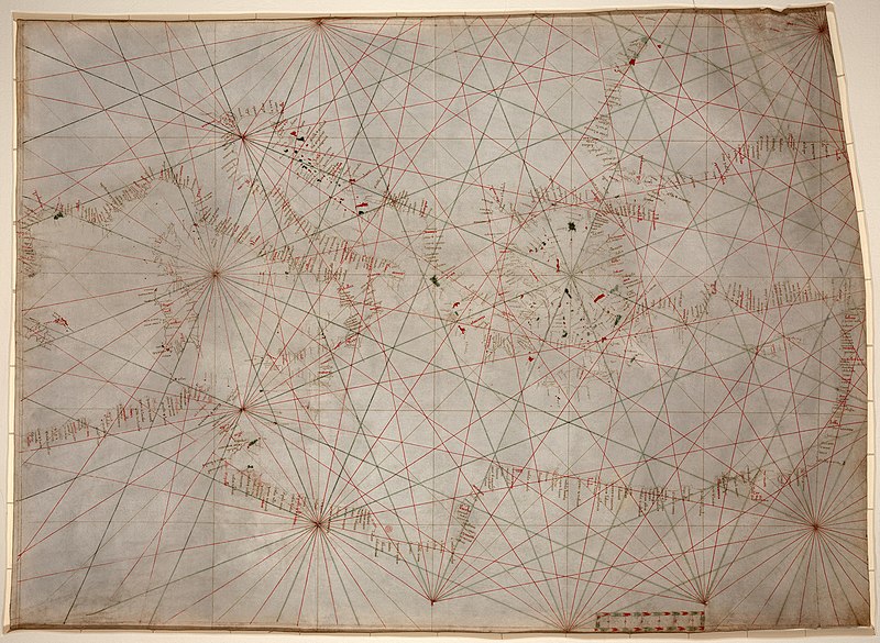
Anonymous nautical chart in portolan style probably drawn in Genoa. Covers Mediterranean Sea from the Balearic Islands to the Levantine coast; also covers western part of Black Sea. Oldest original cartographic artifact in the Library of Congress. Title from printed label on box in which the map is housed. Pen-and-ink (red/green/brown). Matted and mounted between sheets of transparent lucite. Sheet cut into the shape of an irregular rectangle. Imperfect: Vertically fold-lined at center, cracked, annotated in pencil on verso. Includes bar scale with unidentified divisions. The green rhumb lines on the recto are also visible on the verso. Scale [ca. 1:5,500,000]. |
||||
| 日期 | 约1320年~1350年间 | ||||
| 来源 | Library of Congress[1] | ||||
| 作者 | anonymous, probably Genoan | ||||
| 授权 (二次使用本文件) |
|
||||
| 其他版本 |
此文件衍生的作品: |
||||
.jpg)
.jpg)
文件历史
点击某个日期/时间查看对应时刻的文件。
| 日期/时间 | 缩略图 | 大小 | 用户 | 备注 | |
|---|---|---|---|---|---|
| 当前 | 2009年1月18日 (日) 02:53 | | 5,486 × 4,009(17.24 MB) | Durova | {{Information |Description=Anonymous nautical chart in portolan style probably drawn in Genoa. Covers Mediterranean Sea from the Balearic Islands to the Levantine coast; also covers western part of Black Sea. Oldest original cartographic artifact in t |
文件用途
以下页面使用本文件:
全域文件用途
以下其他wiki使用此文件:
- ar.wikipedia.org上的用途
- ca.wikipedia.org上的用途
- en.wikipedia.org上的用途
- Portolan chart
- Wikipedia:Featured pictures/Diagrams, drawings, and maps/Maps
- Wikipedia:Featured pictures thumbs/15
- Wikipedia:Featured picture candidates/January-2009
- Wikipedia:Featured picture candidates/Portolan chart of the Mediterranean
- Wikipedia:Wikipedia Signpost/2009-01-31/Features and admins
- User talk:Durova/Archive 65
- Wikipedia:Picture of the day/October 2009
- User:Durova/Featured credits at the Turkish language Wikipedia
- Template:POTD/2009-10-22
- User talk:Durova/Archive 73
- User:Durova/Featured picture gallery/2009
- User:Walrasiad/Maps
- Rule of marteloio
- Wikipedia:Wikipedia Signpost/2009-01-31/SPV
- Wikipedia:Wikipedia Signpost/Single/2009-01-31
- es.wikipedia.org上的用途
- et.wikipedia.org上的用途
- eu.wikipedia.org上的用途
- gl.wikipedia.org上的用途
- he.wikipedia.org上的用途
- hr.wikipedia.org上的用途
- incubator.wikimedia.org上的用途
- it.wikipedia.org上的用途
- ja.wikipedia.org上的用途
- ko.wikipedia.org上的用途
- mn.wikipedia.org上的用途
- ms.wikipedia.org上的用途
- pl.wikipedia.org上的用途
- ps.wikipedia.org上的用途
- pt.wikipedia.org上的用途
- sh.wikipedia.org上的用途
- si.wikipedia.org上的用途
- sl.wikipedia.org上的用途
- sr.wikipedia.org上的用途
- ta.wikipedia.org上的用途
- th.wikipedia.org上的用途
- tr.wikipedia.org上的用途
查看本文件的更多全域用途。