File:Mexican Cession in Mexican View.PNG

本预览的尺寸:680 × 599像素。 其他分辨率:272 × 240像素 | 545 × 480像素 | 872 × 768像素 | 1,068 × 941像素。
原始文件 (1,068 × 941像素,文件大小:135 KB,MIME类型:image/png)

|
此map图片可使用矢量图形重新创建为SVG文件。这具有很多好处;更多信息请参见共享资源:待清理媒体。如果存在此图片的SVG格式,请将其上传,然后将此模板替换为
{{vector version available|新图片名称}}。
建议您将SVG命名为“Mexican Cession in Mexican View.svg”,这样在使用Vector version available(或Vva)模板时就不需要填写新图片名称参数。 |
摘要
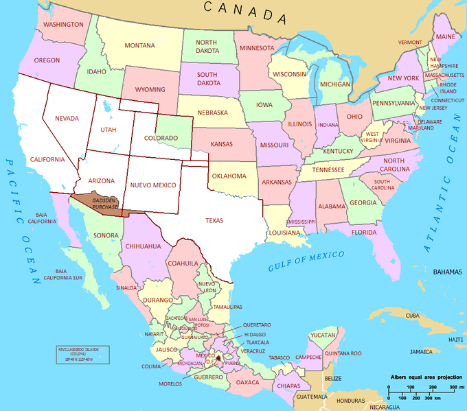
| 描述 | Mexican Cession in Mexican View |
| 日期 | 01/07/2009 |
| 来源 | U.S._Territorial_Acquisitions.png |
| 作者 | United States federal government (en:User:Black and White converted it from JPEG to PNG and retouched it) |
| 授权 (二次使用本文件) |
This map was obtained from an edition of the National Atlas of the United States. Like almost all works of the U.S. federal government, works from the National Atlas are in the public domain. |
许可协议
| 我,本作品著作权人,释出本作品至公有领域。这适用于全世界。 在一些国家这可能不合法;如果是这样的话,那么: 我无条件地授予任何人以任何目的使用本作品的权利,除非这些条件是法律规定所必需的。 |
文件历史
点击某个日期/时间查看对应时刻的文件。
| 日期/时间 | 缩略图 | 大小 | 用户 | 备注 | |
|---|---|---|---|---|---|
| 当前 | 2011年9月22日 (四) 21:02 | | 1,068 × 941(135 KB) | Hpav7 | ajustes |
| 2010年1月18日 (一) 04:39 |  | 1,068 × 941(135 KB) | Jaimiko | Se agrego la totalidad del territorio Mexicano y la division de los estados de Mexico. Was added the entire Mexican territory and the division of states of Mexico. | |
| 2009年7月1日 (三) 21:59 |  | 1,066 × 721(107 KB) | Jaimiko | {{Information |Description= Mexican Cession in Mexican View |Source= U.S._Territorial_Acquisitions.png |Date= 01/07/2009 |Author=United States federal government (en:User:Black and White converted it from JPEG to PNG and retouched it) |Permission=This map |
文件用途
全域文件用途
以下其他wiki使用此文件:
- af.wikipedia.org上的用途
- ca.wikipedia.org上的用途
- cs.wikipedia.org上的用途
- de.wikipedia.org上的用途
- en.wikipedia.org上的用途
- es.wikipedia.org上的用途
- fa.wikipedia.org上的用途
- fi.wikipedia.org上的用途
- fr.wikipedia.org上的用途
- hr.wikipedia.org上的用途
- hu.wikipedia.org上的用途
- it.wikipedia.org上的用途
- ja.wikipedia.org上的用途
- ms.wikipedia.org上的用途
- sh.wikipedia.org上的用途
- ta.wikipedia.org上的用途
- th.wikipedia.org上的用途
- zh-min-nan.wikipedia.org上的用途