File:Ojai, California (20960249094) (cropped).jpg

原始文件 (3,523 × 1,870像素,文件大小:2.15 MB,MIME类型:image/jpeg)
摘要
| 描述 |
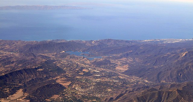
Ojai is a city in Ventura County, California, USA. It is situated in the Ojai Valley, approximately 10 miles long by 3 miles (4.8 km) wide or 16 kilometers by 5 kilometers, surrounded by hills and mountains. In 2003, the estimated population was 8,006, making it one of the smaller towns in the county. Chumash Indians were the early inhabitants of the valley. They called it Ojai, which means "Valley of the Moon." The area eventually became one of many Spanish/Mexican land grants along the California coast. In 1837, it was granted to Fernando Tico and he established a cattle rancho. Tico sold it in 1853 to prospectors searching for oil, without much success. By 1864, the area was settled. After fire destroyed much of the original western-style Nordhoff/Ojai in 1917, Libbey helped design, finance and build a new downtown more in line with the contemporary taste for Colonial-Revival architecture, including a Spanish-style arcade, a bell-tower reminiscent of the famous campanile in Havana, and a pergola opposite the arcade. These buildings still stand, and have come to serve as symbols of the city and the surrounding valley. Ojai is situated in a small east-west valley, north of Ventura and east of Santa Barbara. It is approximately 15 miles (24 km) inland from the Pacific coast. Since Ojai is lined up with an east-west mountain range, it is one of few towns in the world to have the Pink Moment occur as the sun is setting. The fading sunlight creates a brilliant shade of pink on the Topatopa Bluffs that stand at the east end of the Ojai Valley, reaching over 6,000 feet (1,800 m) above sea level. Nordhoff Ridge, the western extension of the Topatopa Mountains, towers over the north side of the town and valley at more than 5,000 feet (1,500 m). Sulphur Mountain creates the southern ranges bounding the Ojai Valley, a little under 3,000 feet (910 m) in elevation. The Ventura River flows through the Ventura River Valley, draining the mountains surrounding Ojai to the north and east and emptying into the Pacific Ocean at the city of Ventura. The climate of Ojai is Mediterranean, characterized by hot, dry summers (sometimes exceeding 100°F) and mild winters, with lows at night sometimes below freezing. As is typical for much of coastal southern California, most precipitation falls in the form of rain between the months of October and April, with intervening dry summers. The town of Ojai and its surrounding area is home to many unique recreational activities. Los Padres National Forest borders the town on the north, and many backcountry areas within the forest are accessible from Highway 33, which is the major highway through town south to north. en.wikipedia.org/wiki/Ojai,_California en.wikipedia.org/wiki/Wikipedia:Text_of_Creative_Commons_... |
| 日期 | |
| 来源 | Ojai, California |
| 作者 | Ken Lund from Reno, Nevada, USA |
| 其他版本 |
.jpg)
_(cropped).jpg?uselang=zh)
_(cropped).jpg?uselang=zh)
_(cropped).jpg?action=history&uselang=zh)
_(cropped).jpg)
| 相机位置 | | 在以下服务上查看本图像和附近其他图像: OpenStreetMap |
|---|
_(cropped).jpg¶ms=034.559144_N_-119.050317_E_globe:Earth_type:camera_source:Flickr_&language=zh)
许可协议
- 您可以自由地:
- 共享 – 复制、发行并传播本作品
- 修改 – 改编作品
- 惟须遵守下列条件:
- 署名 – 您必须对作品进行署名,提供授权条款的链接,并说明是否对原始内容进行了更改。您可以用任何合理的方式来署名,但不得以任何方式表明许可人认可您或您的使用。
- 相同方式共享 – 如果您再混合、转换或者基于本作品进行创作,您必须以与原先许可协议相同或相兼容的许可协议分发您贡献的作品。
文件历史
点击某个日期/时间查看对应时刻的文件。
| 日期/时间 | 缩略图 | 大小 | 用户 | 备注 | |
|---|---|---|---|---|---|
| 当前 | 2018年11月26日 (一) 21:52 | | 3,523 × 1,870(2.15 MB) | Cristiano Tomás | Cropped 16 % vertically using CropTool with precise mode. |
| 2018年11月26日 (一) 21:49 |  | 3,523 × 2,230(2.71 MB) | Cristiano Tomás | File:Ojai, California (20960249094).jpg cropped 12 % horizontally, 26 % vertically using CropTool with precise mode. |
.jpg)
文件用途
以下页面使用本文件:
全域文件用途
以下其他wiki使用此文件:
- azb.wikipedia.org上的用途
- en.wikipedia.org上的用途
- mn.wikipedia.org上的用途
- nv.wikipedia.org上的用途
- pl.wikipedia.org上的用途
- simple.wikipedia.org上的用途
- sw.wikipedia.org上的用途
- uk.wikipedia.org上的用途
- ur.wikipedia.org上的用途
_(cropped).jpg)