File:Southern British Isles 9th century.svg

此SVG文件的PNG预览的大小:629 × 435像素。 其他分辨率:320 × 221像素 | 640 × 443像素 | 1,024 × 708像素 | 1,280 × 885像素 | 2,560 × 1,770像素。
原始文件 (SVG文件,尺寸为629 × 435像素,文件大小:1.95 MB)
| 描述 |
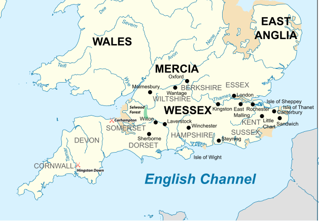
English: Map of the Southern British Isles during the 9th century |
| 日期 | |
| 来源 | 自己的作品 Incorporates elements of this map. Locations are based on the Ordinance Survey Atlas of Great Britain, apart from Selwood Forest, which is taken from Barbara Yorke, Wessex in the Early Middle Ages, 1995, p. 23, ISBN 0 7185 1856 X |
| 作者 | Philg88; Attribution: Wikimedia Foundation (www.wikimedia.org) |
| 授权 (二次使用本文件) |
W3C-validity not checked. 本W3C状态不明的矢量图使用Adobe Illustrator创作. |
文件历史
点击某个日期/时间查看对应时刻的文件。
| 日期/时间 | 缩略图 | 大小 | 用户 | 备注 | |
|---|---|---|---|---|---|
| 当前 | 2015年7月19日 (日) 17:30 | | 629 × 435(1.95 MB) | Philg88 | User requested modifications |
| 2015年7月19日 (日) 16:00 |  | 629 × 435(1.65 MB) | Philg88 | {{Information |Description ={{en|1=Map of the Southern British Isles during the 9th century}} |Source ={{own}} Incorporates elements of [https://commons.wikimedia.org/wiki/File:British_Isles_10th_century.svg this map] |Author =[[User... |
文件用途
以下页面使用本文件:
全域文件用途
以下其他wiki使用此文件:
- bn.wikipedia.org上的用途
- br.wikipedia.org上的用途
- cs.wikipedia.org上的用途
- el.wikipedia.org上的用途
- en.wikipedia.org上的用途
- es.wikipedia.org上的用途
- fa.wikipedia.org上的用途
- he.wikipedia.org上的用途
- ja.wikipedia.org上的用途
- ko.wikipedia.org上的用途
- ms.wikipedia.org上的用途
- sk.wikipedia.org上的用途
- th.wikipedia.org上的用途
- tr.wikipedia.org上的用途