HiWish计划
HiWish是美国航空航天局创立的一项计划,其宗旨是动员所有人为火星勘测轨道飞行器上的高分辨率成像科学设备相机推荐一处拍摄地点[1][2][3]。该计划于2010年1月启动。在启动后的头几个月内,曾有3000人注册使用高分辨率成像科学设备[4][5],首批图像于2010年4月发布[6]。公众先后提出过12000多条建议,对火星上30个分区都提出了各自的目标。在第16届国际火星协会年会上,这些推荐拍摄的图像被用于三次演讲。以下是截至2016年3月HiWish计划发布的4224张图片中的一部分[7]。
冰川特征 编辑
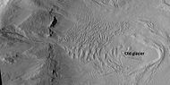
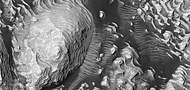
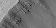
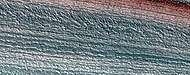
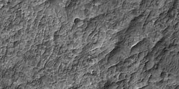
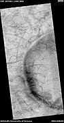
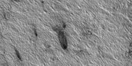
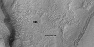
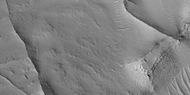
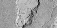
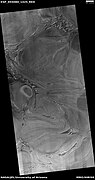
有些景观看上去类似地球上冰川流过的谷道,就像所有积冰消融后,谷底只剩下划痕和冰碛—冰川携带的泥土和碎屑的空谷[8]。这些所谓的高山冰川被称作类冰川形态(GLF)或类冰川流(GLF)[9]。类冰川形态是一条更晚的术语,可能更准确,因为无法确定这类结构当前是否还在移动[10]。
,

-
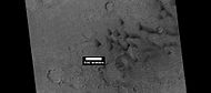
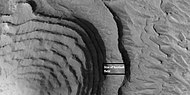
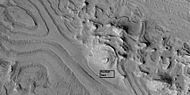
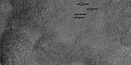
 可能是冰川沿着山谷流下并在平原上摊开,矩形显示了下一幅图像中放大的部分。
 -
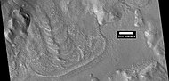
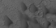
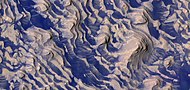
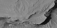
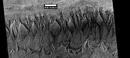
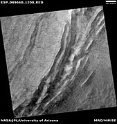
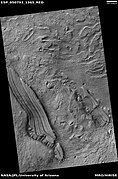
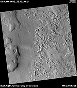
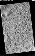
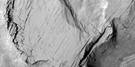
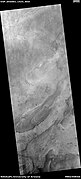
 上一幅图像中矩形区域的放大,该区域在地球上被称为高山冰川中的冰碛。
 -
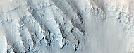
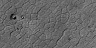
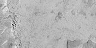
 发育良好的同心坑沉积凹陷。
 -
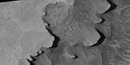
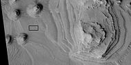
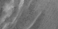
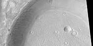
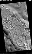
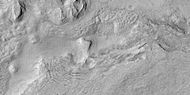
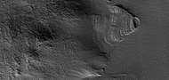
 陨石坑底表上的冰川,冰川中的裂纹可能是一些深裂缝,陨坑壁上还分布有冲沟系统。
 -


-
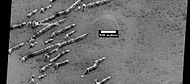
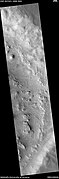
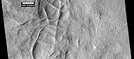
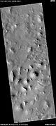
 舌状流的全景图
 -
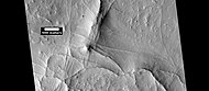
 近距离观察到的舌状流


可能的冰核丘 编辑
当作用力穿透脆性层时,通常可看到放射和同心状裂纹,比如被石头砸破的玻璃窗,这些特殊的裂缝可能是火星脆性表面下出现的某些东西所造成。水冰可能呈镜面状积聚在地表下,冰的密度比岩石小,当被推升到到表面后,就会呈现蜘蛛网般的图纹,从而也就形成了这些有裂缝的土墩,这一过程与地球北极苔原上相似大小土墩的形成过程类似。这些特征被称为“冰核丘”(平戈斯),因纽特人词汇[11]。冰核丘含有纯水冰,因此,它们可能成为未来火星定居者的水源,许多看起来像地球上冰核丘的特征都可在乌托邦平原(北纬35-50°、东经80-115°)[12]找到。
-
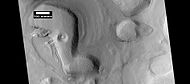
 可能的冰核丘,照片带比例尺。
 -
 可能冰核丘的近距观察。


古老河流和溪流 编辑
有大量证据表明水曾经在火星的河谷中流动过,来自轨道飞行器的图片显示了蜿蜒的河谷、叉谷,甚至还有逶迤弯曲的牛轭湖[13],下面的图片显示了其中的一些。


流线体 编辑
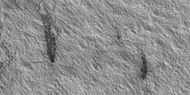
流线型形状代表了火星上以前水流的更多证据,水流将地貌塑造成了流线体。


新撞击坑 编辑
-
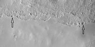
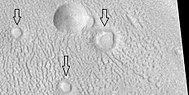
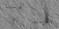
 高分辨率成像科学设备图像显示了新发现的撞击坑,白色箭头所示的新陨石坑直径约10码,可能是一颗大西瓜般的物体碰撞造成,在早期拍摄的该地区照片中并未显示有这一陨坑。

沙丘 编辑
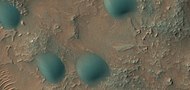
火星上许多地方都有沙丘,沙丘被季节性二氧化碳霜冻覆盖,这种霜冻于初秋形成,一直持续到晚春。很多火星沙丘与陆地沙丘非常相似,但火星勘测轨道器高分辨率成像科学设备获得的图像表明,火星北极地区的沙丘会受到季节性二氧化碳升华引发的颗粒流的改变,这是地球上从未见过的过程。许多沙丘呈黑色,因为它们来源于黑色火山岩玄武岩。地外沙海,例如在火星上发现的沙海,被称为“undae”-来自拉丁语“波浪”。
-
 高分辨率成像科学设备在二座撞击坑中发现的沙丘。
 -
 撞击坑之间的沙丘,其中一些呈新月形。
 -
 艾利达尼亚区一座撞击坑底部的沙丘,其中大部分为新月形沙丘,方框显示了下一幅图像的位置。
 -
 撞击坑底部的沙丘,其中大部分是新月形沙丘。注意:这是放大的前一幅图像中心区。
 -
 艾利达尼亚区的沙丘。
 -
 除霜沙丘和多边形凹槽中的冰
 -
 除霜沙丘和多边形凹槽中冰的彩照
 -
 解冻的表面,沙丘上的霜冻正在一片片地消失,但环多边形地表的凹槽边界仍然含有霜,因此它们是白色的。注意:沙丘北侧边沿尚未解冻,因为太阳光来自另一侧。
 -
 莫罗撞击坑内沙丘全景图
 -
 第勒尼安海区的沙丘
 -
 第勒尼安海区沙丘近景图
 -
 第勒尼安海区沙丘彩色近景图,在沙丘表面可看到波纹。
 -
 圆顶沙丘的彩色近景图


着陆点 编辑
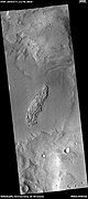
一些建议的目标成为2020年火星车任务的可能地点,目标地位于菲尔索夫和霍顿撞击坑,这些地点是26处列选地点中的其中两处,用以寻找生命迹象并收集样本,并在以后带回地球[14][15][16]。
-
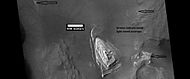
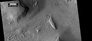
 菲尔索夫陨击坑中的岩层,注:图像中区域可在先前菲尔索夫撞击坑岩层的图像中找到,火星侦察轨道器背景相机拍摄。
 -
 菲索夫陨击坑内各岩层特写,这是前一幅图像的放大版。
 -
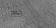
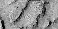
 带有显示足球场大小方框的菲索夫陨击陨击坑岩层照片。
 -
 菲尔索夫陨击坑内的岩层和断层,箭头显示了一处大断层,但图中还有其他较小的断层。
 -
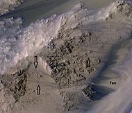
![霍顿撞击坑中的部分三角洲,霍尔顿撞击坑是计划于 2020 年发射的火星探测车可能着陆点[17]。](//upload.wikimedia.org/wikipedia/commons/thumb/e/e9/ESP_026126_1530delta.jpg/80px-ESP_026126_1530delta.jpg)
-
 上一幅显示岩层照片的近景图。


![霍顿撞击坑中的部分三角洲,霍尔顿撞击坑是计划于 2020 年发射的火星探测车可能着陆点[17]。](/wiki/File:ESP_026126_1530delta.jpg)

景观特征 编辑


暗坡条纹 编辑


重现性坡线 编辑
重现性坡线是温暖季节延伸在斜坡上一些细小的暗色条纹,它们可能是液态水的证据[18][19][20]。然而,有关是否是水或需要多少水仍存有争议[21] [22] [23]。
-
 水手谷部分地区广角视图,方框显示的重现性坡线位置将在下一幅图像中被放大。
 -
 重现性坡线彩色近景图,箭头指示了一些重现性坡线。


岩层 编辑
火星上的许多地方都有重叠的岩层,岩石可以以多种方式形成岩层,火山、风或水可以形成地层[24],地下水的作用可以使地层变硬。
,


-
 丹尼尔森陨击坑底部的层状墩。
 -
 丹尼尔森陨击坑地面上岩层和黑色尘埃彩色近景图。
 -
 丹尼尔森陨击坑地面上的岩层和黑色尘埃彩色近景图,可在图像中看到巨岩。
 -
 尼尔森陨击坑地面上的岩层和黑色尘埃彩色近景图,箭头指示了断层处。
 -
 丹尼尔森陨击坑地面岩层近景图,在图像中可看到一些断层。


-
-
 放大的白色岩丘,方框显示了足球场大小的区域。
 -
 朝向白色岩丘顶部的近景图,方框显示了足球场大小的区域。
 -
 白色岩丘的顶部,方框显示了足球场大小的区域。


-
 埃俄利斯区中的层状地形。
 -

-
 层状丘近景景,注意:这是上一幅图像的放大版。
 -
 层状丘近景景,注意:这是先前图像的放大版
 -
 阿拉伯区里的层状地形,
 -
 丹尼尔森撞击坑部分区域的广角视图。
 -
 前一幅丹尼尔森撞击坑图像的放大版,方框显示足球场大小的区域。
 -
 丹尼尔森撞击坑地层特写-可以看到巨石和黑色沙粒。
 -
 伊乌斯峡谷南部槽沟中的地层特写图。
 -
 洛托陨击坑(Lotto)中的岩层特写
 -
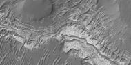
 滕比高地区的地层
 -
 滕比高地区的地层,注:这是前一幅图像的放大版。


-
 各地层近景图,至少有一层为可能代表水合矿物的浅色层。
 -
 各地层近景图


这组岩层都来自阿拉伯区的一座撞击坑中。
-
 撞击坑各地层的广角视图,该图像的部分区域将在后面的其他图像中放大。
 -
 地层近景图,方框显示了足球场大小的区域。
 -
 地层近景图,方框显示了足球场大小的区域。
 -
 地层近景图,方框显示了足球场大小的区域。
 -
 地层近景图
地层近景图 -
 地层近景图
地层近景图 -
 地层近景图
地层近景图 -
 地层近景图
地层近景图 -
 地层近景图
地层近景图


-
 卢罗斯谷中的地层近景图
 -
 卢罗斯谷中的地层近景图,注:这是前一幅图像的放大版。
 -
 卢罗斯谷中的地层近景图,注:这是前一幅图像的放大版。
 -
 卢罗斯谷中的地层近景图,注:这是前一幅图像的放大版。
 -
 卢罗斯谷中的地层近景图,注:这是前一幅图像的放大版。


冰盖中的层状结构 编辑
-
 北部冰盖中角度不一致的地层。
 -
 北部冰盖地层近景图,箭头指示了不一致的角度。
 -
 北部冰盖地层彩色近景图
 -
 北部冰盖中暴露的地层
 -
 北部冰盖中暴露的地层


冲沟 编辑
火星冲沟是在火星上发现的一系列狭窄冲刷沟壑以及相关的下坡沉积物,因与地球上的冲沟相似而得名,最早是在火星全球探勘者号拍摄的图像中所发现,它们常出现在陡坡上,特别是陨石坑的坑壁上。通常,每条冲沟沟头都有一处水系蓄水洼地,坡下则形成一片冲积扇,还有连接两条冲沟的细叉沟,使整个冲沟呈沙漏状[25]。人们认为这些冲沟相对年轻,因为上面几乎没有覆盖陨石坑。
根据它们的类型、外观、位置和地点以及与被认为是富含水冰地貌的明显相互作用,许多研究人员认为,凿刻冲沟的过程涉及液态水。然而,这仍然是一个有待进一步研究的课题。
,

-
 冲积扇特写,显示上面没有陨石坑;因此很年轻。位置为法厄同区。
 -
 阿西达里亚海区一座撞击坑内侧坡壁上的冲沟。
 -
 冲沟渠壑特写。该图像显示了众多流线型特征和一些沿沟渠延伸的阶坎,表明它们是由水流形成的。当水位少量下降并保持一段时间后,通常会形成阶坎。图像拍摄位置为阿西达里亚海区,注意:这是前一幅图像的放大版。
 -
 法厄同区撞击坑内的冲沟。
 -

-
 冲积扇近景图,注:此为前一幅图像的放大。
 -
 沟头洼地近景图,注:此为前一幅图像的放大。


-
 陨石坑中的冲沟
 -
 上一幅图像中的冲沟近景图。冲沟非常弯曲,由于沟渠常形成弯曲状,被认为它们形成于水流。如今,人们认为它们可能是由干冰造成的。


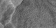
纬度相关覆盖层 编辑
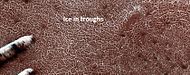
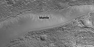
火星大部分表面都有一层富含水冰的厚厚覆盖层,它们是由过去多次从天空飘落的冰芯尘埃所构成[26][27][28],在覆盖层中的部分区域可看到一系列的分层结构[29]。
-

-
 艾利达尼亚区的覆盖层。
 -
 覆盖层近景图,覆盖层可能由过去气候条件下从天空飘落的冰和尘埃组成,位置为刻布壬尼亚区。
 -
 伊斯墨诺斯湖区覆盖层近景图,沿陨坑边沿显示的箭头,突出指示了覆盖层的厚度。
 -
 显示伊斯墨诺斯湖区覆盖层厚度的近景图。


-
 阿耳卡狄亚区表面有斑点的覆盖层广角视图.
 -
 覆盖层近景图
 -
 覆盖层近景图


当雪和尘埃包裹的冰降落后,有充分的证据表明该覆盖层富含水冰。在许多表面常见的多边形表明土壤富含水冰;2001火星奥德赛号发现了高水平的氢(可能来自水)[30][31][32][33][34];轨道上测得的热量表明是冰[35][36];凤凰号(航天器)降落在一处多边形区,发现了水冰并进行了直接观测[37][38],事实上,它的着陆火箭曾暴露出了纯冰。理论预测在几厘米厚的土壤下就会发现水冰,该覆盖层被称为“纬度相关覆盖层”,因为它的存在与所处纬度有关。正是这层覆盖层的破裂,后来才形成了多边形地面,这种富冰地面的开裂是根据物理过程所预测的[39][40]
[41][42][43][44][45]。
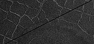
多边形图案地面 编辑
多边形、有图案的地面,在火星一些地区非常常见[46][47][48][49][44][50][51],并被普遍认为这是由地面上冰的升华所导致。升华是固体冰直接变成气体,与地球上干冰的情况类似。火星上呈现多边形地面的地方可能表明未来定居者可在那里找到水冰。图案地面覆盖层是由在气候不同时从天空落下的冰核尘埃所构成,它们又被称为“纬度相关覆盖层” [26][27][52][53]。
,
-
 带霜冻的陨石坑多边形地面广角图。
 -
 较低处带霜冻的多边形地面近景图。
 -
 更接近的多边形地面图
 -
 较低处带霜冻的多边形地面近景图,也可看到圆形的图案


-
 箭头显示中央凸起多边形地面,位于卡西乌斯区,高分辨率成像科学设备放大的图像。
 -
 标注有中央凸起多边形及中央凹陷多边形地面的贴心形地貌,位于卡西乌斯区,高分辨率成像科学设备放大的图像。
 -
 卡西乌斯区中央凸起和凹陷多边形地面,高分辨率成像科学设备放大的图像。
 -
 中央凸起多边形地面特写,多边形之间的凹槽清晰可见。位置为伊斯墨诺斯湖区。
 -
 卡西乌斯区中央凹陷多边形地面,高分辨率成像科学设备放大的图像。
 -
 冰川口近景图,可看到中央凸起多边形,方框显示了足球场大小的区域。
 -
 冰川附近的中央凸起多边形地面近景图,方框显示了足球场大小的区域。
 -
 冰川附近的中央凸起多边形地面近景图。


-
 一组通道广角图,放大后表面某些部分显出图案地面。
 -
 图案地面,前一幅图像的特写。
 -
 山脊,前一幅图像的特写。
 -
 前一幅图像的彩色视图。
 -
 图案在面彩色视图,前一幅的放大版。


复杂多边形图案地面 编辑
-
 挪亚区多边形地面广角图,该图像的部分区域将在后面的图中放大。
 -
 多边形地面
多边形地面 -
 多边形地面近景图,箭头指示了小陨坑内的巨石。
 -
 多边形地面近景图
 -
 多边形地面近景图


裸露的冰盖 编辑
HiWish计划下高分辨率成像科学设备在拍摄的米兰科维奇撞击坑照片中发现了许多三角洼地,研究人员发现,在这些地方仅1-2米深的土壤下贮藏了大量的水冰。根据发表在《科学》杂志上的这项研究,这些洼地在面向北极的峭壁中含有水冰。火星上共发现八处有水冰的地方,其中米兰科维奇撞击坑是北半球唯一的一处,该项研究是通过火星勘测轨道飞行器上的仪器进行的[54][55][56][57][58]。
以下图像是这次地下冰盖研究中所涉及的一处[59]。
-
 从米兰科维奇撞击坑部分区域广角视图,这里很多的洼地坡壁上都有冰。
 -
 前一幅图像的近景图,被注意到的一些三角形洼地,方框中的区域中下图中被放大
 -
 洼地近景, 箭头指向的地方有一层非常薄的1-2米覆盖物,据认为是冰。


这些三角洼地类似于贝状地形中的洼地,但贝状地形一般显示为面向赤道的缓坡,并且呈圆形,而这里讨论的洼地陡坡却为面朝北极的峭壁,并且发现于南北纬55-59度之间[59],贝状地形在火星中纬度地区很常见,分别位于南北纬45°到60°之间。
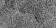
扇形地形 编辑
扇形地形在火星南北45°到60°之间的中纬度地区很常见,在北半球的乌托邦平原区[60][61]和南半球的佩纽斯和安菲特里忒火山口区尤为突出[62][63]。这种地形由带扇贝或荷叶边状口沿、无凸起壁垒环的浅洼地构成,通常称为“扇形洼地”或简称“扇形地形”。扇形洼地可能呈单独或聚集出现,有时似乎串联在一起。一处典型的扇形洼地显示为面向赤道的缓坡和面朝极地的峭壁,这种不对称地形可能是由于日照差异造成的。扇形洼地据认为是地下物质(可能是间隙冰)因升华消失而形成,这一过程目前可能仍在发生[64]。
2016年11月22日,美国宇航局报告称,在火星乌托邦平原地区发现了大量地下冰[65],据估计,检测到的水量相当于一座苏必利尔湖水量[66][67]。该地区的水冰容量是根据火星勘测轨道飞行器上的探地雷达仪,简称“沙拉德”(SHARAD)的测量结果确定的。根据从探地雷达获得的数据,测定的“电容率”或介电常数,介电常数值与大量聚集的水冰相一致[68][69][70]。2016年11月22日,美国宇航局报告称,在火星乌托邦平原地区发现了大量地下冰[65],检测到的水量相当于一座苏必利尔湖[66][67]。该地区的水冰容量是根据火星勘测轨道飞行器上的探地雷达仪,简称“沙拉德”(SHARAD)的测量结果确定的。根据从探地雷达获得的数据,测定的“电容率”或介电常数,介电常数值与大量聚集的水冰相一致[68][69][70]。
,
-
 扇形地面
扇形地面 -
 扇形地面特写,表面被划分成很多多边形,这类地貌在地表被冻结和融化的地区很常见。注意:这是先前图像的放大版。
 -
 扇形地面
扇形地面 -
 扇形地面表面被划分成很多多边形,这类地貌在地表被冻结和融化的地区很常见。注意:这是先前图像的放大版。
 -
 中央凹陷多边形地面, 带有显示箭头,图像被高分辨率成像科学设备放大。
 -
 卡西乌斯区的扇形地形。
 -
 卡西乌斯区的扇形地形。


底座形撞击坑 编辑
底座形撞击坑是一种喷出物在陨坑周围形成一座凸起平台(如基座)的撞击坑。当撞击坑喷出的物质形成一层耐侵蚀层后,它周围的区域受侵蚀速度会较其他区域更慢,由此就会形成一座基座。一些基座被精确测出高于周边区域数百米,意味着有数百米的材料被侵蚀掉了,结果使得陨石坑及其喷出物覆盖层都高耸于周边环境之上。底座形陨石坑是在水手号任务期间首次观测到的[71][72][73][74]。
,


环形模具陨石坑 编辑
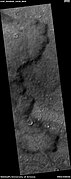
环模陨石坑被认为是由小行星撞击下面分布有冰层的地面所形成,撞击使冰层反弹,形成“环形模具”形状。
-
![伊斯墨诺斯湖区]]各种大小坑底的环形模具陨石坑。](//upload.wikimedia.org/wikipedia/commons/thumb/5/5a/ESP_037622_2200ringmoldfield.jpg/190px-ESP_037622_2200ringmoldfield.jpg) 伊斯墨诺斯湖区]]各种大小坑底的环形模具陨石坑。
伊斯墨诺斯湖区]]各种大小坑底的环形模具陨石坑。 -
 环形模具陨坑区广角视图
 -
 环形模具陨石坑近景,注:这是前一幅图像的放大版。
![伊斯墨诺斯湖区]]各种大小坑底的环形模具陨石坑。](/wiki/File:ESP_037622_2200ringmoldfield.jpg)


-
 大撞击坑坑底上的环形模具陨石坑全景图
 -
 环形模具陨石坑
 -
 环形模具陨石坑和脑纹地形近景


晕坑 编辑
-
![沿边缘密布着大量巨石的底座式撞击坑被称为“晕坑”[75]。](//upload.wikimedia.org/wikipedia/commons/thumb/7/78/ESP_044939_2390pedestalhalocrater.jpg/190px-ESP_044939_2390pedestalhalocrater.jpg) 沿边缘密布着大量巨石的底座式撞击坑被称为“晕坑”[75]。
沿边缘密布着大量巨石的底座式撞击坑被称为“晕坑”[75]。 -
 撞击坑左下侧边缘上的巨石近景图,方框区尺寸有足球场大,所以,巨石的大小大致相当于一辆汽车或一幢小屋。
 -
 位于撞击坑边缘的巨石近景,巨石的大小大致相当于一辆汽车或一幢小屋。
![沿边缘密布着大量巨石的底座式撞击坑被称为“晕坑”[75]。](/wiki/File:ESP_044939_2390pedestalhalocrater.jpg)


尘暴痕迹 编辑
尘暴痕迹可能非常美,起因可能是巨大尘暴吹去了火星表面鲜艳的尘埃,从而暴露出一些暗黑层所形成。火星上的尘暴已被从地面和轨道高空拍摄到,它们甚至还吹走了火星上两辆火星车太阳能电池板上的灰尘,从而大大延长了它们的使用寿命[76]。研究表明,尘暴痕迹模式每隔数月就会发生变化[77],一项结合了高分辨率立体相机(HRSC)和火星轨道器相机(MOC)数据的研究发现,火星上一些大型尘暴的直径为700米(2300英尺),持续时间至少有26分钟[78]。
-
 尘暴痕迹
尘暴痕迹 -
 尘暴痕迹
尘暴痕迹 -
 顶部显示有尘暴痕迹的丹尼尔森撞击坑地层照片,位置为欧克西亚沼区。
 -


雅丹地貌 编辑
雅丹地貌在火星上一些地区很常见,特别是在所谓的“梅杜莎槽沟层”中,这种地层被发现于亚马逊区和赤道附近[79]。它们是由风刮起的沙粒大小的颗粒作用形成,因此,雅丹地貌通常指示出形成时的风向[80]。由于雅丹地貌中很少出现撞击坑,因此被认为相对年轻[81]。
,


羽流和蜘蛛状结构 编辑
火星上某些时候,会发生黑色气体和尘埃喷发,风经常把它们吹成扇形或尾巴状。在冬季,大量积聚的霜冻,被直接冻结在由覆盖着数层尘埃和沙粒的水冰所构成的永久性极地冰盖表面。沉积物启始于一层布满尘埃的二氧化碳霜冻,在整个冬季,它们会重新结晶并变得更为致密。霜冻中的尘埃和沙粒慢慢下沉。到春季气温上升时,霜冻层已变成了一层约3英尺厚的半透明冰,覆盖在深色沙尘基底上。这层黑色的沙尘会吸收阳光,使水冰升华(直接气化),最后,大量气体积聚,压力逐惭升高。当发现一处薄弱点时,气体就会逸出并吹出尘埃,流速可达每小时100英里[82]。计算表明,喷出的羽流高达20-80米[83][84]有时也可在地表看到被称为“蜘蛛”的黑色通道[85][86][87],当这一过程发生时,表面似乎布满了黑点[82][88]。
现已提出许多想法来解释这些特征[89][90][91][92][93][94],这些特征可在下面的一些图片中看到。
-
 羽流广角视图,当放大后许多羽流显示为蜘蛛状结构。
 -
 羽流,箭头指示了一道双羽流,可能是风向变化所致。
 -
 长羽流
长羽流 -
 蜘蛛状结构
蜘蛛状结构 -
 羽流和蜘蛛状结构
 -
 羽流和蜘蛛状结构
 -
 羽流和蜘蛛状结构
 -
 羽流和蜘蛛状结构全景图
 -
 羽流和蜘蛛状结构


上部平原单元 编辑
在火星中纬度地区发现了一种被称为“上部平原单元”的50-100米厚覆盖层残余物,在研究都特罗尼勒斯桌山群(伊斯墨诺斯湖区)区时被首次发现,但其他地方也有出现。该类残余物由陨石坑中和沿桌山的一组倾斜层构成[95]。倾斜层的大小和形状可能各不相同,有些看起来像中美洲阿兹特克金字塔。
-
 陨石坑中的层状结构,可能曾是覆盖面积更大的层状单元残余物,这种单元由天空落下的冰核尘埃所构成,图片位置为希腊区。

-
 位于希腊区的倾斜层结构。
 -
 位于希腊区的倾斜层结构。
 -
 位于希腊区的倾斜层结构。
 -
 层状结构
层状结构 -
 伊斯墨诺斯湖区分布于桌山坡壁上的下倾层近景图。
 -
 伊斯墨诺斯湖区的下倾层近景图。
 -
 伊斯墨诺斯湖区下倾层广角图,在图像底部也可看到冲沟。


这种单元也会退化为脑纹地形,脑纹地形是一种3-5米高的迷宫状垄脊区。有些垄脊可能由冰核构成,因此它们可能是未来定居者的水源.
-
 伊斯墨诺斯湖区的脑纹地形。
 -
 层状特征和脑纹地形,上部平原单元经常会转变为脑纹地形。
 -
 脑纹地形正在从上部平原单元的解体中形成,箭头指向了即将转变为脑纹地形的破裂位置。
 -
 脑纹地形正在从上部平原单元的解体中形成,箭头指向了即将转变为脑纹地形的破裂位置。


-
 正在形成中的脑纹地形
 -
 正在形成中的脑纹地形,注:这是前一幅图像的放大版,箭头所指之处为脑纹地形开始形成的地方。
 -
 正在形成中的脑纹地形,注:这是前一幅图像的放大版,箭头所指之处为脑纹地形开始形成的地方。
 -
 正在形成中的脑纹地形,注:这是前一幅图像的放大版。
 -
 正在形成中的脑纹地形,注:这是前一幅图像的放大版。
 -
 带标注的开放闭合型脑纹地形,地点为伊斯墨诺斯湖区
 -
 伊斯墨诺斯湖区正在形成中的脑纹地形。


-
 正在形成中的脑纹地形近景图
 -
 正在形成中的脑纹地形,注:这是前一幅图像的放大版。
 -
 正在形成中的脑纹地形,注:这是前一幅图像的放大版。


上部平原单元的一些区域显示出大型裂缝和带凸起边缘的凹槽,这些地区被称为棱状上部平原(Ribbed Upper Plains)。据信断裂起始于应力引起的小裂缝,因为当碎屑堆聚集在一起或碎屑堆靠近边缘时,此类地点就会产生挤压应力,这在棱状上层平原很常见,应力则会引发断裂过程。裂缝暴露了更多的地表,因此地层中更多的冰升华到行星稀薄的大气层中。最终,小裂缝变成为大峡谷或大槽沟。
-
 发育良好的棱状上部平原地层,它们起始于一些表面小裂缝,并随着冰从裂缝中升华而进一步扩展开。
 -
 下倾层,在图片右上方可看到棱状上部平原地层,它们形成于上部平原单元,反过来又会被侵蚀成脑纹地形。


-
 显示棱状地形和脑纹地形的广角图
 -
 棱状地形形成于上部平原单元,起始于因冰升华而扩展开的地表裂缝,方框表示足球场大小的区域。


小裂缝通常包含小洞坑和洞坑链,这些被认为是由地表上的冰升华所形成[96][97]。火星表面大部分区域都蕴含了水冰,冰被一层1米厚的尘埃和其他物质所保护。然而,一旦出现地表缝,将会使水冰暴露在稀薄的大气层中,在很短时间内,冰将消失在寒冷稀薄的大气中[98][99],这一过程称为升华,干冰在地球上也有类似的行为。当凤凰号火星探测器发现裸露的冰块在几天内消失时,在火星上观察到了升华现象 [37][100]。此外,高分辨率成像科学设备还发现了底部有冰的新陨石坑。隔了一段时间,它曾看到的积冰就已消失无踪了[101]。
据认为,上层平原单元来自于天空中降落的物质,它覆盖在各种表面上,好像它均匀落下。与其他堆积覆盖层一样,上层平原单元具有层状、细粒度和富含冰,它分布普遍,似乎没有来源点。火星某些区域的表面外观是由于该单元的退化形成的,它也是造成舌状岩屑坡表面外观的主要原因[97]。据信,上部平原覆盖层单元和其他覆盖层单元的分层,是由该行星气候发生的重大变化所致。模型预测,随着地质时间推移,火星自转轴倾角或倾斜度可能会从目前的25度改变到超过80度。高倾斜期间将导致火星极地冰盖中的冰重新分布,并改变大气层中的灰尘含量[102][103][104]。
线性脊状网 编辑
在火星陨石坑内及周围不同地方都可以发现线性脊状网[105],这些脊线通常以格子形相交的直线形式出现,有数百米长,几十米高和数米宽。据认为,陨石撞击在地表形成了裂缝,这些裂缝后来充当了流体通道,流体使结构物胶结 。随着时间的推移,周围地层被侵蚀掉,留下这些坚硬的垄脊。
由于垄脊出现在有粘土的地方,这些地层可作为粘土的标志,而粘土的形成需要水,这里的水可以维持生命[106][107][108]。
-
 山脊网,山脊可以通过各种方式形成。
 -
 山脊彩色近景图,与一幅为同一图像。
 -
 线性脊线网彩色特写图
 -
 来自前一幅同一地区的更多线性脊线网。
 -
 亚马逊区线性脊线网。
 -
 第勒尼安海区线性脊线网。
 -
 卡西乌斯区线性脊线网。
 -
 阿耳卡狄亚区线性脊线网全景图。
 -
 阿耳卡狄亚区山脊网近景图,箭头指向小而直的山脊。


-
 脊线网全景图,后面的图像中放大了该图的部分区域。
 -
 脊线网近景图,前一幅图像的放大版。
 -
 脊线网近景图,前一幅图像的放大版,方框区面积相当于足球场大。
 -
 脊线网近景图,此为前一幅图像的放大版。
 -
 脊线网近景图,此为前一幅图像的放大版。 图像中有一座显示出分层结构的小桌山。
 -
 脊线网彩色近景图,此为前一幅图像的放大版。


-
 大型山脊线网全景图
 -
 脊线网近视图,方框区面积相当于足球场大。
 -
 脊线网彩色近景图。


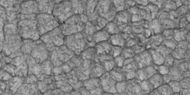
破碎地面 编辑
火星部分地区已破裂成桌山和山谷地形,其中一些可能相当壮观。
-
 断裂地面广角图
 -
 断裂地面近景图
 -
 破裂地面近景图,方框中区域相当于足球场大小,所以,这些巨石有房屋般大。
 -
 破裂地面彩色近景图。


桌山 编辑
-
 桌山,在遥远未来的某一天,可能会在一座桌山周围举行一场精彩的比赛。

-
 阿西达里亚海区桌山岩层
 -
 桌山岩层近景


-
-
 带有暗坡条纹的层状桌山和土墩
 -
 带暗坡条纹的层状小桌山近景图,方框中区域相当于足球场大小。
 -
 非常近距的单幅视图,从一座岩丘岩层中剥离出的巨石群。


地面塌陷形成的桌山 编辑
-
 桌山群,圆角方框中包含的可能是一些已剥离开的桌山。
 -
 放大的桌山群视图,其中一座的表面已形成四方形。
 -
 桌山断裂形成直边。


冰下火山 编辑
有证据表明,火山有时会在冰下喷发,就像地球上的一样。当火山喷发时,大量积冰融化为水逸出,随后使表面发生开裂并崩塌,呈现同心裂缝和好似被撑开的大块地面[109]。像这类地点最近可能曾存在过液态水,因此是很可能会寻找到生命证据的地方[110][111]。
-
![出现在伊斯墨诺斯湖区的大量同心裂缝,裂缝是由冰下火山喷发形成的[110]。](//upload.wikimedia.org/wikipedia/commons/thumb/9/93/25755concentriccracks.jpg/190px-25755concentriccracks.jpg)
-
 地面塌陷时形成的倾斜层
 -
 地面塌陷时形成的倾斜层
 -
 桌山断裂破碎成巨石块
![出现在伊斯墨诺斯湖区的大量同心裂缝,裂缝是由冰下火山喷发形成的[110]。](/wiki/File:25755concentriccracks.jpg)


断裂块体 编辑
在一些地方,大型裂缝会使表层破裂,有时裂缝会形成直边和大立方体巨岩。
-
 正在形成裂缝的桌山全景图。
 -
 前一幅图像的放大片,矩形表示足球场般大小。
 -
 正在形成中的巨石块特写。
 -
 正在剥落的巨石块特写,矩形表示足球场般大小,所以巨石尺寸如有建筑物大。
 -
 正在剥落中的巨石块特写,表面可看到很多长裂缝。
 -
 破裂地表,靠近图像顶部的地表正被侵蚀成脑纹地形。
 -
 显示破裂为巨石块的浅色特征全景图。
 -
 显示正在剥落中的巨石块近景图,注意:这是前一幅图像的放大版,方框中区域代表足球场般大小。


熔岩流 编辑
-
 塔尔西斯区的熔岩流
 -
 带标注的熔岩流特写,这是前一幅熔岩流图像的放大。
 -
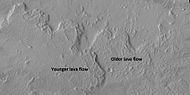 标注出了古老和较年轻的熔岩流。
 -
-
 流线体状熔岩和熔岩筏全景图
 -
 前一幅图像中的熔岩筏近景图。


无根火山锥 编辑
所谓的“无根火山锥”产生于下方有地面冰的熔岩流爆炸[112][113]。冰被熔岩流融化变成蒸汽,在爆炸中膨胀,形成圆锥体或圆环。在冰岛也发现了熔岩覆盖在被水浸透的基底上而产生的类似特征[114][112][115]。


泥火山 编辑
有些看起来像火山的特征中,有一些可能是泥火山,受压的泥浆被迫向上拱起形成锥体。这些特征可能是寻找生命的地方,因为它们将可能的生命带到地表,并保护了它们免遭辐射的破坏。
-
 可能为泥火山的大型火山锥场,位置为阿西达里亚海区。
 -
 可能的泥火山特写,注意:这是前一幅图像的放大版。


-
 阿西达里亚海区的泥火山,在该区域有很多的泥火山。
 -
 阿西达里亚海区可能的泥火山。


-
 泥火山群全景图
 -
 泥火山群近景
 -
 泥火山和巨石近景图


希腊平原地表特征 编辑
在希腊平原的部分地面上发现了一些奇怪的地形,科学家们尚无法确定它们是如何形成的。
-
 希腊平原地表上的扭曲带
 -
 希腊平原地表特征
 -
 希腊平原地表特征
 -
 希腊地表上的山脊群近景


被掘出的陨坑 编辑
被掘出陨坑似乎是被重新揭露出来的[116],据信,它们形成后被掩埋,而现在正随着地层的侵蚀,被重新挖掘出来。陨石坑形成时,会摧毁它下面的结构。在下面的示例中,只能看到陨坑的一部分。如果陨石坑形成于分层特征后,它将会撞毁掉下方的部分特征,我们将能看到整个陨石坑。
-
 被掘出陨石坑全景图
 -
 被掘出陨石坑近景图,该陨石坑现在和过去都位于一系列倾斜层之下。


如何建议要拍摄的图像 编辑
要推荐高分辨率成像科学设备拍摄图像的位置,请访问以下站点:http://www.uahirise.org/hiwish (页面存档备份,存于互联网档案馆)
在注册时,需要您提供身份识别号(ID)和密码。当你选择要成像的目标时,必须先在地图上选择一处准确的位置,并写下为何要拍摄该图像。如果你的建议被接受,可能需要3个月或更长时间才能看到你要的照片。您将会收到一封有关您建议图像的电子邮件。电子邮件通常在每月的第一个星期三下午稍晚时到达。
另请参阅 编辑
参考文献 编辑
- ^ Public Invited To Pick Pixels On Mars. Mars Daily. January 22, 2010 [January 10, 2011]. (原始内容存档于2013-05-23).
- ^ 存档副本. [2021-08-05]. (原始内容存档于2021-08-05).
- ^ 存档副本. [2021-08-05]. (原始内容存档于2019-09-08).
- ^ Interview with Alfred McEwen on Planetary Radio, 3/15/2010
- ^ Your Personal Photoshoot on Mars?. www.planetary.org. [20 November 2018]. (原始内容存档于2019-08-31).
- ^ NASA releases first eight "HiWish" selections of people's choice Mars images. TopNews. April 2, 2010 [January 10, 2011]. (原始内容存档于May 23, 2013).
- ^ McEwen, A. et al. 2016. THE FIRST DECADE OF HIRISE AT MARS. 47th Lunar and Planetary Science Conference (2016) 1372.pdf
- ^ Milliken, R.; Mustard, J.; Goldsby, D. Viscous flow features on the surface of Mars: Observations from high-resolution Mars Orbiter Camera (MOC) images. J. Geophys. Res. 2003, 108. Bibcode:2003JGRE..108.5057M. doi:10.1029/2002JE002005.
- ^ Arfstrom, J; Hartmann, W. Martian flow features, moraine-like ridges, and gullies: Terrestrial analogs and interrelationships. Icarus. 2005, 174: 321–335. Bibcode:2005Icar..174..321A. doi:10.1016/j.icarus.2004.05.026.
- ^ Hubbard, B.; Milliken, R.; Kargel, J.; Limaye, A.; Souness, C. Geomorphological characterisation and interpretation of a mid-latitude glacier-like form: Hellas Planitia, Mars. Icarus. 2011, 211: 330–346. Bibcode:2011Icar..211..330H. doi:10.1016/j.icarus.2010.10.021.
- ^ HiRISE - Spider Webs (ESP_046359_1250). www.uahirise.org. [20 November 2018]. (原始内容存档于2016-10-27).
- ^ Soare, E., et al. 2019. Possible (closed system) pingo and ice-wedge/thermokarst complexes at the mid latitudes of Utopia Planitia, Mars. Icarus. https://doi.org/10.1016/j.icarus.2019.03.010
- ^ Baker, V. 1982. The Channels of Mars. Univ. of Tex. Press, Austin, TX
- ^ NASA.gov. [2021-08-05]. (原始内容存档于2013-02-14).
- ^ HiRISE - Candidate Landing Site for 2020 Mission in Firsoff Crater (ESP_039404_1820). hirise.lpl.arizona.edu. [20 November 2018]. (原始内容存档于2022-03-19).
- ^ Pondrelli, M., A. Rossi, L. Deit, S. van Gasselt, F. Fueten, E. Hauber, B. Cavalazzi, M. Glamoclija, and F. Franchi. 2014. A PROPOSED LANDING SITE FOR THE 2020 MARS MISSION: FIRSOFF CRATER. http://marsnext.jpl.nasa.gov/workshops/2014_05/33_Pondrelli_Firsoff_LS2020.pdf (页面存档备份,存于互联网档案馆)
- ^ Golombek, J. et al. 2016. Downselection of landing Sites for the Mars 2020 Rover Mission. 47th Lunar and Planetary Science Conference (2016). 2324.pdf
- ^ McEwen, A.; et al. Recurring slope lineae in equatorial regions of Mars. Nature Geoscience. 2014, 7: 53–58. doi:10.1038/ngeo2014.
- ^ McEwen, A.; et al. Seasonal Flows on Warm Martian Slopes. Science. 2011, 333 (6043): 740–743. Bibcode:2011Sci...333..740M. PMID 21817049. doi:10.1126/science.1204816.
- ^ recurring slope lineae - Red Planet Report. redplanet.asu.edu. [20 November 2018]. (原始内容存档于2017-09-04).
- ^ 存档副本. [2021-08-05]. (原始内容存档于2021-02-05).
- ^ Bishop, J., et al. 2021. Martian subsurface cryosalt expansion and collapse as trigger for landslides. Science Advances. Vol. 7, no. 6, eabe4459 DOI: 10.1126/sciadv.abe4459
- ^ 存档副本. [2021-08-05]. (原始内容存档于2021-12-27).
- ^ HiRISE | High Resolution Imaging Science Experiment. Hirise.lpl.arizona.edu?psp_008437_1750. [2012-08-04]. (原始内容存档于2017-08-08).
- ^ Malin, M.; Edgett, K. Evidence for recent groundwater seepage and surface runoff on Mars. Science. 2000, 288: 2330–2335. Bibcode:2000Sci...288.2330M. PMID 10875910. doi:10.1126/science.288.5475.2330.
- ^ 26.0 26.1 Hecht, M. Metastability of water on Mars. Icarus. 2002, 156: 373–386. Bibcode:2002Icar..156..373H. doi:10.1006/icar.2001.6794.
- ^ 27.0 27.1 Mustard, J.; et al. Evidence for recent climate change on Mars from the identification of youthful near-surface ground ice. Nature. 2001, 412 (6845): 411–414. Bibcode:2001Natur.412..411M. PMID 11473309. doi:10.1038/35086515.
- ^ Pollack, J.; Colburn, D.; Flaser, F.; Kahn, R.; Carson, C.; Pidek, D. Properties and effects of dust suspended in the martian atmosphere. J. Geophys. Res. 1979, 84: 2929–2945. Bibcode:1979JGR....84.2929P. doi:10.1029/jb084ib06p02929.
- ^ HiRISE - Layered Mantling Deposits in the Northern Mid-Latitudes (ESP_048897_2125). www.uahirise.org. [20 November 2018]. (原始内容存档于2017-09-02).
- ^ Boynton, W.; et al. Distribution of hydrogen in the nearsurface of Mars: Evidence for sub-surface ice deposits. Science. 2002, 297: 81–85. Bibcode:2002Sci...297...81B. PMID 12040090. doi:10.1126/science.1073722.
- ^ Kuzmin, R; et al. Regions of potential existence of free water (ice) in the near-surface martian ground: Results from the Mars Odyssey High-Energy Neutron Detector (HEND). Solar System Research. 2004, 38 (1): 1–11. doi:10.1023/b:sols.0000015150.61420.5b.
- ^ Mitrofanov, I. et al. 2007a. Burial depth of water ice in Mars permafrost subsurface. In: LPSC 38, Abstract #3108. Houston, TX.
- ^ Mitrofanov, I.; et al. Water ice permafrost on Mars: Layering structure and subsurface distribution according to HEND/Odyssey and MOLA/MGS data. Geophys. Res. Lett. 2007b, 34: 18. doi:10.1029/2007GL030030.
- ^ Mangold, N.; et al. Spatial relationships between patterned ground and ground ice detected by the neutron spectrometer on Mars. J. Geophys. Res. 2004, 109: E8. doi:10.1029/2004JE002235.
- ^ Feldman, W.; et al. Global distribution of neutrons from Mars: Results from Mars Odyssey. Science. 2002, 297: 75–78. Bibcode:2002Sci...297...75F. PMID 12040088. doi:10.1126/science.1073541.
- ^ Feldman, W.; et al. North to south asymmetries in the water-equivalent hydrogen distribution at high latitudes on Mars. J. Geophys. Res. 2008, 113. doi:10.1029/2007JE003020.
- ^ 37.0 37.1 Bright Chunks at Phoenix Lander's Mars Site Must Have Been Ice (页面存档备份,存于互联网档案馆) – Official NASA press release (19.06.2008)
- ^ Confirmation of Water on Mars. Nasa.gov. 2008-06-20 [2012-07-13]. (原始内容存档于2008-07-01).
- ^ Mutch, T.A., and 24 colleagues, 1976. The surface of Mars: The view from the Viking2 lander Science 194 (4271), 1277–1283.
- ^ Mutch, T.; et al. The geology of the Viking Lander 2 site. J. Geophys. Res. 1977, 82: 4452–4467. Bibcode:1977JGR....82.4452M. doi:10.1029/js082i028p04452.
- ^ Levy, J.; et al. Thermal contraction crack polygons on Mars: Classification, distribution, and climate implications from HiRISE observations. J. Geophys. Res. 2009, 114. Bibcode:2009JGRE..114.1007L. doi:10.1029/2008JE003273.
- ^ Washburn, A. 1973. Periglacial Processes and Environments. St. Martin's Press, New York, pp. 1–2, 100–147.
- ^ Mellon, M. 1997. Small-scale polygonal features on Mars: Seasonal thermal contraction cracks in permafrost J. Geophys. Res. 102, 25,617-25,628.
- ^ 44.0 44.1 Mangold, N. High latitude patterned grounds on Mars: Classification, distribution and climatic control. Icarus. 2005, 174: 336–359. Bibcode:2005Icar..174..336M. doi:10.1016/j.icarus.2004.07.030.
- ^ Marchant, D.; Head, J. Antarctic dry valleys: Microclimate zonation, variable geomorphic processes, and implications for assessing climate change on Mars. Icarus. 2007, 192: 187–222. Bibcode:2007Icar..192..187M. doi:10.1016/j.icarus.2007.06.018.
- ^ Refubium - Suche (PDF). www.diss.fu-berlin.de. [20 November 2018]. (原始内容 (PDF)存档于2017-08-14).
- ^ Kostama, V.-P.; Kreslavsky, Head. Recent high-latitude icy mantle in the northern plains of Mars: Characteristics and ages of emplacement. Geophys. Res. Lett. 2006, 33: L11201. doi:10.1029/2006GL025946.K.
- ^ Malin, M.; Edgett, K. Mars Global Surveyor Mars Orbiter Camera: Interplanetary cruise through primary mission. J. Geophys. Res. 2001, 106 (E10): 23429–23540. Bibcode:2001JGR...10623429M. doi:10.1029/2000je001455.
- ^ Milliken, R.; et al. Viscous flow features on the surface of Mars: Observations from high-resolution Mars Orbiter Camera (MOC) images. J. Geophys. Res. 2003, 108: E6. Bibcode:2003JGRE..108.5057M. doi:10.1029/2002JE002005.
- ^ Kreslavsky, M.; Head, J. Kilometer-scale roughness on Mars: Results from MOLA data analysis. J. Geophys. Res. 2000, 105 (E11): 26695–26712. Bibcode:2000JGR...10526695K. doi:10.1029/2000je001259.
- ^ Seibert, N.; Kargel, J. Small-scale martian polygonal terrain: Implications for liquid surface water. Geophys. Res. Lett. 2001, 28 (5): 899–902. Bibcode:2001GeoRL..28..899S. doi:10.1029/2000gl012093.
- ^ Kreslavsky, M.A., Head, J.W., 2002. High-latitude Recent Surface Mantle on Mars: New Results from MOLA and MOC. European Geophysical Society XXVII, Nice.
- ^ Head, J.W.; Mustard, J.F.; Kreslavsky, M.A.; Milliken, R.E.; Marchant, D.R. Recent ice ages on Mars. Nature. 2003, 426 (6968): 797–802. Bibcode:2003Natur.426..797H. PMID 14685228. doi:10.1038/nature02114.
- ^ Steep Slopes on Mars Reveal Structure of Buried Ice (页面存档备份,存于互联网档案馆). NASA Press Release. 11 January 2018.
- ^ Ice cliffs spotted on Mars (页面存档备份,存于互联网档案馆). Science News. Paul Voosen. 11 January 2018.
- ^ Exposed subsurface ice sheets in the Martian mid-latitudes. www.slideshare.net. [20 November 2018]. (原始内容存档于2021-08-05).
- ^ Steep Slopes on Mars Reveal Structure of Buried Ice - SpaceRef. spaceref.com. [20 November 2018].[失效連結]
- ^ Dundas, Colin M.; et al. Exposed subsurface ice sheets in the Martian mid-latitudes. Science. 2018, 359 (6372): 199–201. Bibcode:2018Sci...359..199D. PMID 29326269. doi:10.1126/science.aao1619.
- ^ 59.0 59.1 Supplementary Materials Exposed subsurface ice sheets in the Martian mid-latitudes Colin M. Dundas, Ali M. Bramson, Lujendra Ojha, James J. Wray, Michael T. Mellon, Shane Byrne, Alfred S. McEwen, Nathaniel E. Putzig, Donna Viola, Sarah Sutton, Erin Clark, John W. Holt
- ^ Lefort, A.; Russell, P. S.; Thomas, N.; McEwen, A. S.; Dundas, C. M.; Kirk, R. L. Observations of periglacial landforms in Utopia Planitia with the High Resolution Imaging Science Experiment (HiRISE). Journal of Geophysical Research. 2009, 114 (E4): E04005. Bibcode:2009JGRE..114.4005L. doi:10.1029/2008JE003264.
- ^ Morgenstern, A; Hauber, E; Reiss, D; van Gasselt, S; Grosse, G; Schirrmeister, L. Deposition and degradation of a volatile-rich layer in Utopia Planitia, and implications for climate history on Mars (PDF). Journal of Geophysical Research: Planets. 2007, 112 (E6): E06010. Bibcode:2007JGRE..112.6010M. doi:10.1029/2006JE002869. (原始内容 (PDF)存档于2011-10-04).
- ^ Lefort, A.; Russell, P.S.; Thomas, N. Scalloped terrains in the Peneus and Amphitrites Paterae region of Mars as observed by HiRISE. Icarus. 2010, 205 (1): 259. Bibcode:2010Icar..205..259L. doi:10.1016/j.icarus.2009.06.005.
- ^ Zanetti, M.; Hiesinger, H.; Reiss, D.; Hauber, E.; Neukum, G. Scalloped Depression Development on Malea Planum and the Southern Wall of the Hellas Basin, Mars (PDF). Lunar and Planetary Science. 2009, 40. p. 2178, abstract 2178 [2021-08-05]. Bibcode:2009LPI....40.2178Z. (原始内容 (PDF)存档于2016-06-16).
- ^ http://hiroc.lpl.arizona.edu/images/PSP?diafotizo.php?ID=PSP_002296_1215[永久失效連結]
- ^ Huge Underground Ice Deposit on Mars Is Bigger Than New Mexico. [20 November 2018]. (原始内容存档于2018-01-12).
- ^ Staff. Scalloped Terrain Led to Finding of Buried Ice on Mars. NASA. November 22, 2016 [November 23, 2016]. (原始内容存档于2018-12-26).
- ^ Lake of frozen water the size of New Mexico found on Mars – NASA. The Register. November 22, 2016 [November 23, 2016]. (原始内容存档于2018-12-26).
- ^ Bramson, A, et al. 2015. Widespread excess ice in Arcadia Planitia, Mars. Geophysical Research Letters: 42, 6566-6574
- ^ Archived copy. [2016-11-29]. (原始内容存档于2016-11-30).
- ^ Stuurman, C., et al. 2016. SHARAD detection and characterization of subsurface water ice deposits in Utopia Planitia, Mars. Geophysical Research Letters: 43, 9484_9491.
- ^ http://hirise.lpl.eduPSP_008508_1870[永久失效連結]
- ^ Bleacher, J. and S. Sakimoto. Pedestal Craters, A Tool For Interpreting Geological Histories and Estimating Erosion Rates. LPSC
- ^ Archived copy. [2010-03-26]. (原始内容存档于2010-01-18).
- ^ McCauley, J. F. Mariner 9 evidence for wind erosion in the equatorial and mid-latitude regions of Mars. Journal of Geophysical Research. 1973, 78 (20): 4123–4137. Bibcode:1973JGR....78.4123M. doi:10.1029/JB078i020p04123.
- ^ Levy, J. et al. 2008. Origin and arrangement of boulders on the martian northern plains: Assessment of emplacement and modification environments> In 39th Lunar and Planetary Science Conference, Abstract #1172. League City, TX
- ^ Mars Exploration Rover Mission: Press Release Images: Spirit (页面存档备份,存于互联网档案馆). Marsrovers.jpl.nasa.gov. Retrieved on 7 August 2011.
- ^ HiRISE - Dust Devils Dancing on Dunes (PSP_005383_1255). hirise.lpl.arizona.edu. [20 November 2018]. (原始内容存档于2018-01-09).
- ^ Reiss, D.; et al. Multitemporal observations of identical active dust devils on Mars with High Resolution Stereo Camera (HRSC) and Mars Orbiter Camera (MOC). Icarus. 2011, 215: 358–369. Bibcode:2011Icar..215..358R. doi:10.1016/j.icarus.2011.06.011.
- ^ Ward, A. Wesley. Yardangs on Mars: Evidence of recent wind erosion. Journal of Geophysical Research. 20 November 1979, 84 (B14): 8147. Bibcode:1979JGR....84.8147W. doi:10.1029/JB084iB14p08147.
- ^ esa. 'Yardangs' on Mars. [20 November 2018]. (原始内容存档于2019-09-06).
- ^ Medusae Fossae Formation - Mars Odyssey Mission THEMIS. themis.asu.edu. [20 November 2018]. (原始内容存档于2017-08-29).
- ^ 82.0 82.1 Gas jets spawn dark 'spiders' and spots on Mars icecap - Mars Odyssey Mission THEMIS. themis.asu.edu. [20 November 2018]. (原始内容存档于2017-08-09).
- ^ Thomas, N., G. Portyankina, C.J. Hansen, A. Pommerol. 2011. HiRISE observations of gas sublimation-driven activity in Mars' southern polar regions: IV. Fluid dynamics models of CO2 jets Icarus: 212, pp. 66–85
- ^ Buhler, Peter, Andrew Ingersoll, Bethany Ehlmann, Cale Fassett, James Head. 2017. How the martian residual south polar cap develops quasi-circular and heart-shaped pits, troughs, and moats. Icarus: 286, 69–93
- ^ Benson, M. 2012. Planetfall: New Solar System Visions
- ^ Spiders invade Mars. Astrobiology Magazine. 17 August 2006 [20 November 2018]. (原始内容存档于2016-08-23).
- ^ Kieffer H, Christensen P, Titus T. 2006 Aug 17. CO2 jets formed by sublimation beneath translucent slab ice in Mars' seasonal south polar ice cap. Nature: 442(7104):793-6.
- ^ Thawing 'Dry Ice' Drives Groovy Action on Mars. NASA/JPL. [20 November 2018]. (原始内容存档于2016-12-29).
- ^ Kieffer, H. H. Mars Polar Science 2000 - Annual Punctuated CO2 Slab-ice and Jets on Mars. (PDF). 2000 [6 September 2009]. (原始内容 (PDF)存档于2011-08-21).
- ^ Kieffer, Hugh H. Third Mars Polar Science Conference (2003)- Behavior of Solid CO (PDF). 2003 [6 September 2009]. (原始内容 (PDF)存档于2021-02-25).
- ^ Portyankina, G. (编). Fourth Mars Polar Science Conference - Simulations of Geyser-Type Eruptions in Cryptic Region of Martian South (PDF). 2006 [11 August 2009]. (原始内容 (PDF)存档于2012-02-17).
- ^ Sz. Bérczi; et al (编). Lunar and Planetary Science XXXV (2004) - Stratigraphy of Special Layers – Transient Ones on Permeable Ones: Examples (PDF). 2004 [12 August 2009]. (原始内容 (PDF)存档于2017-07-06).
- ^ NASA Findings Suggest Jets Bursting From Martian Ice Cap. Jet Propulsion Laboratory (NASA). 16 August 2006 [11 August 2009]. (原始内容存档于2009-10-10).
- ^ C.J. Hansen; N. Thomas; G. Portyankina; et al. HiRISE observations of gas sublimation-driven activity in Mars' southern polar regions: I. Erosion of the surface (PDF). Icarus. 2010, 205 (1): 283–295 [26 July 2010]. Bibcode:2010Icar..205..283H. doi:10.1016/j.icarus.2009.07.021. (原始内容 (PDF)存档于2016-03-03).
- ^ Carr, M. 2001.
- ^ Morgenstern, A., et al. 2007
- ^ 97.0 97.1 Baker, D.; Head, J. Extensive Middle Amazonian mantling of debris aprons and plains in Deuteronilus Mensae, Mars: Implication for the record of mid-latitude glaciation. Icarus. 2015, 260: 269–288. doi:10.1016/j.icarus.2015.06.036.
- ^ Mangold, N. Geomorphic analysis of lobate debris aprons on Mars at Mars Orbiter Camera scale: Evidence for ice sublimation initiated by fractures. J. Geophys. Res. 2003, 108: 8021. Bibcode:2003JGRE..108.8021M. doi:10.1029/2002je001885.
- ^ Levy, J. et al. 2009. Concentric
- ^ NASA - Bright Chunks at Phoenix Lander's Mars Site Must Have Been Ice. www.nasa.gov. [20 November 2018]. (原始内容存档于2016-03-04).
- ^ Byrne, S.; et al. Distribution of Mid-Latitude Ground Ice on Mars from New Impact Craters. Science. 2009, 325: 1674–1676. Bibcode:2009Sci...325.1674B. PMID 19779195. doi:10.1126/science.1175307.
- ^ Head, J. et al. 2003.
- ^ Madeleine, et al. 2014.
- ^ Schon; et al. A recent ice age on Mars: Evidence for climate oscillations from regional layering in mid-latitude mantling deposits. Geophys. Res. Lett. 2009, 36: L15202.
- ^ Head, J.; Mustard, J. Breccia dikes and crater-related faults in impact craters on Mars: Erosion and exposure on the floor of a crater 75 km in diameter at the dichotomy boundary. Meteorit. Planet Science. 2006, 41: 1675–1690. doi:10.1111/j.1945-5100.2006.tb00444.x.
- ^ Mangold; et al. Mineralogy of the Nili Fossae region with OMEGA/Mars Express data: 2. Aqueous alteration of the crust. J. Geophys. Res. 2007, 112. Bibcode:2007JGRE..112.8S04M. doi:10.1029/2006JE002835.
- ^ Mustard; et al. Mineralogy of the Nili Fossae region with OMEGA/Mars Express data: 1. Ancient impact melt in the Isidis Basin and implications for the transition from the Noachian to Hesperian. J. Geophys. Res. 2007. doi:10.1029/2006JE002834.
- ^ Mustard; et al. Composition, Morphology, and Stratigraphy of Noachian Crust around the Isidis Basin. J. Geophys. Res. 2009, 114. Bibcode:2009JGRE..114.0D12M. doi:10.1029/2009JE003349.
- ^ Smellie, J., B. Edwards. 2016. Glaciovolcanism on Earth and Mars. Cambridge University Press.
- ^ 110.0 110.1 Levy, J., et al. 2017. Candidate volcanic and impact-induced ice depressions on Mars. Icarus: 285, 185-194.
- ^ University of Texas at Austin. "A funnel on Mars could be a place to look for life." ScienceDaily. ScienceDaily, 10 November 2016. <www.sciencedaily.com/releases/2016/11/161110125408.htm>.
- ^ 112.0 112.1 PSR Discoveries: Rootless cones on Mars. www.psrd.hawaii.edu. [20 November 2018]. (原始内容存档于2016-08-09).
- ^ Lanagan, P., A. McEwen, L. Keszthelyi, and T. Thordarson. 2001. Rootless cones on Mars indicating the presence of shallow equatorial ground ice in recent times, Geophysical Research Letters: 28, 2365-2368.
- ^ S. Fagents1, a., P. Lanagan, R. Greeley. 2002. Rootless cones on Mars: a consequence of lava-ground ice interaction. Geological Society, Londo. Special Publications: 202, 295-317.
- ^ Jaeger, W., L. Keszthelyi, A. McEwen, C. Dundas, P. Russell, and the HiRISE team. 2007. EARLY HiRISE OBSERVATIONS OF RING/MOUND LANDFORMS IN ATHABASCA VALLES, MARS. Lunar and Planetary Science XXXVIII 1955.pdf.
- ^ https://archive.org/details/PLAN-PIA06808
延伸阅读 编辑
- Lorenz, R. 2014. The Dune Whisperers. The Planetary Report: 34, 1, 8-14
- Lorenz, R., J. Zimbelman. 2014. Dune Worlds: How Windblown Sand Shapes Planetary Landscapes. Springer Praxis Books / Geophysical Sciences.
- Grotzinger, J. and R. Milliken (eds.). 2012. Sedimentary Geology of Mars. SEPM.
外部链接 编辑
- HiRISE images from HiWish Program (页面存档备份,存于互联网档案馆)
- /0:48 Zooming in on Mars with HiRISE images from HiWish program (页面存档备份,存于互联网档案馆)
- Features of Mars with HiRISE under HiWish program (页面存档备份,存于互联网档案馆) Shows nearly all major features discovered on Mars. This would be good for teachers covering Mars.
- A trip to Mars with Hubble, Viking, and HiRISE (页面存档备份,存于互联网档案馆)
- Mars through HiRISE under the HiWish program (页面存档备份,存于互联网档案馆)
- Beautiful Mars as seen by HiRISE under HiWish program (页面存档备份,存于互联网档案馆)
- Martian Ice - Jim Secosky - 16th Annual International Mars Society Convention (页面存档备份,存于互联网档案馆)
- https://www.youtube.com/watch?v=RYG-HLr33CM (页面存档备份,存于互联网档案馆) Martian Geology - Jim Secosky - 16th Annual International Mars Society Convention
- https://www.youtube.com/watch?v=ZNTNzQy1_UA (页面存档备份,存于互联网档案馆) Walks on Mars - Jim Secosky - 16th Annual International Mars Society Convention
- https://www.youtube.com/watch?v=0fQHEay-Yas&list=PLn0lnGc1Saik-yyWpeec3AWz9NgdtxDAF&index=122 (页面存档备份,存于互联网档案馆) How to Explore Mars without Leaving Your Chair - Jim Secosky - 23rd Annual Mars Society Convention