File:Luwian Language de.svg

此 SVG 檔案的 PNG 預覽的大小:638 × 599 像素。 其他解析度:256 × 240 像素 | 511 × 480 像素 | 818 × 768 像素 | 1,090 × 1,024 像素 | 2,181 × 2,048 像素 | 790 × 742 像素。
原始檔案 (SVG 檔案,表面大小:790 × 742 像素,檔案大小:308 KB)
| 描述 |
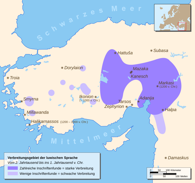
English: Map of a part of Eastern Europe/Asia with spreading of the Luwian Language
Deutsch: Karte mit Teilen Ost-Europas/Asiens mit dem Verbreitungsgebiet der luwischen Sprache |
| 日期 | |
| 來源 |
Drawn by myself, based on different source maps: Continental outlines (by San Jose), Luwian Language spreading (by Enlil2), Cities, Locator map Enlil2 extracted the data from the book “The Luwians” (H. Craig Melchert, Brill 2003) |
| 作者 | Hendrik Tammen (Enricopedia ⇄) |
| 授權許可 (重用此檔案) |
Author |
| 其他版本 |
|


English: German translation of the city-names Deutsch: Übersetzung der Städtenamen
| ||
|---|---|---|
English: Ancient name Deutsch: Altertümlicher Name |
English: First settlements / City founded Deutsch: Erste Besiedlung / Stadtgründung |
English: Modern German name Deutsch: Heutiger Name
|
| Adanija | founded by Hittites | Adana |
| Damaskus | first settlements 5000 BC | Damaskus |
| Dorylaion (gr.) | founded by Hittites | Eskişehir |
| Halikarnassos (gr.) | founded 1200 – 1000 BC by Dorian Greeks | Bodrum |
| Halpa | first settlements 1900 BC | Aleppo |
| Hattuša | first settlements 6000 BC | Hattuša |
| Ikonion (gr.) | founded about 1000 BC | Konya |
| Kanesch | founded 1900 BC by Hittites | Kanesch |
| Markasi | founded 1200 BC | Kahramanmaras |
| Mazaka | founded by Hittites | Kayseri |
| Millawanda | founded about 3300 BC | Milet |
| Smyrna (gr.) | first settlements 10000 – 8000 BC | İzmir |
| Subasa | first settlements 7000 – 5000 BC | Sivas |
| Tarsos (gr.) | first settlements 4000 BC | Tarsus (lat.) |
| Troia / Τροία (gr.) | first settlements 3000 BC | Troja |
| Zephyrion (gr.) | founded 1500 – 1400 BC | Mersin |

|
This SVG file contains embedded text that can be translated into your language, using any capable SVG editor, text editor or the SVG Translate tool. For more information see: About translating SVG files. |

|
|
此檔案採用創用CC 姓名標示 2.5 通用版授權條款。
- 您可以自由:
- 分享 – 複製、發佈和傳播本作品
- 重新修改 – 創作演繹作品
- 惟需遵照下列條件:
- 姓名標示 – 您必須指名出正確的製作者,和提供授權條款的連結,以及表示是否有對內容上做出變更。您可以用任何合理的方式來行動,但不得以任何方式表明授權條款是對您許可或是由您所使用。
檔案歷史
點選日期/時間以檢視該時間的檔案版本。
| 日期/時間 | 縮圖 | 尺寸 | 使用者 | 備註 | |
|---|---|---|---|---|---|
| 目前 | 2007年1月9日 (二) 22:22 | | 790 × 742(308 KB) | Enricopedia | preview bugfix again |
| 2007年1月8日 (一) 15:39 |  | 790 × 742(308 KB) | Enricopedia | Hattusa => Hattuša | |
| 2007年1月4日 (四) 22:49 |  | 790 × 742(308 KB) | Enricopedia | changed some names | |
| 2007年1月4日 (四) 02:57 |  | 790 × 742(310 KB) | Enricopedia | changed map design, using only ancient city names and showing only ancient cities | |
| 2007年1月2日 (二) 20:49 |  | 790 × 742(300 KB) | Enricopedia | removed borders from the locator map | |
| 2007年1月1日 (一) 18:54 |  | 790 × 742(433 KB) | Enricopedia | preview bugfix | |
| 2007年1月1日 (一) 17:38 |  | 790 × 742(433 KB) | Enricopedia | added lakes, coast-lines and dates; code optimized | |
| 2006年12月26日 (二) 15:41 |  | 790 × 742(428 KB) | Enricopedia | typo changes | |
| 2006年12月23日 (六) 16:57 |  | 790 × 742(428 KB) | Enricopedia | added scale bar | |
| 2006年12月23日 (六) 14:22 |  | 790 × 742(420 KB) | Enricopedia | typography changes |
檔案用途
下列頁面有用到此檔案:
全域檔案使用狀況
以下其他 wiki 使用了這個檔案:
- ar.wikipedia.org 的使用狀況
- ast.wikipedia.org 的使用狀況
- azb.wikipedia.org 的使用狀況
- az.wikipedia.org 的使用狀況
- be-tarask.wikipedia.org 的使用狀況
- be.wikipedia.org 的使用狀況
- bg.wikipedia.org 的使用狀況
- bn.wikipedia.org 的使用狀況
- br.wikipedia.org 的使用狀況
- ca.wikipedia.org 的使用狀況
- de.wikipedia.org 的使用狀況
- diq.wikipedia.org 的使用狀況
- dsb.wikipedia.org 的使用狀況
- el.wikipedia.org 的使用狀況
- es.wikipedia.org 的使用狀況
- et.wikipedia.org 的使用狀況
- eu.wikipedia.org 的使用狀況
- fa.wikipedia.org 的使用狀況
- fi.wikipedia.org 的使用狀況
- fr.wikipedia.org 的使用狀況
- gl.wikipedia.org 的使用狀況
- he.wikipedia.org 的使用狀況
- hr.wikipedia.org 的使用狀況
- hu.wikipedia.org 的使用狀況
- id.wikipedia.org 的使用狀況
- it.wikipedia.org 的使用狀況
- ko.wikipedia.org 的使用狀況
- lfn.wikipedia.org 的使用狀況
- lt.wikipedia.org 的使用狀況
- mk.wikipedia.org 的使用狀況
- ml.wikipedia.org 的使用狀況
- mzn.wikipedia.org 的使用狀況
- nn.wikipedia.org 的使用狀況
- no.wikipedia.org 的使用狀況
- pl.wikipedia.org 的使用狀況
- pt.wikipedia.org 的使用狀況
- ru.wikipedia.org 的使用狀況
檢視此檔案的更多全域使用狀況。