File:NYCS map 3.svg

此 SVG 檔案的 PNG 預覽的大小:490 × 599 像素。 其他解析度:196 × 240 像素 | 393 × 480 像素 | 628 × 768 像素 | 838 × 1,024 像素 | 1,676 × 2,048 像素 | 648 × 792 像素。
原始檔案 (SVG 檔案,表面大小:648 × 792 像素,檔案大小:417 KB)
摘要
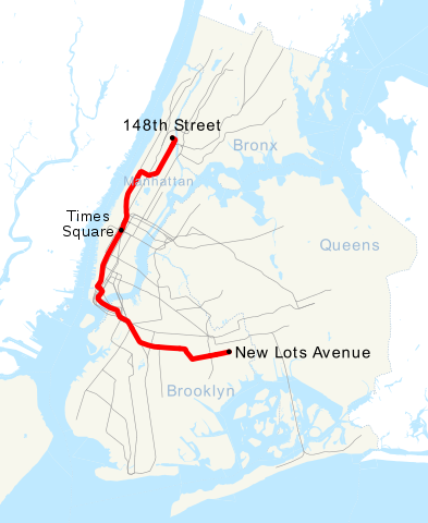
| 描述 | This is a map showing the New York City Subway's 3 service. It was created with TIGER/Line GIS data (water and boundaries) and my own data (subway lines and stations, traced on TIGER/Line road data). If you would like a copy of the subway data, email me. |
| 日期 | 2007年4月30日 (原始上傳日期) |
| 來源 | No machine-readable source provided. Own work assumed (based on copyright claims). |
| 作者 | No machine-readable author provided. NE2 assumed (based on copyright claims). |
授權條款
| 我,此作品的版權所有人,釋出此作品至公共領域。此授權條款在全世界均適用。 這可能在某些國家不合法,如果是的話: 我授予任何人有權利使用此作品於任何用途,除受法律約束外,不受任何限制。 |
檔案歷史
點選日期/時間以檢視該時間的檔案版本。
| 日期/時間 | 縮圖 | 尺寸 | 使用者 | 備註 | |
|---|---|---|---|---|---|
| 目前 | 2018年6月23日 (六) 16:28 | | 648 × 792(417 KB) | LRG5784 | Reverted to version as of 22:44, 20 March 2016 (UTC) End of weekend changes |
| 2017年6月26日 (一) 19:03 |  | 648 × 792(442 KB) | PrecipiceofDuck | Updated with Hurricane Sandy Fix&Fortify Clark St Tunnel repair work | |
| 2016年3月20日 (日) 22:44 |  | 648 × 792(417 KB) | PrecipiceofDuck | Map updated to show Times Square as late night terminal. | |
| 2016年3月18日 (五) 21:50 |  | 648 × 792(415 KB) | PrecipiceofDuck | Map updated to include 7 line extension. | |
| 2011年11月4日 (五) 21:50 |  | 648 × 792(343 KB) | Train2104 | Text to path | |
| 2007年4月30日 (一) 23:54 |  | 648 × 792(391 KB) | NE2 | == Summary == This is a map showing the New York City Subway's 3 service. It was created with TIGER/Line GIS data (water and boundaries) and my own data (subway lines and stations, traced on TIGER/Line road data). If you would like a copy of the subway da |
檔案用途
下列頁面有用到此檔案:
全域檔案使用狀況
以下其他 wiki 使用了這個檔案:
- ca.wikipedia.org 的使用狀況
- de.wikipedia.org 的使用狀況
- en.wikipedia.org 的使用狀況
- es.wikipedia.org 的使用狀況
- fi.wikipedia.org 的使用狀況
- fr.wikipedia.org 的使用狀況
- he.wikipedia.org 的使用狀況
- ja.wikipedia.org 的使用狀況
- ko.wikipedia.org 的使用狀況
- lmo.wikipedia.org 的使用狀況
- nl.wikipedia.org 的使用狀況
- no.wikipedia.org 的使用狀況
- pl.wikipedia.org 的使用狀況
- pt.wikipedia.org 的使用狀況
- ru.wikipedia.org 的使用狀況
- www.wikidata.org 的使用狀況