File:Bathymetric map of Guam.jpg
預覽大小:596 × 600 像素。 其他解析度:238 × 240 像素 | 477 × 480 像素 | 763 × 768 像素 | 1,018 × 1,024 像素 | 2,058 × 2,071 像素。
原始檔案 (2,058 × 2,071 像素,檔案大小:367 KB,MIME 類型:image/jpeg)
摘要
| 描述 |
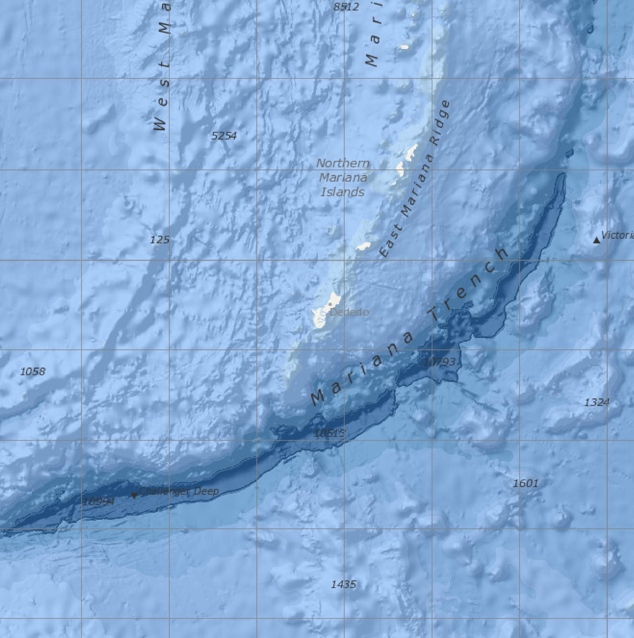
English: Bathymetric map screenshot of the NOAA Marine Geology Data visualizer, showing the immediate vicinity of Guam. Features named include the Mariana Trench, East Mariana Ridge, and Challenger Deep. Features indicated but not named are Sirena Deep, directly south of Guam, and Nero Deep.
From Version 2.72. of Marine Geology Data, last updated 10/2/2020. |
| 日期 | |
| 來源 | https://maps.ngdc.noaa.gov/viewers/marine_geology/, selection and crop by uploader |
| 作者 | National Centers for Environmental Information, NOAA |
| 其他版本 |
授權條款
此作品在美國屬於公有領域,因為其是由美國政府的官員或僱員,基於其個人公務目的製作的作品,參考美國法典第17篇第1章第105條。
注意︰本模板僅適用於美國聯邦政府的原創作品,不適用於任何美國州、屬地、聯邦個體、縣、市或任何次級政府的作品。本模板也不適用於1978年以後由美國郵政署出版的郵票圖案(參看美國版權局實踐綱領第313.6(C)(1)條)。也不適用於部分美國硬幣;參看美國鑄幣局使用條款。 |
 | |
| 此作品無已知的著作權限制,亦不受所有相關和鄰接的權利限制。 | ||
檔案歷史
點選日期/時間以檢視該時間的檔案版本。
| 日期/時間 | 縮圖 | 尺寸 | 用戶 | 備註 | |
|---|---|---|---|---|---|
| 目前 | 2021年3月13日 (六) 23:04 | | 2,058 × 2,071(367 KB) | Featous | File:Bathymetric map of Guam.pdf cropped using CropTool with lossless mode. Making JPG. |
檔案用途
下列頁面有用到此檔案:
全域檔案使用狀況
以下其他 wiki 使用了這個檔案:
- en.wikipedia.org 的使用狀況
- nl.wikipedia.org 的使用狀況