File:Ganymede terrain.jpg

原始檔案 (1,764 × 809 像素,檔案大小:729 KB,MIME 類型:image/jpeg)
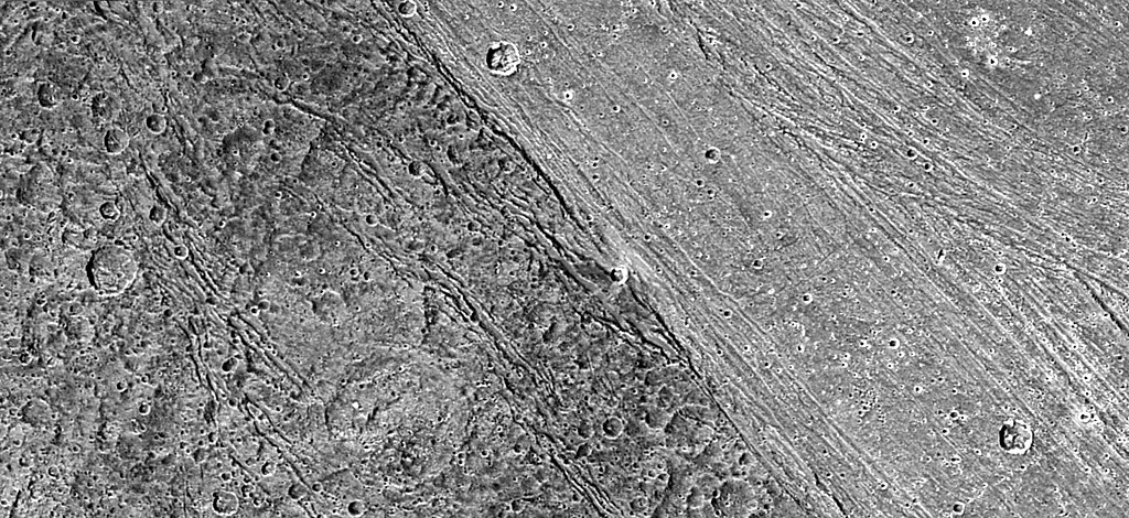
Terrain on Ganymede.
| 本作品由NASA創作,屬於公有領域。根據NASA的版權政策:“NASA的創作除非另有聲明否則不受版權保護。”(參見:Template:PD-USGov/zh,NASA版權政策或JPL圖像使用政策) | ||
 |
警告:
|
| 描述 |
English: Boundary between dark and light terrain on Ganymede. The photo is PIA02577 at the JPL Planetary Photojournal. It was taken by the Galileo spacecraft.
Original NASA caption: The ancient, dark terrain of Nicholson Regio (left) shows many large impact craters, and zones of fractures oriented generally parallel to the boundary between the dark and bright regions of Jupiter's moon Ganymede. In contrast, the bright terrain of Harpagia Sulcus (right) is less cratered and relatively smooth. The nature of the boundary between ancient, dark terrain and younger, bright terrain, the two principal terrain types on Ganymede, was explored by NASA's Galileo spacecraft on May 20, 2000. Subtle parallel ridges and grooves show that Harpagia Sulcus's land has been smoothed out over the years by tectonic processes. North is to the top of the picture. The Sun illuminates the surface from the left. The image, centered at ?14 degrees latitude and 319 degrees longitude, covers an area approximately 213 by 97 kilometers (132 by 60 miles.) The resolution is 121 meters (about 250 feet) per picture element. The images were taken on May 20, 2000, at a range of 11,800 kilometers (about 7,300 miles). |
| 來源 | http://photojournal.jpl.nasa.gov/catalog/PIA02577 |
| 作者 | NASA/JPL/DLR |
檔案歷史
點選日期/時間以檢視該時間的檔案版本。
| 日期/時間 | 縮圖 | 尺寸 | 用戶 | 備註 | |
|---|---|---|---|---|---|
| 目前 | 2005年6月4日 (六) 20:58 | | 1,764 × 809(729 KB) | Dbenbenn | 1764x809 version, converted from TIF with quality 95% |
| 2005年4月1日 (五) 01:35 |  | 1,476 × 677(255 KB) | Smartech~commonswiki | {{PD-USGov-NASA}} A picture of terrain on Ganymede, the satellite of Jupiter. From the english article about Ganymede. |
檔案用途
下列頁面有用到此檔案:
全域檔案使用狀況
以下其他 wiki 使用了這個檔案:
- af.wikipedia.org 的使用狀況
- als.wikipedia.org 的使用狀況
- ast.wikipedia.org 的使用狀況
- ba.wikipedia.org 的使用狀況
- bg.wikipedia.org 的使用狀況
- br.wikipedia.org 的使用狀況
- ca.wikipedia.org 的使用狀況
- cs.wikipedia.org 的使用狀況
- en.wikipedia.org 的使用狀況
- en.wikiversity.org 的使用狀況
- eo.wikipedia.org 的使用狀況
- eu.wikipedia.org 的使用狀況
- fr.wikipedia.org 的使用狀況
- hy.wikipedia.org 的使用狀況
- id.wikipedia.org 的使用狀況
- ja.wikipedia.org 的使用狀況
- ko.wikipedia.org 的使用狀況
- nn.wikipedia.org 的使用狀況
- no.wikipedia.org 的使用狀況
- oc.wikipedia.org 的使用狀況
- ro.wikipedia.org 的使用狀況
- ru.wikipedia.org 的使用狀況
- sk.wikipedia.org 的使用狀況
- sr.wikipedia.org 的使用狀況
- sv.wikipedia.org 的使用狀況
- ta.wikipedia.org 的使用狀況
- uk.wikipedia.org 的使用狀況
- vi.wikipedia.org 的使用狀況