File:Generalgouvernement fur die besetzten polnischen gebiete.png

預覽大小:556 × 599 像素。 其他解析度:223 × 240 像素 | 445 × 480 像素 | 713 × 768 像素 | 950 × 1,024 像素 | 1,610 × 1,735 像素。
原始檔案 (1,610 × 1,735 像素,檔案大小:523 KB,MIME 類型:image/png)
摘要
| 描述 |
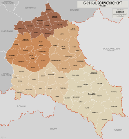
English: Administrative map of the Generalgouvernement für die besetzten polnischen Gebiete. |
| 日期 | |
| 來源 | 自己的作品 |
| 作者 | XrysD |
| 其他版本 | File:General Government for the occupied Polish territories.png |
授權條款
我,本作品的著作權持有者,決定用以下授權條款發佈本作品:
此檔案採用共享創意 姓名標示-相同方式分享 3.0 未在地化版本授權條款。
- 您可以自由:
- 分享 – 複製、發佈和傳播本作品
- 重新修改 – 創作演繹作品
- 惟需遵照下列條件:
- 姓名標示 – 您必須指名出正確的製作者,和提供授權條款的連結,以及表示是否有對內容上做出變更。您可以用任何合理的方式來行動,但不得以任何方式表明授權條款是對您許可或是由您所使用。
- 相同方式分享 – 如果您利用本素材進行再混合、轉換或創作,您必須基於如同原先的相同或兼容的條款,來分布您的貢獻成品。

|
已授權您依據自由軟體基金會發行的無固定段落、封面文字和封底文字GNU自由文件授權條款1.2版或任意後續版本,對本檔進行複製、傳播和/或修改。該協議的副本列在GNU自由文件授權條款中。 |
您可以選擇您需要的授權條款。
檔案歷史
點選日期/時間以檢視該時間的檔案版本。
| 日期/時間 | 縮圖 | 尺寸 | 用戶 | 備註 | |
|---|---|---|---|---|---|
| 目前 | 2021年10月17日 (日) 10:11 | | 1,610 × 1,735(523 KB) | XrysD | Incorporated typos KRUBIESZOW->HRUBIESZOW and CZORTZOW->CZORTKOW |
| 2021年10月11日 (一) 18:12 |  | 1,610 × 1,735(575 KB) | Kamilhrub | Czortzow → Czortkow | |
| 2021年10月6日 (三) 10:30 |  | 1,610 × 1,735(575 KB) | Kamilhrub | Corrected name Hrubieszow and southern borders of Bilgoraj, Hrubieszow and Zamosc districts, which didn't change after 1941 (source: Amtliches Gemeinde- und Dorfverzeichnis für das Generalgouvernement auf Grund der Summarischen Bevölkerungsbestandsaufnahme am 1. März 1943) | |
| 2015年5月8日 (五) 09:41 |  | 1,610 × 1,735(438 KB) | RokerHRO | optipng -o7 -i0 → 21.79% decrease | |
| 2015年4月19日 (日) 10:36 |  | 1,610 × 1,735(560 KB) | XrysD | Komplett neue Karte. Grundkarte: Karte des Deutschen Reiches 1:100k, Karte von Mitteleuropa 1:300k, Mapa Administracyjna Rzeczypospolitej Polska 1:300k (Quelle mapyWIG). | |
| 2012年5月27日 (日) 16:18 |  | 2,299 × 2,280(398 KB) | XrysD | Fixed typos | |
| 2012年5月26日 (六) 19:51 |  | 2,299 × 2,280(396 KB) | XrysD | Changed version to all German Language. Changed all colours to use Bartholomew set. English language version can now be found under File:General Government for the occupied Polish territories.png | |
| 2012年5月26日 (六) 19:45 |  | 2,299 × 2,280(396 KB) | XrysD | Changed version to all German Language. Changed all colours to use Bartholomew set. English language version can now be found under File:General Government for the occupied Polish territories.png | |
| 2009年1月23日 (五) 20:38 |  | 2,299 × 2,280(391 KB) | XrysD | {{Information |Description= |Source= |Date= |Author= |Permission= |other_versions= }} | |
| 2008年11月29日 (六) 19:36 |  | 2,299 × 2,279(367 KB) | XrysD | {{Information |Description={{en|1=Administrative map of the Generalgouvernement für die besetzten polnischen Gebiete.}} |Source=Own work by uploader |Author=XrysD |Date=29/11/2008 |Permission= |other_versions= }} <!--{{ImageUpload|full}}- |
檔案用途
下列頁面有用到此檔案:
全域檔案使用狀況
以下其他 wiki 使用了這個檔案:
- ar.wikipedia.org 的使用狀況
- ast.wikipedia.org 的使用狀況
- ba.wikipedia.org 的使用狀況
- be-tarask.wikipedia.org 的使用狀況
- ca.wikipedia.org 的使用狀況
- cs.wikipedia.org 的使用狀況
- de.wikipedia.org 的使用狀況
- el.wikipedia.org 的使用狀況
- es.wikipedia.org 的使用狀況
- fi.wikipedia.org 的使用狀況
- fr.wikipedia.org 的使用狀況
- fr.wiktionary.org 的使用狀況
- gl.wikipedia.org 的使用狀況
- hu.wikipedia.org 的使用狀況
- it.wikipedia.org 的使用狀況
- sh.wikipedia.org 的使用狀況
- simple.wikipedia.org 的使用狀況
- sr.wikipedia.org 的使用狀況
- sv.wikipedia.org 的使用狀況
- uk.wikipedia.org 的使用狀況
- www.wikidata.org 的使用狀況