File:Naktong Defense.jpg
預覽大小:372 × 599 像素。 其他解析度:149 × 240 像素 | 587 × 945 像素。
原始檔案 (587 × 945 像素,檔案大小:427 KB,MIME 類型:image/jpeg)
摘要
| 描述 |
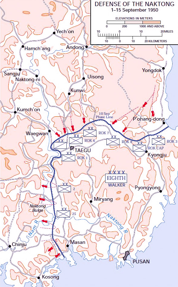
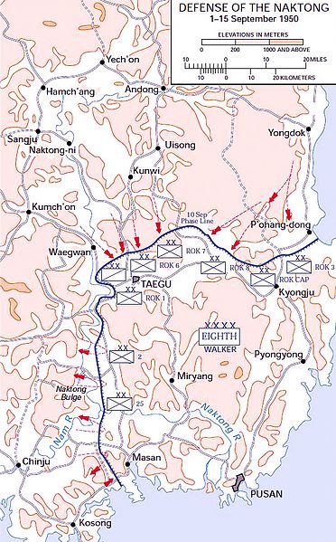
English: Map of the Naktong Defense lines, September 1950. This map was created by the United States Army Center of Military History (USACMH) and used in the brochure "The Korean War: The Outbreak" located at [1]. |
| 日期 | 2006年十二月27日 (原始上傳日期) |
| 來源 | Transferred from en.wikipedia to Commons. |
| 作者 | 原上傳者為英文維基百科的Wbfergus |
| 其他版本 |
|
.jpg)
.jpg)
.jpg)
.jpg)
.jpg)
原始上傳日誌
The original description page was here. All following user names refer to en.wikipedia.
- 2006-12-27 13:30 Wbfergus 350×572×8 (48792 bytes) Map of the Naktong Defense lines, September 1950. This map was created by the Center for Military History and used in the brochure "The Korean War: The Outbreak" located at [2].
授權條款
|
|
 |
檔案歷史
點選日期/時間以檢視該時間的檔案版本。
| 日期/時間 | 縮圖 | 尺寸 | 用戶 | 備註 | |
|---|---|---|---|---|---|
| 目前 | 2016年11月25日 (五) 18:40 | | 587 × 945(427 KB) | Julien1978 | saturation |
| 2016年11月25日 (五) 18:36 |  | 587 × 945(375 KB) | Julien1978 | résolution | |
| 2010年11月16日 (二) 03:04 |  | 350 × 572(48 KB) | Pollyanna1919 | == {{int:filedesc}} == {{Information |Description={{en|Map of the Naktong Defense lines, September 1950.<br> This map was created by the Center for Military History and used in the brochure "The Korean War: The Outbreak" located at [http://www.army.mil/cm |
檔案用途
全域檔案使用狀況
以下其他 wiki 使用了這個檔案:
- cs.wikipedia.org 的使用狀況
- en.wikipedia.org 的使用狀況
- fa.wikipedia.org 的使用狀況
- fr.wikipedia.org 的使用狀況
- ko.wikipedia.org 的使用狀況
- ru.wikipedia.org 的使用狀況
- uk.wikipedia.org 的使用狀況
- vi.wikipedia.org 的使用狀況
- www.wikidata.org 的使用狀況