File:Partition of India 1947 en.svg

此 SVG 檔案的 PNG 預覽的大小:609 × 599 像素。 其他解析度:244 × 240 像素 | 488 × 480 像素 | 780 × 768 像素 | 1,041 × 1,024 像素 | 2,081 × 2,048 像素 | 1,189 × 1,170 像素。
原始檔案 (SVG 檔案,表面大小:1,189 × 1,170 像素,檔案大小:724 KB)
摘要
| 描述 |
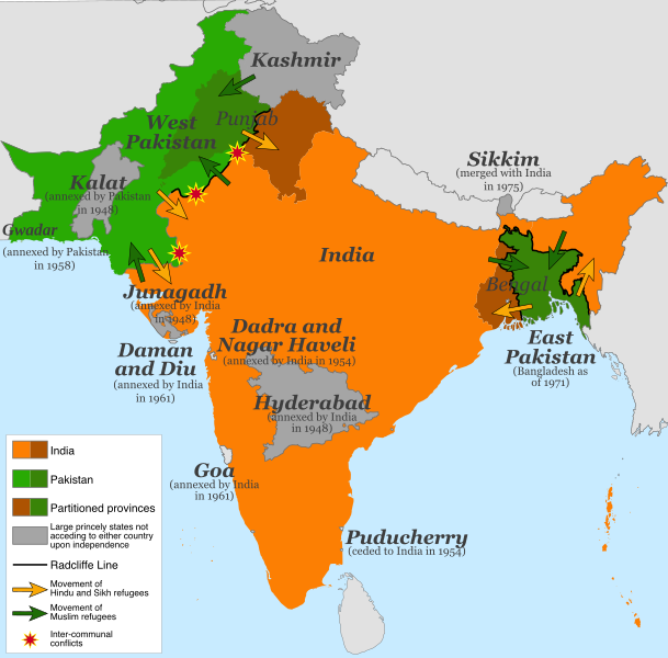
English: Map of the partition of India (1947). Note: Small princely states not acceding to either country upon independence are shown as integral parts of India and Pakistan. |
| 日期 | |
| 來源 |
本檔案衍生自: |
| 作者 | 自己的作品 |
| 其他版本 |
[]
|


.svg)


.svg)
授權條款
此檔案採用共享創意 姓名標示-相同方式分享 4.0 國際授權條款。
- 您可以自由:
- 分享 – 複製、發佈和傳播本作品
- 重新修改 – 創作演繹作品
- 惟需遵照下列條件:
- 姓名標示 – 您必須指名出正確的製作者,和提供授權條款的連結,以及表示是否有對內容上做出變更。您可以用任何合理的方式來行動,但不得以任何方式表明授權條款是對您許可或是由您所使用。
- 相同方式分享 – 如果您利用本素材進行再混合、轉換或創作,您必須基於如同原先的相同或兼容的條款,來分布您的貢獻成品。
檔案歷史
點選日期/時間以檢視該時間的檔案版本。
| 日期/時間 | 縮圖 | 尺寸 | 用戶 | 備註 | |
|---|---|---|---|---|---|
| 目前 | 2017年7月5日 (三) 13:15 | | 1,189 × 1,170(724 KB) | RaviC | some rendering adjustments |
| 2017年7月5日 (三) 13:14 |  | 1,189 × 1,170(717 KB) | RaviC | + Gwadar | |
| 2017年4月30日 (日) 02:57 |  | 1,189 × 1,170(661 KB) | फ़िलप्रो | Kalat and Dadra and Nagar Haveli border width. | |
| 2017年4月30日 (日) 02:46 |  | 1,189 × 1,170(648 KB) | फ़िलप्रो | Fixed Junagadh, location of Diu (Daman and Diu), and added Dadra and Nagar Haveli. | |
| 2017年4月30日 (日) 01:31 |  | 1,189 × 1,170(643 KB) | फ़िलप्रो | Added labels for other annexed princely states. Fixed shape of Bengal and Punjab provinces as per their sizes in 1947. | |
| 2017年2月11日 (六) 12:17 |  | 1,189 × 1,170(433 KB) | Superbenjamin | User created page with UploadWizard |
檔案用途
全域檔案使用狀況
以下其他 wiki 使用了這個檔案:
- af.wikipedia.org 的使用狀況
- als.wikipedia.org 的使用狀況
- ast.wikipedia.org 的使用狀況
- az.wikipedia.org 的使用狀況
- bg.wikipedia.org 的使用狀況
- ca.wikipedia.org 的使用狀況
- da.wikipedia.org 的使用狀況
- de.wikipedia.org 的使用狀況
- de.wikiversity.org 的使用狀況
- en.wikipedia.org 的使用狀況
- es.wikipedia.org 的使用狀況
- eu.wikipedia.org 的使用狀況
- fi.wikipedia.org 的使用狀況
- ga.wikipedia.org 的使用狀況
- he.wikipedia.org 的使用狀況
- hy.wikipedia.org 的使用狀況
- id.wikipedia.org 的使用狀況
- is.wikipedia.org 的使用狀況
- ja.wikipedia.org 的使用狀況
- ka.wikipedia.org 的使用狀況
- ko.wikipedia.org 的使用狀況
- lv.wikipedia.org 的使用狀況
- ml.wikipedia.org 的使用狀況
- mr.wikipedia.org 的使用狀況
- nl.wikipedia.org 的使用狀況
- nn.wikipedia.org 的使用狀況
- nn.wikiquote.org 的使用狀況
- no.wikipedia.org 的使用狀況
- pnb.wikipedia.org 的使用狀況
檢視此檔案的更多全域使用狀況。