File:2013 Boston Marathon bombings map.png

原始檔案(887 × 819 像素,檔案大小:680 KB,MIME 類型:image/png


本圖片是以PNG、GIF或JPEG格式上傳。然而,其中包含的資料或訊息,應該重新建立成可縮放向量圖形SVG)檔案,以更有效率或更準確的方式儲存。如有可能,請上傳本圖片的SVG格式版本。在上傳之後,請修改維基各姊妹計畫中所有使用舊版圖片的條目(列在圖像連結章節中),替換為新版圖片,並在舊圖片的描述頁中加入{{Vector version available|新圖片名稱.svg}}模板,同時移除本模板。

摘要

描寫
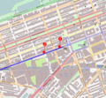
English: 2013 Boston Marathon bombings map.

The first bomb exploded at 671-673 Boylston Street, Boston, MA (42.349886, -71.078864): "MacDonald said one explosion had happened in front of the Marathon Sports store at 671-673 Boylston and the windows were blown out at a LensCrafters store, where 'the sidewalk is loaded with blood.'" 'Explosions rock Boston Marathon finish line; dozens injured', The Boston Globe. April 15, 2013 See also[1]

The marathon route is shown in dark blue, the finish line in yellow, and the area for runners only is in lighter blue. The family meeting area is in lighter yellow. See Boston Marathon Course Maps.
本Boston 的地圖以OpenStreetMap計畫資料建立,由社群收集。 此地圖可能不完整,也可能包含錯誤。別只用它當導航。
日期
來源 您可以在Boston的OpenStreetMap wiki頁面找到有關頁面
創作作者
OpenStreetMap 貢獻者
授權許可
(重用此檔案)

OpenStreetMap的資料依據開放資料庫授權條款細節)提供。圖磚採用創用CC姓名標示-相同方式分享 2.0(CC-BY-SA 2.0)條款授權。

This work contains information from OpenStreetMap, which is made available under the Open Database License (ODbL).

The ODbL does not require any particular license for maps produced from ODbL data. Prior to 1 August 2020, map tiles produced by the OpenStreetMap Foundation were licensed under the CC-BY-SA-2.0 license. Maps produced by other people may be subject to other licences.

w:zh:共享創意
姓名標示 相同方式分享
您可以自由:
  • 分享 – 複製、發佈和傳播本作品
  • 重新修改 – 創作演繹作品
惟需遵照下列條件:
  • 姓名標示 – 您必須指名出正確的製作者,和提供授權條款的連結,以及表示是否有對內容上做出變更。您可以用任何合理的方式來行動,但不得以任何方式表明授權條款是對您許可或是由您所使用。
  • 相同方式分享 – 如果您利用本素材進行再混合、轉換或創作,您必須基於如同原先的相同或兼容的條款,來分布您的貢獻成品。
地理參考 地理參考Wikimaps Warper中的地圖 如果不合適,請設定「warp_status = skip」為隱藏。


授權條款

This work contains information from OpenStreetMap, which is made available under the Open Database License (ODbL).

The ODbL does not require any particular license for maps produced from ODbL data. Prior to 1 August 2020, map tiles produced by the OpenStreetMap Foundation were licensed under the CC-BY-SA-2.0 license. Maps produced by other people may be subject to other licences.

w:zh:共享創意
姓名標示 相同方式分享
您可以自由:
  • 分享 – 複製、發佈和傳播本作品
  • 重新修改 – 創作演繹作品
惟需遵照下列條件:
  • 姓名標示 – 您必須指名出正確的製作者,和提供授權條款的連結,以及表示是否有對內容上做出變更。您可以用任何合理的方式來行動,但不得以任何方式表明授權條款是對您許可或是由您所使用。
  • 相同方式分享 – 如果您利用本素材進行再混合、轉換或創作,您必須基於如同原先的相同或兼容的條款,來分布您的貢獻成品。

說明

添加單行說明來描述出檔案所代表的內容

在此檔案描寫的項目

描繪內容

波士頓馬拉松爆炸案 中文 (已轉換拼寫)

波士頓馬拉松爆炸案 中文 (已轉換拼寫)

著作權狀態 繁體中文 (已轉換拼寫)

有著作權 繁體中文 (已轉換拼寫)

多媒體型式 繁體中文 (已轉換拼寫)

image/png

校驗和 繁體中文 (已轉換拼寫)

f09e12d0a04535bb38f8da7b06ba68c31f0dc97a

斷定方法:​SHA-1 中文 (已轉換拼寫)

資料大小 Chinese (Hong Kong) (已轉換拼寫)

696,674 位元組

819 像素

887 像素

檔案歷史

點選日期/時間以檢視該時間的檔案版本。

日期/時間縮⁠圖尺寸用戶備⁠註
目前2013年4月17日 (三) 18:06於 2013年4月17日 (三) 18:06 版本的縮圖887 × 819(680 KB)Aptevaroute correction
2013年4月17日 (三) 03:13於 2013年4月17日 (三) 03:13 版本的縮圖887 × 819(705 KB)Ke4rohAdd route information - marathon course dark blue, finish line yellow, runner only area light blue, family meeting area yellow
2013年4月16日 (二) 00:10於 2013年4月16日 (二) 00:10 版本的縮圖887 × 819(712 KB)Odderthe first blast was too far left; pictures suggest the blasts took place on the sidewalk, and not in the middle of the street
2013年4月15日 (一) 23:50於 2013年4月15日 (一) 23:50 版本的縮圖887 × 819(711 KB)Oddernumbers, circle => 9-pointed star, reduced size of the blast indicators per talk page comment
2013年4月15日 (一) 23:45於 2013年4月15日 (一) 23:45 版本的縮圖887 × 819(556 KB)Anna Frodesiakadjust location of second blast
2013年4月15日 (一) 23:05於 2013年4月15日 (一) 23:05 版本的縮圖887 × 819(555 KB)Anna Frodesiakversion showing site of second blast
2013年4月15日 (一) 22:51於 2013年4月15日 (一) 22:51 版本的縮圖887 × 819(556 KB)Anna Frodesiakversion showing first blast site
2013年4月15日 (一) 22:46於 2013年4月15日 (一) 22:46 版本的縮圖887 × 819(515 KB)Anna FrodesiakUser created page with UploadWizard

下列頁面有用到此檔案:

全域檔案使用狀況

以下其他 wiki 使用了這個檔案:

詮釋資料