File:Trinity crater (annotated) 2.jpg
預覽大小:700 × 599 像素。 其他解析度:280 × 240 像素 | 561 × 480 像素。
原始檔案 (800 × 685 像素,檔案大小:193 KB,MIME 類型:image/jpeg)
_2.jpg?uselang=zh-mo)
_2.jpg?uselang=zh-mo)
_2.jpg?action=history&uselang=zh-mo)
_2.jpg)
| 描述 |
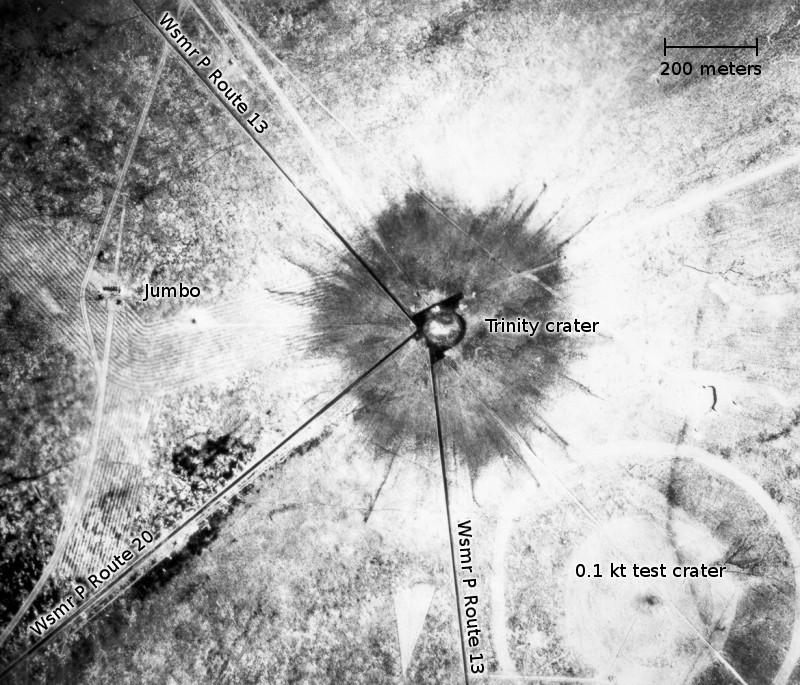
English: White Sands, New Mexico. Aerial view of the aftermath of the Trinity test, 28 hours after the explosion. The smaller crater to the southeast is from the earlier detonation of 100 tons of TNT on May 7, 1945. To the left of the crater can be seen the "Jumbo" container, unharmed, and its collapsed tower (a vertical line). |
| 日期 | (UTC) |
| 來源 | |
| 作者 |
|
| 這是一張修飾過的圖片,即本圖片是用軟體修改過後的版本,修改的方式或內容有:Road names, scale and annotations added。原版圖片來源:Trinity crater.jpg。修改者:Bomazi。
|
| 我,此作品的版權所有人,釋出此作品至公共領域。此授權條款在全世界均適用。 這可能在某些國家不合法,如果是的話: 我授予任何人有權利使用此作品於任何用途,除受法律約束外,不受任何限制。 |
檔案歷史
點選日期/時間以檢視該時間的檔案版本。
| 日期/時間 | 縮圖 | 尺寸 | 用戶 | 備註 | |
|---|---|---|---|---|---|
| 目前 | 2011年1月27日 (四) 04:37 | | 800 × 685(193 KB) | Bomazi | {{Information |Description={{en|White Sands, New Mexico. Aerial view of the aftermath of the Trinity test, 28 hours after the explosion. The smaller crater to the southeast is from the earlier detonation of 100 tons of TNT on May 7, 1945. To the left of t |
檔案用途
下列頁面有用到此檔案:
全域檔案使用狀況
以下其他 wiki 使用了這個檔案:
- de.wikipedia.org 的使用狀況
- en.wikipedia.org 的使用狀況
- fa.wikipedia.org 的使用狀況
- fr.wikipedia.org 的使用狀況
- he.wikipedia.org 的使用狀況
- hu.wikipedia.org 的使用狀況
- uz.wikipedia.org 的使用狀況
_2.jpg)