File:Myanmar civil war.svg

原始文件 (SVG文件,尺寸为1,228 × 2,003像素,文件大小:1.32 MB)

|
This file may be updated to reflect new information. If you wish to use a specific version of the file without new updates being mirrored, please upload the required version as a separate file. |
摘要
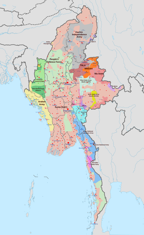
| 描述 |
English: A map of the Myanmar civil war (2021–present)
|
| 日期 | |
| 来源 | 自己的作品 derivate of Myanmar adm location map.svg 由 NordNordWest. Citing @ThomasVLinge |
| 作者 | Ecrusized |
| 其他版本 |
|

This file is translated using SVG <switch> elements. All translations are stored in the same file! Learn more.
For most Wikipedia projects, you can embed the file normally (without a To translate the text into your language, you can use the SVG Translate tool. Alternatively, you can download the file to your computer, add your translations using whatever software you're familiar with, and re-upload it with the same name. You will find help in Graphics Lab if you're not sure how to do this. |
许可协议
| 本作品采用知识共享CC0 1.0 通用公有领域贡献许可协议授权。 | |
| 采用本宣告发表本作品的人,已在法律允许的范围内,通过在全世界放弃其对本作品拥有的著作权法规定的所有权利(包括所有相关权利),将本作品贡献至公有领域。您可以复制、修改、传播和表演本作品,将其用于商业目的,无需要求授权。
|
文件历史
点击某个日期/时间查看对应时刻的文件。
| 日期/时间 | 缩略图 | 大小 | 用户 | 备注 | |
|---|---|---|---|---|---|
| 当前 | 2024年5月29日 (三) 03:52 | | 1,228 × 2,003(1.32 MB) | EmeraldRange | Quick fix of Mong Pan/ Mong Pawn |
| 2024年5月29日 (三) 01:38 |  | 1,228 × 2,003(1.32 MB) | EmeraldRange | Updated smaller fixes from Talk on en:Myanmar civil war; added BGFs that act more independently/as relevant and add UNLFWESEA | |
| 2024年5月26日 (日) 14:29 |  | 1,228 × 2,003(1.3 MB) | MrBLOCKiron | Continuation and corrections of recent edit, check discussion | |
| 2024年5月24日 (五) 19:44 |  | 1,228 × 2,003(1.31 MB) | MrBLOCKiron | New updates for May, check discussion for notes | |
| 2024年5月22日 (三) 18:18 |  | 1,228 × 2,003(1.31 MB) | UnJapóLliure | Updated to 22 May 2024 | |
| 2024年4月30日 (二) 10:32 |  | 1,228 × 2,003(1.3 MB) | MrBLOCKiron | Continuation of yesterdays edit, check april 29 discussion. | |
| 2024年4月29日 (一) 16:45 |  | 1,228 × 2,003(1.3 MB) | MrBLOCKiron | Update, check talk page for notes and sources | |
| 2024年4月17日 (三) 18:46 |  | 1,228 × 2,003(1.29 MB) | EmeraldRange | Updating Myawaddy area to reflect territory taken - Shwekoko to the north and Thinganyinaung to the west as per Talk on en:Myanmar civil war (2021-present) | |
| 2024年4月12日 (五) 03:01 |  | 1,228 × 2,003(1.3 MB) | PequodOnStationAtLZ | updated to reflect rebel capture of myawaddy | |
| 2024年4月4日 (四) 20:52 |  | 1,228 × 2,003(1.3 MB) | EmeraldRange | Updated based on Timelines , sources and new map from van Linge; see File Talk/Discusion for sources |
文件用途
以下3个页面使用本文件:
全域文件用途
以下其他wiki使用此文件:
- ar.wikipedia.org上的用途
- de.wikipedia.org上的用途
- en.wikipedia.org上的用途
- es.wikipedia.org上的用途
- et.wikipedia.org上的用途
- fa.wikipedia.org上的用途
- fr.wikipedia.org上的用途
- hu.wikipedia.org上的用途
- it.wikipedia.org上的用途
- ja.wikipedia.org上的用途
- ko.wikipedia.org上的用途
- ms.wikipedia.org上的用途
- my.wikipedia.org上的用途
- pt.wikipedia.org上的用途
- ru.wikipedia.org上的用途
- th.wikipedia.org上的用途
- uk.wikipedia.org上的用途