File:Myanmar civil war.svg

原始檔案 (SVG 檔案,表面大小:1,228 × 2,003 像素,檔案大小:1.3 MB)

|
This file may be updated to reflect new information. If you wish to use a specific version of the file without new updates being mirrored, please upload the required version as a separate file. |
摘要
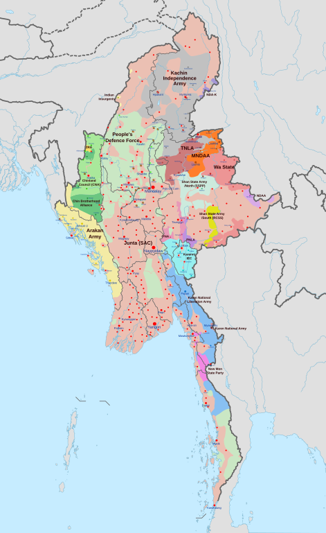
| 描述 |
English: A map of the Myanmar civil war (2021–present)
|
| 日期 | |
| 來源 | 自己的作品 derivate of Myanmar adm location map.svg 由 NordNordWest. Citing @ThomasVLinge |
| 作者 | Ecrusized |
| 其他版本 |
|

This file is translated using SVG <switch> elements. All translations are stored in the same file! Learn more.
For most Wikipedia projects, you can embed the file normally (without a To translate the text into your language, you can use the SVG Translate tool. Alternatively, you can download the file to your computer, add your translations using whatever software you're familiar with, and re-upload it with the same name. You will find help in Graphics Lab if you're not sure how to do this. |
授權條款
| 此檔案在創用CC CC0 1.0 通用公有領域貢獻宣告之下分發。 | |
| 在此宣告之下分發本作品者,已依據各國著作權法,在全世界放棄其對本作品所擁有的著作權及所有相關相似的法律權利,從而將本作品貢獻至公有領域。您可以複製、修改、分發和演示該作品,用於任何商業用途,所有這些都不需要請求授權。
|
檔案歷史
點選日期/時間以檢視該時間的檔案版本。
| 日期/時間 | 縮圖 | 尺寸 | 使用者 | 備註 | |
|---|---|---|---|---|---|
| 目前 | 2024年5月26日 (日) 14:29 | | 1,228 × 2,003(1.3 MB) | MrBLOCKiron | Continuation and corrections of recent edit, check discussion |
| 2024年5月24日 (五) 19:44 |  | 1,228 × 2,003(1.31 MB) | MrBLOCKiron | New updates for May, check discussion for notes | |
| 2024年5月22日 (三) 18:18 |  | 1,228 × 2,003(1.31 MB) | UnJapóLliure | Updated to 22 May 2024 | |
| 2024年4月30日 (二) 10:32 |  | 1,228 × 2,003(1.3 MB) | MrBLOCKiron | Continuation of yesterdays edit, check april 29 discussion. | |
| 2024年4月29日 (一) 16:45 |  | 1,228 × 2,003(1.3 MB) | MrBLOCKiron | Update, check talk page for notes and sources | |
| 2024年4月17日 (三) 18:46 |  | 1,228 × 2,003(1.29 MB) | EmeraldRange | Updating Myawaddy area to reflect territory taken - Shwekoko to the north and Thinganyinaung to the west as per Talk on en:Myanmar civil war (2021-present) | |
| 2024年4月12日 (五) 03:01 |  | 1,228 × 2,003(1.3 MB) | PequodOnStationAtLZ | updated to reflect rebel capture of myawaddy | |
| 2024年4月4日 (四) 20:52 |  | 1,228 × 2,003(1.3 MB) | EmeraldRange | Updated based on Timelines , sources and new map from van Linge; see File Talk/Discusion for sources | |
| 2024年3月23日 (六) 15:35 |  | 1,228 × 2,003(1.29 MB) | TheWasalpha | Capture of Rathedaung last week by AA, removed a misplaced dot in Bangladesh | |
| 2024年3月17日 (日) 16:47 |  | 1,228 × 2,003(1.29 MB) | EmeraldRange | Updated with other items to March 17, see File Talk/Discussion |
檔案用途
下列3個頁面有用到此檔案:
全域檔案使用狀況
以下其他 wiki 使用了這個檔案:
- ar.wikipedia.org 的使用狀況
- de.wikipedia.org 的使用狀況
- en.wikipedia.org 的使用狀況
- es.wikipedia.org 的使用狀況
- et.wikipedia.org 的使用狀況
- fa.wikipedia.org 的使用狀況
- fr.wikipedia.org 的使用狀況
- hu.wikipedia.org 的使用狀況
- it.wikipedia.org 的使用狀況
- ja.wikipedia.org 的使用狀況
- ko.wikipedia.org 的使用狀況
- ms.wikipedia.org 的使用狀況
- my.wikipedia.org 的使用狀況
- pt.wikipedia.org 的使用狀況
- ru.wikipedia.org 的使用狀況
- th.wikipedia.org 的使用狀況
- uk.wikipedia.org 的使用狀況