File:Neusiedler Lake satellite.png
預覽大小:510 × 600 像素。 其他解析度:204 × 240 像素 | 408 × 480 像素 | 797 × 937 像素。
原始檔案 (797 × 937 像素,檔案大小:1.39 MB,MIME 類型:image/png)
摘要
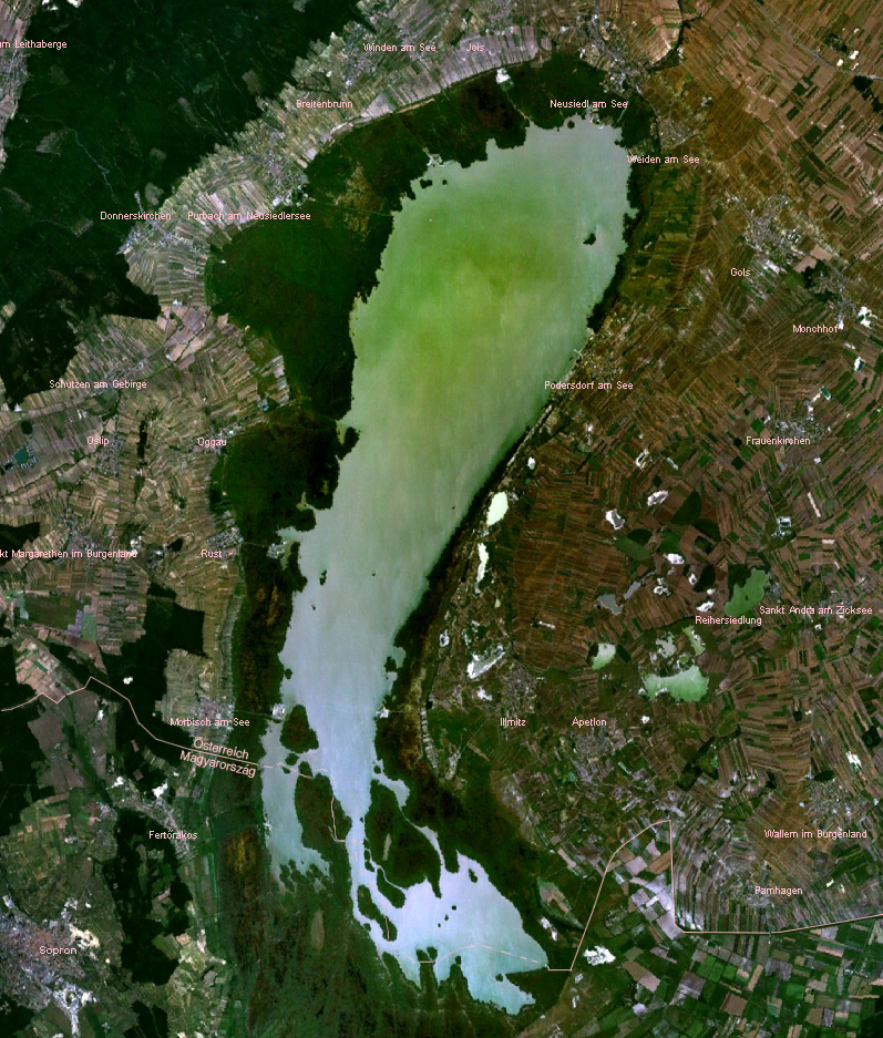
Satellite view of Neusiedler Lake in Austria / Fertő-tó in Hungary. Taken from de:Bild:Neusiedlersee NASA WorldWind.png.
授權條款
| 本圖像屬於公有領域,因其為NASA的World Wind衛星地圖瀏覽器的一張截圖,且使用了公有領域圖層,如Blue Marble、MODIS、Landsat、SRTM、USGS、GLOBE等。
|
 |
檔案歷史
點選日期/時間以檢視該時間的檔案版本。
| 日期/時間 | 縮圖 | 尺寸 | 使用者 | 備註 | |
|---|---|---|---|---|---|
| 目前 | 2020年5月6日 (三) 15:01 | | 797 × 937(1.39 MB) | Julieta39 | Change since discussion file |
| 2018年12月27日 (四) 12:08 |  | 797 × 937(1.39 MB) | Julieta39 | Austrian-Hungarian border | |
| 2007年2月7日 (三) 21:28 |  | 797 × 937(1.39 MB) | Editor at Large | Re-uploading, problem with last version | |
| 2007年2月7日 (三) 21:22 |  | 797 × 937(1.58 MB) | Editor at Large | Removed logo in corner |
檔案用途
下列頁面有用到此檔案:
全域檔案使用狀況
以下其他 wiki 使用了這個檔案:
- af.wikipedia.org 的使用狀況
- ar.wikipedia.org 的使用狀況
- az.wikipedia.org 的使用狀況
- br.wikipedia.org 的使用狀況
- cs.wikipedia.org 的使用狀況
- cv.wikipedia.org 的使用狀況
- da.wikipedia.org 的使用狀況
- de.wikipedia.org 的使用狀況
- de.wiktionary.org 的使用狀況
- en.wikipedia.org 的使用狀況
- es.wikipedia.org 的使用狀況
- fa.wikipedia.org 的使用狀況
- fi.wikipedia.org 的使用狀況
- fr.wikipedia.org 的使用狀況
- he.wikipedia.org 的使用狀況
- hr.wikipedia.org 的使用狀況
- hu.wikipedia.org 的使用狀況
- hy.wikipedia.org 的使用狀況
- id.wikipedia.org 的使用狀況
- it.wikipedia.org 的使用狀況
- ja.wikipedia.org 的使用狀況
- ka.wikipedia.org 的使用狀況
- li.wikipedia.org 的使用狀況
- mk.wikipedia.org 的使用狀況
- mt.wikipedia.org 的使用狀況
- nl.wikipedia.org 的使用狀況
- no.wikipedia.org 的使用狀況
- pl.wikipedia.org 的使用狀況
- pl.wiktionary.org 的使用狀況
檢視此檔案的更多全域使用狀況。