File:North and south pole view of Martian topography.jpg
此為最大尺寸。
North_and_south_pole_view_of_Martian_topography.jpg (590 × 99 像素,檔案大小:44 KB,MIME 類型:image/jpeg)
摘要
| 描述 |
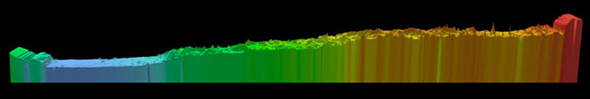
English: Above is a pole-to-pole view of Martian topography from the first MOLA global topographic model [Smith et al., Science, 1999]. The slice runs from the north pole (left) to the south pole (right) along the 0° longitude line. The figure highlights the pole-to-pole slope of 0.036°, such that the south pole has a higher elevation than the north pole by ~6 kilometers. |
| 日期 | |
| 來源 | NASA Goddard Space Center MOLA |
| 作者 | Responsible NASA Official: Gregory A. Neumann |
授權條款
| 本作品由NASA創作,屬於公有領域。根據NASA的版權政策:“NASA的創作除非另有聲明否則不受版權保護。”(參見:Template:PD-USGov/zh,NASA版權政策或JPL圖像使用政策) | ||
 |
警告:
|
檔案歷史
點選日期/時間以檢視該時間的檔案版本。
| 日期/時間 | 縮圖 | 尺寸 | 使用者 | 備註 | |
|---|---|---|---|---|---|
| 目前 | 2011年2月15日 (二) 03:04 | 590 × 99(44 KB) | Steve Quinn | {{Information |Description ={{en|1=Above is a pole-to-pole view of Martian topography from the first MOLA global topographic model [Smith et al., Science, 1999]. The slice runs from the north pole (left) to the south pole (right) along the 0° longitud |
檔案用途
下列頁面有用到此檔案:
全域檔案使用狀況
以下其他 wiki 使用了這個檔案:
- ca.wikipedia.org 的使用狀況
- en.wikipedia.org 的使用狀況
- es.wikipedia.org 的使用狀況
- it.wikipedia.org 的使用狀況