File:Roosevelt Island, Antarctica - satellite image.jpg
預覽大小:391 × 600 像素。 其他解析度:156 × 240 像素 | 313 × 480 像素 | 720 × 1,104 像素。
原始檔案 (720 × 1,104 像素,檔案大小:89 KB,MIME 類型:image/jpeg)
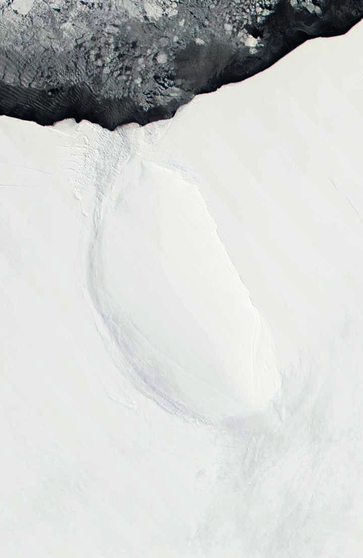
| 描述 | Roosevelt Island and coast of Ross Ice Shelf, Antarctica. Darkened and cropped from a wider view of the ice shelf, a true-color image from NASA’s Moderate Resolution Imaging Spectroradiometer (MODIS) taken on November 11 and 12, 2001. |
| 日期 | 11-12 November 2001 |
| 來源 | |
| 作者 |
|
| 這是一張修飾過的圖片,即本圖片是用軟體修改過後的版本,修改的方式或內容有:Cropped to focus on Roosevelt Island, and darkened。原版圖片來源:Ross Ice Shelf and Saunders Coast, Antarctica.A2001315.1840.250m.jpg。修改者:Avenue。
|
| 本作品由NASA創作,屬於公有領域。根據NASA的版權政策:“NASA的創作除非另有聲明否則不受版權保護。”(參見:Template:PD-USGov/zh,NASA版權政策或JPL圖像使用政策) | ||
 |
警告:
|
原始上傳日誌
This image is a derivative work of the following images:
- File:Ross_Ice_Shelf_and_Saunders_Coast,_Antarctica.A2001315.1840.250m.jpg licensed with PD-USGov-NASA
- 2010-09-23T01:55:56Z Avenue 6800x5200 (1958559 Bytes) {{Information |Description=Ross Ice Shelf and Saunders Coast, Antarctica. Original NASA description: "This pair of true-color images from NASA’s Moderate Resolution Imaging Spectroradiometer (MODIS) show the Ross Ice Shelf
Uploaded with derivativeFX
檔案歷史
點選日期/時間以檢視該時間的檔案版本。
| 日期/時間 | 縮圖 | 尺寸 | 使用者 | 備註 | |
|---|---|---|---|---|---|
| 目前 | 2010年9月23日 (四) 02:13 | | 720 × 1,104(89 KB) | Avenue | Darkened to show island better. |
| 2010年9月23日 (四) 02:12 |  | 720 × 1,104(58 KB) | Avenue | {{Information |Description=Roosevelt Island and coast of Ross Ice Shelf, Antarctica. Cropped from wider view of the ice shelf, a true-color images from NASA’s Moderate Resolution Imaging Spectroradiometer (MODIS) on November 11 and 12, 2001. |Source=*[ |
檔案用途
下列頁面有用到此檔案:
全域檔案使用狀況
以下其他 wiki 使用了這個檔案:
- ast.wikipedia.org 的使用狀況
- az.wikipedia.org 的使用狀況
- bg.wikipedia.org 的使用狀況
- ca.wikipedia.org 的使用狀況
- ceb.wikipedia.org 的使用狀況
- cs.wikipedia.org 的使用狀況
- de.wikipedia.org 的使用狀況
- el.wikipedia.org 的使用狀況
- en.wikipedia.org 的使用狀況
- es.wikipedia.org 的使用狀況
- fa.wikipedia.org 的使用狀況
- fi.wikipedia.org 的使用狀況
- fr.wikipedia.org 的使用狀況
- gl.wikipedia.org 的使用狀況
- he.wikipedia.org 的使用狀況
- it.wikipedia.org 的使用狀況
- ja.wikipedia.org 的使用狀況
- lv.wikipedia.org 的使用狀況
- nl.wikipedia.org 的使用狀況
- nn.wikipedia.org 的使用狀況
- no.wikipedia.org 的使用狀況
- pl.wikipedia.org 的使用狀況
- ru.wikipedia.org 的使用狀況
- sv.wikipedia.org 的使用狀況
- uk.wikipedia.org 的使用狀況
- www.wikidata.org 的使用狀況