File:Sts-99-patch.png

預覽大小:609 × 599 像素。 其他解析度:244 × 240 像素 | 488 × 480 像素 | 781 × 768 像素 | 1,041 × 1,024 像素 | 1,866 × 1,836 像素。
原始檔案 (1,866 × 1,836 像素,檔案大小:3 MB,MIME 類型:image/png)

|
本圖片是以PNG、GIF或JPEG格式上傳。然而,其中包含的資料或訊息,應該重新建立成可縮放向量圖形(SVG)檔案,以更有效率或更準確的方式儲存。如有可能,請上傳本圖片的SVG格式版本。在上傳之後,請修改維基各姊妹計畫中所有使用舊版圖片的條目(列在圖像連結章節中),替換為新版圖片,並在舊圖片的描述頁中加入{{Vector version available|新圖片名稱.svg}}模板,同時移除本模板。
|
摘要
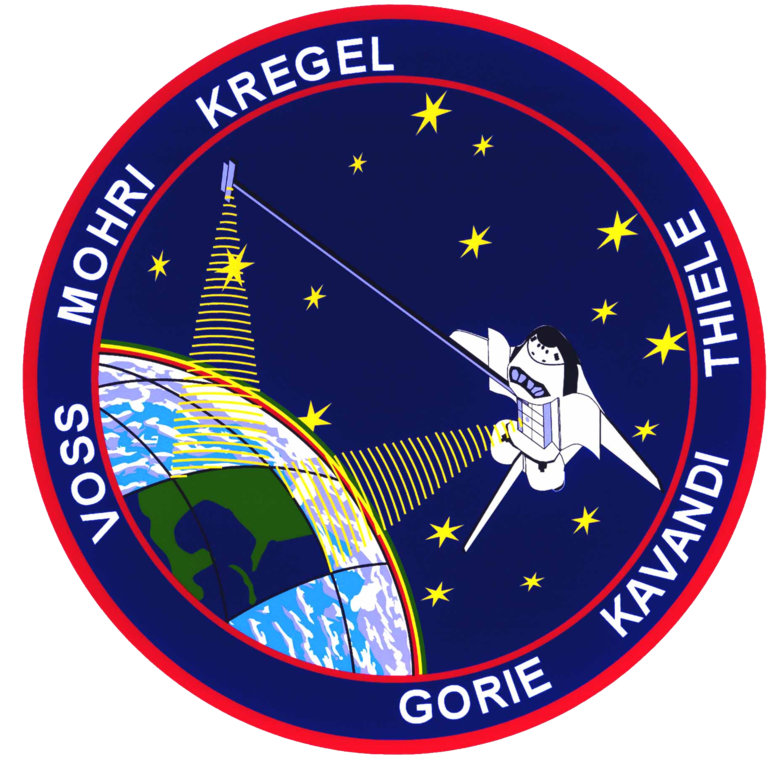
| 描述 | STS099-(S)-001 (JUNE 1999) STS-99 INSIGNIA -- The crew members designed the flight insignia for the Shuttle Radar Topography Mission (SRTM), the most ambitious Earth mapping mission to date. Two radar antennas, one located in the Shuttle bay and the other located on the end of a 60-meter deployable mast, will be used during the mission to map Earth's features. The goal is to provide a 3-dimensional topographic map of the world's surface up to the Arctic and Antarctic Circles. The clear portion of Earth illustrates the radar beams penetrating its cloudy atmosphere and the unique understanding of the home planet that is provided by space travel. The grid on Earth reflects the mapping character of the SRTM mission. The patch depicts the Space Shuttle Endeavour orbiting Earth in a star spangled universe. The rainbow along Earth's horizon resembles an orbital sunrise. The crew deems the bright colors of the rainbow as symbolic of the bright future ahead because of human beings' venturing into space. |
| 日期 | 1999年6月 |
| 來源 | NASA http://spaceflight.nasa.gov/gallery/images/shuttle/sts-99/html/sts099s001.html |
| 作者 | NASA |
本圖像或影音收錄於美國國家航空暨太空總署 (NASA)某部門,其照片編號為: STS099-(S)-001 此標籤不表示文件的著作權狀態。任何文件在附有此標籤的同時還需要一個有效的著作權標籤。請參閱許可協議說明頁面以了解更多資訊。 其他語言:
|
授權條款
| 本作品由NASA創作,屬於公有領域。根據NASA的版權政策:“NASA的創作除非另有聲明否則不受版權保護。”(參見:Template:PD-USGov/zh,NASA版權政策或JPL圖像使用政策) | ||
 |
警告:
|

|
這幅圖片所顯示的是旗幟、盾徽、印章或其他正式的徽章。在某些國家或地區使用此符號可能會受到限制,但是這些限制與版權問題無關。 |
檔案歷史
點選日期/時間以檢視該時間的檔案版本。
| 日期/時間 | 縮圖 | 尺寸 | 使用者 | 備註 | |
|---|---|---|---|---|---|
| 目前 | 2007年3月19日 (一) 17:24 | | 1,866 × 1,836(3 MB) | Fritzbox | {{ConvertToSVG|Logo}} == Summary == STS-99 Patch Category:Logos of STS missions == Licensing == {{PD-USGov-NASA}} |
檔案用途
全域檔案使用狀況
以下其他 wiki 使用了這個檔案:
- ar.wikipedia.org 的使用狀況
- ast.wikipedia.org 的使用狀況
- bg.wikipedia.org 的使用狀況
- ca.wikipedia.org 的使用狀況
- cs.wikipedia.org 的使用狀況
- da.wikipedia.org 的使用狀況
- de.wikipedia.org 的使用狀況
- el.wikipedia.org 的使用狀況
- en.wikipedia.org 的使用狀況
檢視此檔案的更多全域使用狀況。