布里恩茨红峰
(重定向自布林策羅特峰)
布里恩茨红峰(德語:Brienzer Rothorn,意即为“布里恩茨的红色山峰”)是瑞士的山峰,位於該國中北部,橫跨盧塞恩州、上瓦爾登州和伯恩州,屬於埃默河谷山的一部分,海拔高度2,350米,山體由石灰岩組成。
| Brienzer Rothorn | |
|---|---|
 从西侧看去 | |
| 最高点 | |
| 海拔 | 2,350米(7,710英尺) |
| 地形突起度 | 1,342米(4,403英尺) [1] |
| 地形孤立度 | 9.7公里(6.0英里) [2] |
| 坐标 | 46°47′13″N 8°02′49″E / 46.78694°N 8.04694°E坐标:46°47′13″N 8°02′49″E / 46.78694°N 8.04694°E |
| 命名 | |
| 譯名 | 布里恩茨的红色山峰 |
| 地理 | |
 Brienzer Rothorn 在瑞士的位置 | |
| 国家 | 瑞士 |
| 州 | 卢塞恩州, 上瓦爾登州 and 伯恩州 |
| 山脈 | 埃默河谷山 |
| 地形圖 | Swiss Federal Office of Topography swisstopo |
| 攀山 | |
| 最简路线 | 自布里恩茨乘坐登山火车,自Sörenberg乘坐缆车 |
图片 编辑
-
 Steam train (Brienzer Rothorn Bahn) on the Planalp near Mittler Stafel
 -
 Approaching the summit near Ober Stafel
 -
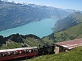 View of Lake Brienz and Interlaken in the background
 -
 The summit station over the clouds ("sea of fog") during a day in August


參考資料 编辑
- ^ Retrieved from the Swisstopo topographic maps. The key col is the Brünig Pass (1,008 m).
- ^ Retrieved from Google Earth. The nearest point of higher elevation is north of the Gärstenhoren (Schwarzhorn massif).
- map.geo.admin.ch (地图). Swiss Confederation. [2014-10-21]. (原始内容存档于2016-04-05).
- Brienzer Rothorn on Hikr (页面存档备份,存于互联网档案馆)
| 这是一篇與瑞士地理相關的小作品。你可以通过编辑或修订扩充其内容。 |