File:Île de la Possession.png
此为最大尺寸。
Île_de_la_Possession.png (372 × 244像素,文件大小:47 KB,MIME类型:image/png)
摘要
| 描述 |
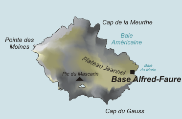
Deutsch: Karte der Île de la Possession, Crozetinseln, im südlichen Indischen Ozean
English: Map of Île de la Possession, Crozet Islands, in the Southern Indian Ocean |
| 日期 | |
| 来源 | 自己的作品, based on original from Varp |
| 作者 | modified by PoM |
| 其他版本 |

许可协议
| |
本作品已被作者[[:commons:|中文维基百科]]项目的Varp释出到公有领域。这适用于全世界。 如果这样做不合法的话: |
文件历史
点击某个日期/时间查看对应时刻的文件。
| 日期/时间 | 缩略图 | 大小 | 用户 | 备注 | |
|---|---|---|---|---|---|
| 当前 | 2021年9月9日 (四) 16:33 | | 372 × 244(47 KB) | Maisrimer | Pleateau Jeannel added |
| 2006年10月30日 (一) 15:06 |  | 372 × 244(49 KB) | PoM | Zoom de Image:Crozet_Map.png Category:Southern territories of France Category:Sub-antarctic islands |
文件用途
以下页面使用本文件:
全域文件用途
以下其他wiki使用此文件:
- af.wikipedia.org上的用途
- ar.wikipedia.org上的用途
- az.wikipedia.org上的用途
- cs.wikipedia.org上的用途
- de.wikipedia.org上的用途
- de.wikivoyage.org上的用途
- en.wikipedia.org上的用途
- eo.wikipedia.org上的用途
- es.wikipedia.org上的用途
- fa.wikipedia.org上的用途
- fr.wikipedia.org上的用途
- gl.wikipedia.org上的用途
- hr.wikipedia.org上的用途
- hu.wikipedia.org上的用途
- it.wikipedia.org上的用途
- ja.wikipedia.org上的用途
- mk.wikipedia.org上的用途
- nn.wikipedia.org上的用途
- pl.wikipedia.org上的用途
- ru.wikipedia.org上的用途
- uk.wikipedia.org上的用途
- www.wikidata.org上的用途