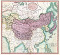
File:1806 Cary Map of Tartary or Central Asia - Geographicus - Tartary-cary-1806.jpg

原始文件(5,000 × 4,569像素,文件大小:8.57 MB,MIME类型:image/jpeg


John Cary:​A New Map of Mongolian & Independent Tartary , From the Latest Authorities.   (Wikidata search (Cirrus search) Wikidata query (SPARQL)  Create new Wikidata item based on this file)
艺术家
John Cary  (–1835)  wikidata:Q3446124 s:en:Author:John Cary
 
其他姓名
J. Cary
描述 制图师、​雕刻师、​mapseller、​printseller和平面设计师
出生/逝世日期 1755年2月23日 / 1754年 在維基數據編輯 1835年8月16日 在維基數據編輯
出生/逝世地点 Corsley 摩特雷克
工作时期 1788年 / 1793年 / 1797年 在維基數據編輯
工作地点
權威控制
artist QS:P170,Q3446124
标题
A New Map of Mongolian & Independent Tartary , From the Latest Authorities.
描述
English: An exceptionally beautiful example of John Cary’s important 1806 map of Mongolian and Independent Tartary. Covers Central Asia from the Caspian Sea to Japan, extends as far north as the Obskaia Sea and as far south as India, Burma and the Philippines. Includes the modern day nations of Uzbekistan, Kazakhstan, Turkmenistan, Kirgizstan, Tajikistan and Mongolia. One of Cary’s most interesting maps. Central Asia, despite hundreds of years of passing trade on the Silk Routes, was still, at the turn of the century a largely unknown land. Cary attempts to show some of the Silk Route passages, especially to the north of the Gobi, but ultimately admits, “The Geography of these parts is extremely obscure.” All in all, one of the most interesting and few maps of Central Asia to appear in first years of the 19th century. Prepared in 1806 by John Cary for issue in his magnificent 1808 New Universal Atlas. (NOTE: The reproduction of the colors in this map appear to be incorrect, as Japan and Tibet were never part of Chinese Tartary yet appear to be the same color as it.)
日期 1806年 (dated)
尺寸 高度:​18.5英寸(46.9厘米);寬度:​20英寸(50.8厘米)
dimensions QS:P2048,18.5U218593
dimensions QS:P2049,20U218593
登录号
Geographicus link: Tartary-cary-1806
来源/摄影师

Cary, John, Cary's New Universal Atlas, containing distinct maps of all the principal states and kingdoms throughout the World. From the latest and best authorities extant. London: Printed for J. Cary, Engraver and Map-seller, No. 181, near Norfolk Street, Strand, 1808.

授权
(二次使用本文件)
这是一个平面公有领域艺术品的忠实摄影副本。原艺术品本身因为下列原因属于公有领域:
Public domain

本作品在其来源国以及其他著作权期限是作者逝世后100年或以下的国家和地区属于公有领域


你必须增加美国公有领域标签显示为何这个作品在美国属于公有领域。
维基媒体基金会的官方立场认为:“对平面公有领域艺术品的忠实再制作品也属于公有领域。”
因此,可以认为此摄影副本在美国也属于公有领域。在其他司法管辖区,再利用此内容可能存在限制;参见再利用PD-Art照片了解详细信息。
其他版本
註解
InfoField
該圖片含有註解:在維基媒體共享資源上查看註解

说明

添加一行文字以描述该文件所表现的内容

此文件中描述的项目

描繪內容

image/jpeg

3d7f1be3ae7a9539d26d91394bee37e7dc951779

8,990,511 字节

4,569 像素

5,000 像素

文件历史

点击某个日期/时间查看对应时刻的文件。

日期/时间缩⁠略⁠图大小用户备注
当前2019年8月19日 (一) 08:562019年8月19日 (一) 08:56版本的缩略图5,000 × 4,569(8.57 MB)SoerfmBrightness, color
2011年3月22日 (二) 10:562011年3月22日 (二) 10:56版本的缩略图5,000 × 4,569(7.81 MB)BotMultichillT{{subst:User:Multichill/Geographicus |link=http://www.geographicus.com/P/AntiqueMap/Tartary-cary-1806 |product_name=1806 Cary Map of Tartary or Central Asia |map_title=A New Map of Chinese & Independent Tartary , From the Latest Authorities. |description=

全域文件用途

以下其他wiki使用此文件:

元数据