File:2011-06-22 12-01-28 South Africa - Morningside.jpg

本预览的尺寸:800 × 531像素。 其他分辨率:320 × 212像素 | 640 × 425像素 | 1,024 × 680像素 | 1,280 × 850像素 | 2,560 × 1,700像素 | 4,197 × 2,787像素。
原始文件 (4,197 × 2,787像素,文件大小:6.32 MB,MIME类型:image/jpeg)
摘要
| 描述 |
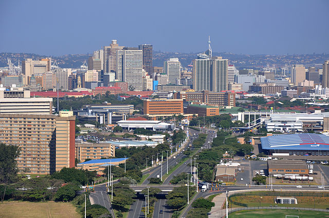
Afrikaans: Uitsig vanaf die 106m-hoë platform op die spanboog oor die Moses Mabhidastadion in Stamford Hill-voorstad, Durban. Dit verskaf hier 'n suidwaartse blik oor die M12-toegangsroete na die besigheidsdistrik van Durban-Sentraal. Die enkelkajuit SkyCar neem twee minute om op die staalspoor boontoe te ry, en dit kan op eie gewig weer na die grondstasie terugkeer in geval van 'n kragonderbreking. Die voorstad Stamford Hill beslaan die voorgrond weerskante van die M12, Durban-Sentraal lê daaragter, met Bayhead se houerhyskrane ook sigbaar, terwyl die Bluff die agtergrond vorm.
Deutsch: Blick nach Süden von der 106 Meter hohen Plattform auf dem Bogen des Moses Mabhida Stadions mit dem zentralen Geschäftsviertel von Durban, Südafrika. Die SkyCar-Einzelkabine benötigt zwei Minuten, um die Stahlschiene nach oben zu fahren, und bei einem Stromausfall kann sie mit ihrem Eigengewicht zur unteren Station hinunterfahren.
English: Southward view from the 106m high platform on the arch of the Moses Mabhida Stadium in Stamford Hill suburb, looking along the M12 route towards the business district of Durban Central, |
| 日期 | |
| 来源 | 自己的作品: Hansueli Krapf (User Simisa (留言 · 贡献)) |
| 作者 |
Hansueli Krapf 本文件使用Commonist. |
| 授权 (二次使用本文件) |
我,本作品著作权人,特此采用以下许可协议发表本作品: 本文件采用知识共享署名-相同方式共享 3.0 未本地化版本许可协议授权。
|
| 相机位置 | | 在以下服务上查看本图像和附近其他图像: OpenStreetMap |
|---|
许可协议
| 註解 | 該圖片含有註解:在維基媒體共享資源上查看註解 |
文件历史
点击某个日期/时间查看对应时刻的文件。
| 日期/时间 | 缩略图 | 大小 | 用户 | 备注 | |
|---|---|---|---|---|---|
| 当前 | 2011年7月17日 (日) 11:29 | | 4,197 × 2,787(6.32 MB) | Simisa |
文件用途
以下2个页面使用本文件:
全域文件用途
以下其他wiki使用此文件:
- af.wikipedia.org上的用途
- am.wikipedia.org上的用途
- ce.wikipedia.org上的用途
- en.wikipedia.org上的用途
- et.wikipedia.org上的用途
- fy.wikipedia.org上的用途
- he.wikipedia.org上的用途
- mhr.wikipedia.org上的用途
- nl.wikipedia.org上的用途
- nl.wikivoyage.org上的用途
- sh.wikipedia.org上的用途
- sq.wikipedia.org上的用途
- sr.wikipedia.org上的用途
- www.wikidata.org上的用途
- zu.wikipedia.org上的用途