File:2017 UK general election constituency map.svg

此SVG文件的PNG预览的大小:460 × 600像素。 其他分辨率:184 × 240像素 | 368 × 480像素 | 589 × 768像素 | 786 × 1,024像素 | 1,571 × 2,048像素 | 1,477 × 1,925像素。
原始文件 (SVG文件,尺寸为1,477 × 1,925像素,文件大小:97 KB)
Legend
Alliance Party (Northern Ireland)
Undeclared/Delayed
Regional boundaries
摘要
| 描述 |
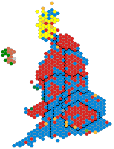
English: An alternative map showing the results of the 2017 UK General Election showing constituencies as equal area hexagons and approximate geographic location. |
| 日期 | |
| 来源 | 基于如下对象的个人作品: 2015 UK general election constituency map.svg 由 Ch1902 (previous version) |
| 作者 | Ch1902 |
| SVG开发 |
许可协议
| 我,本作品著作权人,释出本作品至公有领域。这适用于全世界。 在一些国家这可能不合法;如果是这样的话,那么: 我无条件地授予任何人以任何目的使用本作品的权利,除非这些条件是法律规定所必需的。 |
文件历史
点击某个日期/时间查看对应时刻的文件。
| 日期/时间 | 缩略图 | 大小 | 用户 | 备注 | |
|---|---|---|---|---|---|
| 当前 | 2017年6月10日 (六) 11:27 | | 1,477 × 1,925(97 KB) | Ch1902 | Kensington update |
| 2017年6月9日 (五) 10:28 |  | 1,477 × 1,925(97 KB) | Ch1902 | Updates | |
| 2017年6月9日 (五) 10:19 |  | 1,477 × 1,925(97 KB) | Ch1902 | Updates | |
| 2017年6月9日 (五) 09:52 |  | 1,477 × 1,925(97 KB) | Ch1902 | Updates | |
| 2017年6月9日 (五) 09:24 |  | 1,477 × 1,925(96 KB) | Ch1902 | Updates | |
| 2017年6月9日 (五) 08:47 |  | 1,477 × 1,925(96 KB) | Ch1902 | Updates | |
| 2017年6月9日 (五) 08:29 |  | 1,477 × 1,925(96 KB) | Ch1902 | Updates | |
| 2017年6月9日 (五) 07:54 |  | 1,477 × 1,925(96 KB) | Ch1902 | Updates | |
| 2017年6月8日 (四) 08:13 |  | 1,477 × 1,925(96 KB) | Ch1902 | ==Legend== {{Legend|#0087dc|Conservative}} {{Legend|#dc241f|Labour}} {{Legend|#fdbb30|Liberal Democrats}} {{Legend|#6ab023|[[w:Green_Party_of_England_and_Wales|Green Par... |
文件用途
以下页面使用本文件:
全域文件用途
以下其他wiki使用此文件:
- de.wikipedia.org上的用途
- en.wikipedia.org上的用途
- fr.wikipedia.org上的用途
- ga.wikipedia.org上的用途
- hu.wikipedia.org上的用途
- ms.wikipedia.org上的用途
- ru.wikipedia.org上的用途
- vi.wikipedia.org上的用途