File:Amazonie deforestation.jpg
本预览的尺寸:755 × 600像素。 其他分辨率:302 × 240像素 | 604 × 480像素 | 778 × 618像素。
原始文件 (778 × 618像素,文件大小:398 KB,MIME类型:image/jpeg)
摘要
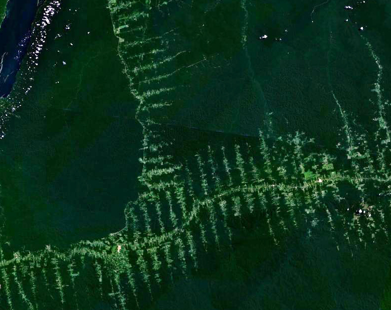
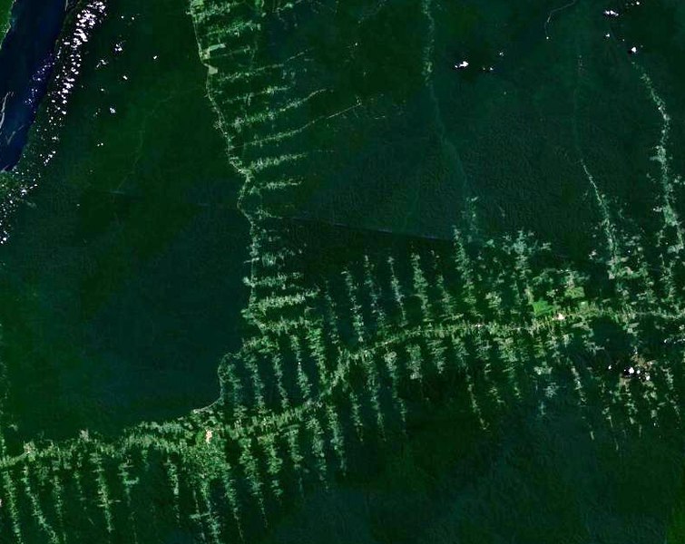
English: Deforestation in Amazonia, seen from satellite. The roads in the forest follow a typical "fish bone" pattern
Français : Déforestation en Amazonie, vu depuis un satellite. Les routes tracées dans la forêt suivent un motif caractéristique similaire à des arêtes de poisson
Deutsch: Entwaldung in Amazonien, aufgenommen vom Satelliten. Die in den Wald getriebenen Schneisen ergeben ein charakteristisches Fischgrätenmuster
许可协议
| 本文件完全由NASA创作,在美国属于公有领域。根据NASA的版权方针,NASA的材料除非另有声明否则不受版权保护。(参见Template:PD-USGov/zh、NASA版权方针页面或JPL图片使用方针。) | ||
 |
警告:
|
文件历史
点击某个日期/时间查看对应时刻的文件。
| 日期/时间 | 缩略图 | 大小 | 用户 | 备注 | |
|---|---|---|---|---|---|
| 当前 | 2006年9月20日 (三) 20:02 | | 778 × 618(398 KB) | Dake~commonswiki | {{en|Deforestation in Amazonia, seen from satellite. The roads in the forest follow a typical "fishbone" pattern}} {{fr|Déforestation en Amazonie, vu depuis un satellite. Les routes tracées dans la forêt suivent un motif caractéristique similaire à |
文件用途
没有页面链接到本图像。
全域文件用途
以下其他wiki使用此文件:
- ar.wikipedia.org上的用途
- bn.wikipedia.org上的用途
- ca.wikipedia.org上的用途
- chr.wikipedia.org上的用途
- de.wikipedia.org上的用途
- el.wikipedia.org上的用途
- en.wikipedia.org上的用途
- eo.wikipedia.org上的用途
- es.wikipedia.org上的用途
- eu.wikipedia.org上的用途
- fr.wikipedia.org上的用途
- gu.wikipedia.org上的用途
- id.wikipedia.org上的用途
- ja.wikipedia.org上的用途
- nl.wikipedia.org上的用途
- pa.wikipedia.org上的用途
- pl.wikipedia.org上的用途
- pt.wikipedia.org上的用途
- ro.wikipedia.org上的用途
- ru.wikipedia.org上的用途
- sl.wikipedia.org上的用途
- sq.wikipedia.org上的用途
- ta.wikipedia.org上的用途
- tr.wikipedia.org上的用途
- vi.wikipedia.org上的用途