File:Anatolia1200.png
此为最大尺寸。
Anatolia1200.png (642 × 430像素,文件大小:86 KB,MIME类型:image/png)

|
此historical map图片可使用矢量图形重新创建为SVG文件。这具有很多好处;更多信息请参见共享资源:待清理媒体。如果存在此图片的SVG格式,请将其上传,然后将此模板替换为
{{vector version available|新图片名称}}。
建议您将SVG命名为“Anatolia1200.svg”,这样在使用Vector version available(或Vva)模板时就不需要填写新图片名称参数。 |
摘要
| 描述 |
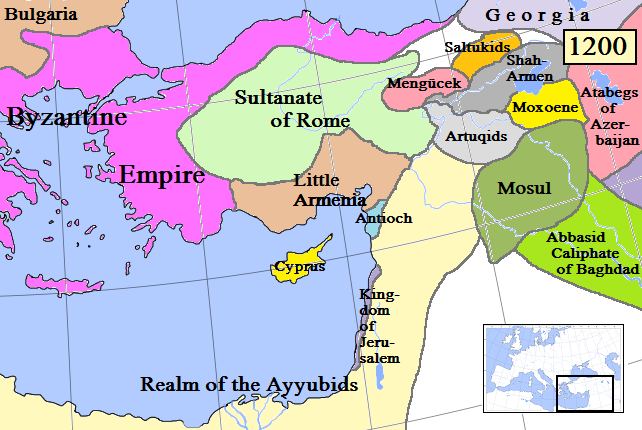
English: Map of Anatolia and some surrounding regions in AD 1200.
(Partially based on Euratlas map of Europe, 1200.) |
| 日期 | |
| 来源 | 自己的作品 |
| 作者 | Gabagool |
| 其他版本 |
许可协议
我,本作品著作权人,特此采用以下许可协议发表本作品:
本文件采用知识共享署名 3.0 未本地化版本许可协议授权。
- 您可以自由地:
- 共享 – 复制、发行并传播本作品
- 修改 – 改编作品
- 惟须遵守下列条件:
- 署名 – 您必须对作品进行署名,提供授权条款的链接,并说明是否对原始内容进行了更改。您可以用任何合理的方式来署名,但不得以任何方式表明许可人认可您或您的使用。
文件历史
点击某个日期/时间查看对应时刻的文件。
| 日期/时间 | 缩略图 | 大小 | 用户 | 备注 | |
|---|---|---|---|---|---|
| 当前 | 2009年4月19日 (日) 15:55 | | 642 × 430(86 KB) | Gabagool | Added more names to states. Cyprus now yellow to match other maps better. |
| 2009年4月17日 (五) 22:37 |  | 642 × 430(84 KB) | Gabagool | Extended Shah-Armen area per [http://en.wikipedia.org/wiki/Sassoun] ("The region was later ruled by the Mamikonian dynasty from around 772 until 1189/1190, when the Mamikonians moved to Cilicia after being dispossessed by Shah-Armen.") New Armenia -> Litt | |
| 2009年4月2日 (四) 23:54 |  | 642 × 430(84 KB) | Gabagool | {{Information |Description={{en|1=Map of Anatolia and some surrounding regions in AD 1200. (Partially based on Euratlas map of Europe, 1200.)}} |Source=Own work by uploader |Author=Gabagool |Date=2009-04-03 |Permission= |other_versions= |
文件用途
以下页面使用本文件:
全域文件用途
以下其他wiki使用此文件:
- ar.wikipedia.org上的用途
- ast.wikipedia.org上的用途
- azb.wikipedia.org上的用途
- az.wikipedia.org上的用途
- be.wikipedia.org上的用途
- de.wikipedia.org上的用途
- el.wikipedia.org上的用途
- en.wikipedia.org上的用途
- eo.wikipedia.org上的用途
- es.wikipedia.org上的用途
- et.wikipedia.org上的用途
- fa.wikipedia.org上的用途
- fr.wikipedia.org上的用途
- gl.wikipedia.org上的用途
- hy.wikipedia.org上的用途
- hyw.wikipedia.org上的用途
- it.wikipedia.org上的用途
- ja.wikipedia.org上的用途
- ka.wikipedia.org上的用途
- kk.wikipedia.org上的用途
- ko.wikipedia.org上的用途
- lt.wikipedia.org上的用途
- ml.wikipedia.org上的用途
- nl.wikipedia.org上的用途
- no.wikipedia.org上的用途
- pnb.wikipedia.org上的用途
- pt.wikipedia.org上的用途
- ro.wikipedia.org上的用途
- ru.wikipedia.org上的用途
查看本文件的更多全域用途。