File:Apsley house on an 1869 Ordnance Survey Map.JPG
此为最大尺寸。
Apsley_house_on_an_1869_Ordnance_Survey_Map.JPG (500 × 492像素,文件大小:79 KB,MIME类型:image/jpeg)

|
此文件是通过机器人脚本从en.wikipedia移动到维基共享资源的。来源中的所有信息均已保留,但仍需要人工的审阅。部分或所有的信息可能会出现在错误的区域;只有在经过审阅并修正需改正的错误后,此文件的相关信息才能视为可使用。当审阅结束后,请移除本模板,更详细的信息参见下方。 现在就开始检查! |
| 描述 |
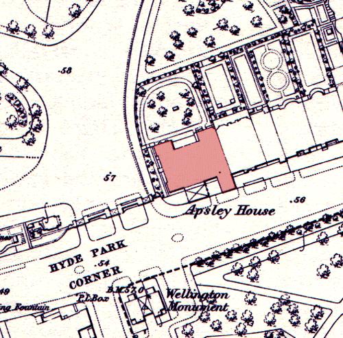
English: Apsley House on an 1869 Ordnance Survey map, showing its position at the end of a terrace. The neighbouring houses were demolished in the post World War II period to allow Park Lane to be straightened and widened. The Wellington Monument has been moved since this time. |
| 日期 | 2005年5月15日 (原始上传日期) |
| 来源 | 本檔案是由Oxyman使用CommonsHelper,從en.wikipedia轉移到維基共享資源。 |
| 作者 | 原上传者为英语维基百科的Oliver Chettle |
许可协议
這一創作於英國管轄區內的作品現在位於公有領域。
其原因是以下之一:
HMSO已經宣布,皇家版權到期適用於全世界範圍(參考:HMSO Email Reply)
|
 |
原始上传日志
原始描述頁面位於這裡。下列使用者名稱均來自en.wikipedia。
- 2005-05-15 08:53 Oliver Chettle 500×492× (80749 bytes) Apsley House on an 1869 [[Ordnance Survey]] map, showing its position at the end of a terrace. The neighbouring houses were demolished in the post [[World War II]] period to allow [[Park Lane]] to be widened. The [[Wellington Monument]] has been moved sin
文件历史
点击某个日期/时间查看对应时刻的文件。
| 日期/时间 | 缩略图 | 大小 | 用户 | 备注 | |
|---|---|---|---|---|---|
| 当前 | 2009年10月5日 (一) 23:23 | | 500 × 492(79 KB) | File Upload Bot (Magnus Manske) | {{BotMoveToCommons|en.wikipedia|year={{subst:CURRENTYEAR}}|month={{subst:CURRENTMONTHNAME}}|day={{subst:CURRENTDAY}}}} {{Information |Description={{en|Apsley House on an 1869 en:Ordnance Survey map, showing its position at the end of a terrace. The |
文件用途
以下页面使用本文件:
全域文件用途
以下其他wiki使用此文件:
- ar.wikipedia.org上的用途
- en.wikipedia.org上的用途
- es.wikipedia.org上的用途
- fr.wikipedia.org上的用途
- ja.wikipedia.org上的用途