File:Ashkelon1870s.jpg

本预览的尺寸:800 × 501像素。 其他分辨率:320 × 200像素 | 640 × 401像素 | 1,024 × 642像素 | 1,280 × 802像素 | 1,877 × 1,176像素。
原始文件 (1,877 × 1,176像素,文件大小:500 KB,MIME类型:image/jpeg)
摘要
| 描述 |
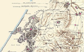
English: Portion of map produced by the Survey of Western Palestine, first published in 1880 by the Committee of the Palestine Exploration Fund. The editor, Walter Besant, died in 1901. This portion was made by the uploader out of portions of three sheets of the original map.
עברית: מפת הקרן לחקר ארץ ישראל לאזור אשקלון, משנת 1880 |
| 日期 | |
| 来源 | map produced by the Survey of Western Palestine, first published in 1880 by the Committee of the Palestine Exploration Fund |
| 作者 | Walter Besant, died in 1901 |
许可协议
|
这是一个平面公有领域艺术品的忠实摄影副本。原艺术品本身因为下列原因属于公有领域:
维基媒体基金会的官方立场认为:“对平面公有领域艺术品的忠实再制作品也属于公有领域。”
因此,可以认为此摄影副本在美国也属于公有领域。在其他司法管辖区,再利用此内容可能存在限制;参见再利用PD-Art照片了解详细信息。 | ||||
文件历史
点击某个日期/时间查看对应时刻的文件。
| 日期/时间 | 缩略图 | 大小 | 用户 | 备注 | |
|---|---|---|---|---|---|
| 当前 | 2007年5月27日 (日) 09:43 | | 1,877 × 1,176(500 KB) | Zero0000 | == Summary == Portion of map produced by the Survey of Western Palestine, first published in 1880 by the Committee of the Palestine Exploration Fund. The editor, Walter Besant, died in 1901. This portion was made by the uploader out of portions of three |
文件用途
以下页面使用本文件:
全域文件用途
以下其他wiki使用此文件:
- de.wikipedia.org上的用途
- en.wikipedia.org上的用途
- es.wikipedia.org上的用途
- he.wikipedia.org上的用途
- hr.wikipedia.org上的用途
- it.wikipedia.org上的用途
- lv.wikipedia.org上的用途
- pl.wikipedia.org上的用途
- www.wikidata.org上的用途