File:Azores old map.jpg

本预览的尺寸:800 × 563像素。 其他分辨率:320 × 225像素 | 640 × 450像素 | 1,024 × 720像素 | 1,280 × 900像素 | 2,104 × 1,480像素。
原始文件 (2,104 × 1,480像素,文件大小:678 KB,MIME类型:image/jpeg)
摘要

|
此old map图片可使用矢量图形重新创建为SVG文件。这具有很多好处;更多信息请参见共享资源:待清理媒体。如果存在此图片的SVG格式,请将其上传,然后将此模板替换为
{{vector version available|新图片名称}}。
建议您将SVG命名为“Azores old map.svg”,这样在使用Vector version available(或Vva)模板时就不需要填写新图片名称参数。 |


| 描述 |
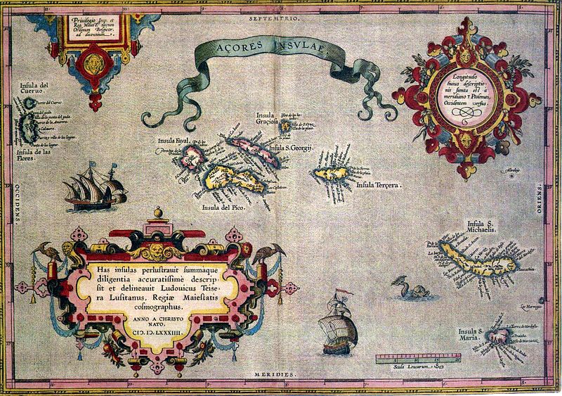
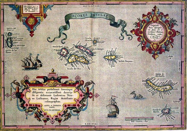
English: Sixteenth-century map of Azores. Legend, in Latin: "Has insulas perlustrauit summàque diligentia accuratissimè descripsit et delineauit Ludovicus Teisera Lusitanus, Regiæ Maiestatis cosmographus. ANNO A CHRISTO NATO, M.D.LXXXIIII" ("These islands were illustrated and described with great diligence and drawn by the Portuguese Luís Teixeira, his royal majesty's cartographer, AD 1584.") Deutsch: alte Karte der Azoren Português: "Açores Insulae" ("Ilhas dos Açores"), Luís Teixeira, c. 1584. A legenda, em latim - "Has insulas perlustrauit summàque diligentia accuratissimè descripsit et delineauit Ludovicus Teisera Lusitanus, Regiæ Maiestatis cosmographus. ANNO A CHRISTO NATO, M.D.LXXXIIII" -, pode ser traduzida livremente como: "Estas ilhas foram percorridas com a maior diligência, e com todo o cuidado as descreveu o português Luís Teixeira, cosmógrafo da Majestade Real. Ano do nascimento de Cristo de 1584." |
| 日期 | |
| 来源 | see above |
| 作者 | Abraham Ortelius |
许可协议
|
这是一个平面公有领域艺术品的忠实摄影副本。原艺术品本身因为下列原因属于公有领域:
维基媒体基金会的官方立场认为:“对平面公有领域艺术品的忠实再制作品也属于公有领域。” 因此,可以认为此摄影副本在美国也属于公有领域。在其他司法管辖区,再利用此内容可能存在限制;参见再利用PD-Art照片了解详细信息。 {{PD-Art}} template without license parameter: please specify why the underlying work is public domain in both the source country and the United States
(Usage: {{PD-Art|1=|deathyear=''year of author's death''|country=''source country''}}, where parameter #1 can be PD-old-auto, PD-old-auto-expired, PD-old-auto-1996, PD-old-100 or similar. See Commons:Multi-license copyright tags for more information.) | ||||
文件历史
点击某个日期/时间查看对应时刻的文件。
| 日期/时间 | 缩略图 | 大小 | 用户 | 备注 | |
|---|---|---|---|---|---|
| 当前 | 2005年7月17日 (日) 06:59 | | 2,104 × 1,480(678 KB) | Nataraja~commonswiki | |
| 2005年7月17日 (日) 02:16 |  | 2,104 × 1,480(635 KB) | Angrense | Abraham Ortelius map of the Azores (c. 1585). {{PD}} Category:Azores |
文件用途
以下页面使用本文件:
全域文件用途
以下其他wiki使用此文件:
- als.wikipedia.org上的用途
- an.wikipedia.org上的用途
- ca.wikipedia.org上的用途
- da.wikipedia.org上的用途
- de.wikipedia.org上的用途
- el.wikipedia.org上的用途
- en.wikipedia.org上的用途
- eo.wikipedia.org上的用途
- es.wikipedia.org上的用途
- fa.wikipedia.org上的用途
- fi.wikipedia.org上的用途
- fr.wikipedia.org上的用途
- gl.wikipedia.org上的用途
- id.wikipedia.org上的用途
- is.wikipedia.org上的用途
- it.wikipedia.org上的用途
- la.wikipedia.org上的用途
- mk.wikipedia.org上的用途
- nds-nl.wikipedia.org上的用途
- nn.wikipedia.org上的用途
- no.wikipedia.org上的用途
- pt.wikipedia.org上的用途
- ru.wikipedia.org上的用途
- sh.wikipedia.org上的用途
查看本文件的更多全域用途。