File:Balkans850.png
此为最大尺寸。
Balkans850.png (628 × 517像素,文件大小:287 KB,MIME类型:image/png)
摘要
| 描述 |
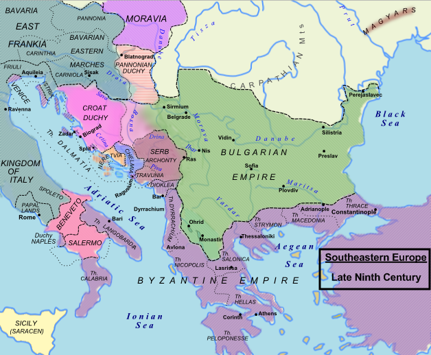
English: Balkans area year 850 according with the hungarian point of view. |
| 日期 | 2009年1月3日 (原始上传日期) |
| 来源 | P.M. Barford, The Early Slavs. Culture and Society in Early Medieval Eastern Europe, ISBN 0-8014-3977-9; John Fine, Jr., The Early Medieval Balkans, ISBN 0-472-08149-7; D. Hupchik, The Balkans from Constantinople to Communism. |
| 作者 | Hxseek (talk) 03:42, 15 January 2009 (UTC) |
| 授权 (二次使用本文件) |
自己的作品 |
许可协议
本文件采用知识共享署名-相同方式共享 3.0 未本地化版本许可协议授权。
- 您可以自由地:
- 共享 – 复制、发行并传播本作品
- 修改 – 改编作品
- 惟须遵守下列条件:
- 署名 – 您必须对作品进行署名,提供授权条款的链接,并说明是否对原始内容进行了更改。您可以用任何合理的方式来署名,但不得以任何方式表明许可人认可您或您的使用。
- 相同方式共享 – 如果您再混合、转换或者基于本作品进行创作,您必须以与原先许可协议相同或相兼容的许可协议分发您贡献的作品。
原始上传日志
原始描述頁面位於這裡。下列使用者名稱均來自en.wikipedia。
- 2009-02-07 09:40 Hxseek 628×517× (293955 bytes)
- 2009-02-04 06:17 Hxseek 600×450× (649117 bytes)
- 2009-01-15 01:32 Hxseek 619×450× (587789 bytes)
- 2009-01-03 01:11 Hxseek 598×456× (568416 bytes)
文件历史
点击某个日期/时间查看对应时刻的文件。
| 日期/时间 | 缩略图 | 大小 | 用户 | 备注 | |
|---|---|---|---|---|---|
| 当前 | 2023年8月8日 (二) 10:36 | | 628 × 517(287 KB) | OrionNimrod | Reverted to version as of 10:50, 23 June 2023 (UTC) explanation on the talk page, do not falsify constantly history maps |
| 2023年8月5日 (六) 14:07 |  | 628 × 517(274 KB) | Claude Zygiel | Reverted to version as of 11:38, 1 January 2020 (UTC) : see explanation in the discussion file. | |
| 2023年6月23日 (五) 10:50 |  | 628 × 517(287 KB) | OrionNimrod | Reverted the false map to the original version: there was no Wallachia in 8-900, it established in 1330: (https://en.wikipedia.org/wiki/Wallachia) | |
| 2023年5月6日 (六) 05:52 |  | 628 × 517(274 KB) | Targatron | Reverted to version as of 12:05, 22 January 2022 (UTC) | |
| 2023年4月26日 (三) 11:06 |  | 628 × 517(287 KB) | OrionNimrod | Reverted to version as of 22:36, 30 July 2010 (UTC) original version, there was no Wallachian in 8-900 | |
| 2022年1月22日 (六) 12:05 |  | 628 × 517(274 KB) | Targatron | Reverted to version as of 11:38, 1 January 2020 (UTC) | |
| 2022年1月22日 (六) 11:20 |  | 628 × 517(287 KB) | Targatron | Reverted to version as of 20:20, 7 March 2018 (UTC) Using of solt and gold mines in Transylvania during the middle ages started after 1050. This map shows Southeast Europe in 9th century. | |
| 2020年1月1日 (三) 11:38 |  | 628 × 517(274 KB) | Santasa99 | Reverted to version as of 09:09, 3 September 2014 (UTC) relatively accurate | |
| 2018年5月22日 (二) 14:38 |  | 628 × 517(285 KB) | Julieta39 | There was no Wallachia in 850, but Etelköz and the Bulgarian control over the gold mines of Bihar and over the low-danubian plain, yes. | |
| 2018年3月7日 (三) 20:20 |  | 628 × 517(287 KB) | Fakirbakir | Reverted to version as of 10:41, 2 February 2017 (UTC) |
文件用途
以下2个页面使用本文件:
全域文件用途
以下其他wiki使用此文件:
- ar.wikipedia.org上的用途
- azb.wikipedia.org上的用途
- az.wikipedia.org上的用途
- be.wikipedia.org上的用途
- bg.wikipedia.org上的用途
- bn.wikipedia.org上的用途
- ca.wikipedia.org上的用途
- cs.wikipedia.org上的用途
- da.wikipedia.org上的用途
- de.wikipedia.org上的用途
- de.wikibooks.org上的用途
- el.wikipedia.org上的用途
- en.wikipedia.org上的用途
查看本文件的更多全域用途。