File:Basin of Lop Nur 90.25E, 40.10N, Desert of Lop, Kum Tagh and Astin Tagh.jpg

本预览的尺寸:800 × 520像素。 其他分辨率:320 × 208像素 | 640 × 416像素 | 1,024 × 666像素 | 1,280 × 832像素 | 2,539 × 1,651像素。
原始文件 (2,539 × 1,651像素,文件大小:2.5 MB,MIME类型:image/jpeg)
摘要
| 描述 |
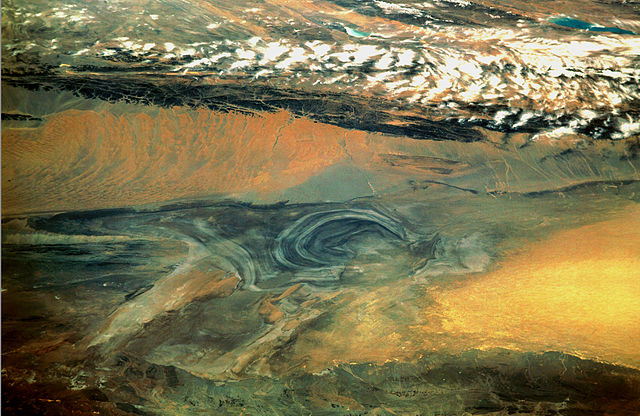
English: China, Xinjiang, desert Lop Nur. Satellite picture of the Basin of the formerly sea Lop Nur in the Desert of Lop. In the foreground Kuruktagh, in the background Kumtagh and Astintagh. A duststorm is blowing to the west over the Desert of Lop. Two lakes appear in a break in the clouds covering the Plateau of Astintagh. Visible are elongated Ayakkum Hu Lake south-southwest of Lop Nur and small blue-green Gas Hu Lake.
Deutsch: China, Xinjiang, Wüste Lop Nor. Satellitenaufnahme von dem mittleren Teil des Seebeckens Lop Nor und der Wüste Lop Nor, über die ein Sandsturm hinweggeht. Im Vordergrund sieht man die Hänge des Gebirges Kuruktagh, im Hintergrund die Hänge des Kumtagh und die Hochebene des Astintagh, auf der rechts der See Ayakkum Hu und links der kleinere See Gas Hu liegen. Blick von Norden Richtung Süden. |
| 日期 | |
| 来源 | NASA Mission: STS047, Roll-Frame 151 – 26, File name STS047-151-26.JPG. [1]. See also: [2]. |
| 作者 |
English: NASA. Image courtesy of Earth Sciences and Image Analysis Laboratory, NASA Johnson Space Center. Color adjusting of this image (using Adobe Photoshop 6.0): Michael Gaebler, 02. March 2006, own work, all rights released (Public domain).
Deutsch: Zugrunde liegt ein noch nicht farbrichtiges Astronauten-Foto der NASA. Diese Fotografie wurde von Michael Gaebler am 02. März 2006 im RGB-Modus mit Adobe Photoshop 6.0 mit Farb- und Tonwertkorrekturen überarbeitet. |
| 授权 (二次使用本文件) |
PD-USGov-NASA |
![[1]](ftp://eol.jsc.nasa.gov/EFS_highres_STS047_STS047-151-26.JPG)
本图像或视频收录于美国国家航空航天局 (NASA)某个部门,其照片编号是: STS047-151-26 此标签不表示文件的著作权状态。任何文件在附有此标签的同時还需要一个有效的著作权标签。请参阅许可协议说明页面以了解更多信息。 其他语言:
|
许可协议
| 本文件完全由NASA创作,在美国属于公有领域。根据NASA的版权方针,NASA的材料除非另有声明否则不受版权保护。(参见Template:PD-USGov/zh、NASA版权方针页面或JPL图片使用方针。) | ||
 |
警告:
|
文件历史
点击某个日期/时间查看对应时刻的文件。
| 日期/时间 | 缩略图 | 大小 | 用户 | 备注 | |
|---|---|---|---|---|---|
| 当前 | 2006年3月10日 (五) 22:46 | | 2,539 × 1,651(2.5 MB) | Michael Gäbler | {{Information| |Description = en: China, Xinjiang, desert Lop Nur. Satellite picture of the Basin of the formerly sea Lop Nur in the Desert of Lop. In the foreground Kuruktagh, in the background Kumtagh and Astintagh. A duststorm is blowing to th |
文件用途
以下页面使用本文件:
全域文件用途
以下其他wiki使用此文件:
- az.wikipedia.org上的用途
- de.wikipedia.org上的用途
- en.wikipedia.org上的用途
- en.wikibooks.org上的用途
- es.wikipedia.org上的用途
- fa.wikipedia.org上的用途
- frr.wikipedia.org上的用途
- he.wikivoyage.org上的用途
- hi.wikipedia.org上的用途
- id.wikipedia.org上的用途
- it.wikipedia.org上的用途
- ja.wikipedia.org上的用途
- ka.wikipedia.org上的用途
- ko.wikipedia.org上的用途
- mn.wikipedia.org上的用途
- pa.wikipedia.org上的用途
- pl.wikipedia.org上的用途
- pnb.wikipedia.org上的用途
- ro.wikipedia.org上的用途
- sh.wikipedia.org上的用途
- sl.wikipedia.org上的用途
- sr.wikipedia.org上的用途
- sv.wikipedia.org上的用途
- te.wikipedia.org上的用途
- tr.wikipedia.org上的用途
- ug.wikipedia.org上的用途
- uk.wikipedia.org上的用途
- ur.wikipedia.org上的用途
- www.wikidata.org上的用途