File:Beylik of Aydın 1315-1375.png

本预览的尺寸:800 × 394像素。 其他分辨率:320 × 157像素 | 640 × 315像素 | 1,024 × 504像素 | 1,280 × 630像素 | 2,560 × 1,259像素 | 8,923 × 4,390像素。
原始文件 (8,923 × 4,390像素,文件大小:1.22 MB,MIME类型:image/png)
摘要
Look also: User:Berkaysnklf/Turkey
.
.
| 描述 |
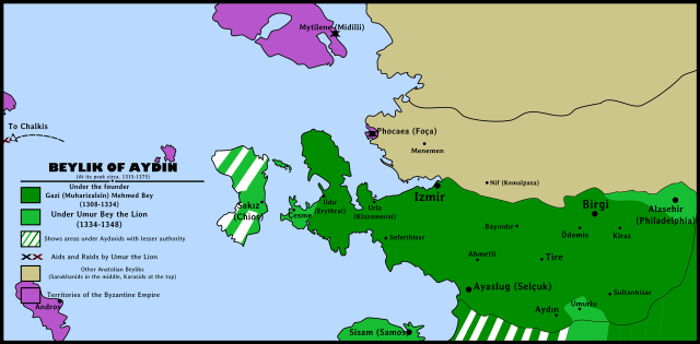
English: Beylik of Aydın(Aydınids)'s map during its peak years between 1315 and 1375. Beylik of Aydın Map highlighting: Borders under Gazi Mehmed Bey Borders after conquests under Umur Bey the Lion Byzantine Empire territories Other Western Anatolian Beyliks Black "X" showing Umur Bey's aids Red "X" showing Umur Bey's raids Türkçe: Aydınoğulları Beyliği'nin en parlak dönemleri olan 1315-1375 yılları arasındaki sınırlarını gösteren siyasi harita. Aydınoğulları Beyliği Haritası İçeriği: Gazi Mehmet Bey döneminde sınırlar Umur Bey fetihleri sonrasında sınırlar Bizans İmparatorluğu toprakları Diğer Batı Anadolu Beylikleri Siyah "X" Umur Bey'in yardımlarını gösterirKırmızı "X" Umur Bey'in yağmalarını gösterir |
||||||
| 日期 | |||||||
| 来源 | 自己的作品 | ||||||
| 作者 |
|
||||||
| 授权 (二次使用本文件) |
|
||||||
| 其他版本 |
|

许可协议
我,本作品著作权人,特此采用以下许可协议发表本作品:
文件历史
点击某个日期/时间查看对应时刻的文件。
| 日期/时间 | 缩略图 | 大小 | 用户 | 备注 | |
|---|---|---|---|---|---|
| 当前 | 2015年1月23日 (五) 22:17 | | 8,923 × 4,390(1.22 MB) | BRKY24 | User created page with UploadWizard |
文件用途
以下页面使用本文件:
全域文件用途
以下其他wiki使用此文件:
- als.wikipedia.org上的用途
- ar.wikipedia.org上的用途
- bg.wikipedia.org上的用途
- cs.wikipedia.org上的用途
- de.wikipedia.org上的用途
- en.wikipedia.org上的用途
- fr.wikipedia.org上的用途
- pt.wikipedia.org上的用途
- sl.wikipedia.org上的用途
- www.wikidata.org上的用途