File:Boundaries of the Okinawan Languages.svg

此SVG文件的PNG预览的大小:736 × 600像素。 其他分辨率:295 × 240像素 | 589 × 480像素 | 942 × 768像素 | 1,257 × 1,024像素 | 2,513 × 2,048像素。
原始文件 (SVG文件,尺寸为800 × 652像素,文件大小:21 KB)
摘要
| 描述 |
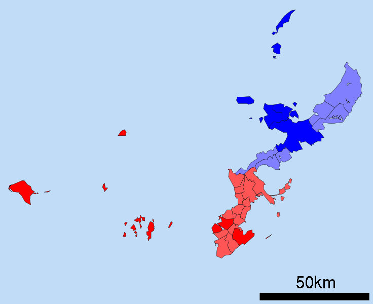
English: A map of the Okinawan Islands displaying the distribution of the Northern Okinawan Language (Kunigami) in blue, and the South-Central Okinawan Language (Shuri-Naha) in red. The darker areas represent regions that have been officially classified by the following sources:
|
| 日期 | (UTC) |
| 来源 | Map_of_Okinawa_Prefecture_Ja.svg |
| 作者 |
|
| 这是一张修改过的图片,这意味着它已在原版本的基础上通过软件进行了编辑,改动内容:Removed the Daito, Yaeyama, Miyako and Yonaguni islands. Changed all the links to point towards their English Wikipedia counterparts. Changed the colours on the map to demonstrate the Okinawan language boundaries.。其原始版本为:Map of Okinawa Prefecture Ja.svg。修改者: Io Katai。
|
许可协议
我,本作品著作权人,特此采用以下许可协议发表本作品:
| 本文件采用知识共享署名-相同方式共享 3.0 未本地化版本许可协议授权。 | ||
| ||
| 本许可协议标签作为GFDL许可协议更新的组成部分被添加至本文件。 |

|
已授权您依据自由软件基金会发行的无固定段落及封面封底文字(Invariant Sections, Front-Cover Texts, and Back-Cover Texts)的GNU自由文件许可协议1.2版或任意后续版本的条款,复制、传播和/或修改本文件。该协议的副本请见“GNU Free Documentation License”。 |
您可以选择您需要的许可协议。
原始上传日志
This image is a derivative work of the following images:
- File:Map_of_Okinawa_Prefecture_Ja.svg licensed with Cc-by-sa-3.0-migrated, GFDL
- 2008-04-30T00:12:31Z Krisgrotius 800x652 (14670 Bytes) {{Information| |Description= Map of Okinawa Prefecture, Japan. |Source= Japanese wiki [http://ja.wikipedia.org/wiki/%E7%94%BB%E5%83%8F:%E5%8C%85%E6%8B%AC%E8%87%AA%E6%B2%BB%E4%BD%93%E5%8C%BA%E7%94%BB%E5%9B%B3_47000.svg] |Da
Uploaded with derivativeFX
文件历史
点击某个日期/时间查看对应时刻的文件。
| 日期/时间 | 缩略图 | 大小 | 用户 | 备注 | |
|---|---|---|---|---|---|
| 当前 | 2010年12月25日 (六) 00:49 | | 800 × 652(21 KB) | Io Katai | fixed links |
| 2010年12月25日 (六) 00:47 |  | 800 × 652(21 KB) | Io Katai | Missed out on a few links | |
| 2010年12月25日 (六) 00:41 |  | 800 × 652(21 KB) | Io Katai | {{Information |Description=A map of the Okinawan Islands displaying the distribution of the Northern Okinawan Language (Kunigami) in blue, and the South-Central Okinawan Language (Shuri-Naha) in red. The darker areas represent regions that have been offic |
文件用途
全域文件用途
以下其他wiki使用此文件:
- ca.wikipedia.org上的用途
- cdo.wikipedia.org上的用途
- cs.wikipedia.org上的用途
- en.wikipedia.org上的用途
- et.wikipedia.org上的用途
- fa.wikipedia.org上的用途
- fi.wikipedia.org上的用途
- gd.wikipedia.org上的用途
- gl.wikipedia.org上的用途
- gn.wikipedia.org上的用途
- haw.wikipedia.org上的用途
- hu.wikipedia.org上的用途
- id.wikipedia.org上的用途
- incubator.wikimedia.org上的用途
- it.wikipedia.org上的用途
- ja.wikipedia.org上的用途
- ko.wikipedia.org上的用途
- ms.wikipedia.org上的用途
- pt.wikipedia.org上的用途
- ru.wikipedia.org上的用途
- sc.wikipedia.org上的用途
- simple.wikipedia.org上的用途
- sr.wikipedia.org上的用途
- sv.wikipedia.org上的用途
- th.wikipedia.org上的用途
- tr.wikipedia.org上的用途
- uk.wikipedia.org上的用途
- vi.wikipedia.org上的用途
- zh-min-nan.wikipedia.org上的用途