File:Brenda 1960-07-30 weather map.jpg
此为最大尺寸。
Brenda_1960-07-30_weather_map.jpg (600 × 578像素,文件大小:60 KB,MIME类型:image/jpeg)
摘要
| 描述 | ||||
| 日期 | ||||
| 来源 | NOAA Central Library Data Imaging Project | |||
| 作者 | NOAA Central Library, Silver Spring, Maryland | |||
| 授权 (二次使用本文件) |
|
文件历史
点击某个日期/时间查看对应时刻的文件。
| 日期/时间 | 缩略图 | 大小 | 用户 | 备注 | |
|---|---|---|---|---|---|
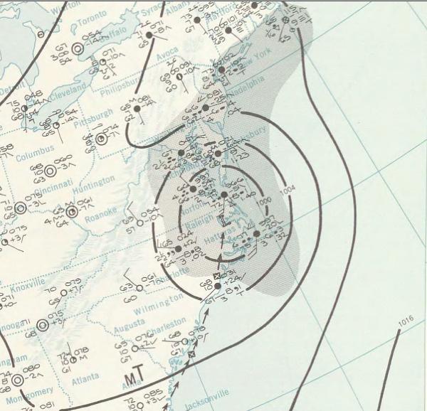
| 当前 | 2010年1月5日 (二) 18:20 | | 600 × 578(60 KB) | Juliancolton | {{Information |Description={{en|1=A July 30, 1960 weather map of a storm.}} |Source=http://docs.lib.noaa.gov/rescue/dwm/1960/19600730.djvu |Author=[http://docs.lib.noaa.gov/rescue/dwm/data_rescue_daily_weather_maps.html NOAA Central Library Data Imaging P |
文件用途
以下8个页面使用本文件:
全域文件用途
以下其他wiki使用此文件:
- en.wikipedia.org上的用途
- es.wikipedia.org上的用途
- fr.wikipedia.org上的用途
- pt.wikipedia.org上的用途
- ro.wikipedia.org上的用途
- vi.wikipedia.org上的用途