File:Burmese-Siamese war (1765-1767) map - EN - 001.jpg

本预览的尺寸:342 × 599像素。 其他分辨率:137 × 240像素 | 274 × 480像素 | 438 × 768像素 | 584 × 1,024像素 | 1,516 × 2,657像素。
原始文件 (1,516 × 2,657像素,文件大小:461 KB,MIME类型:image/jpeg)
摘要
| 描述 |
English:
ไทย:
|
| 日期 | |
| 来源 |
自己的作品
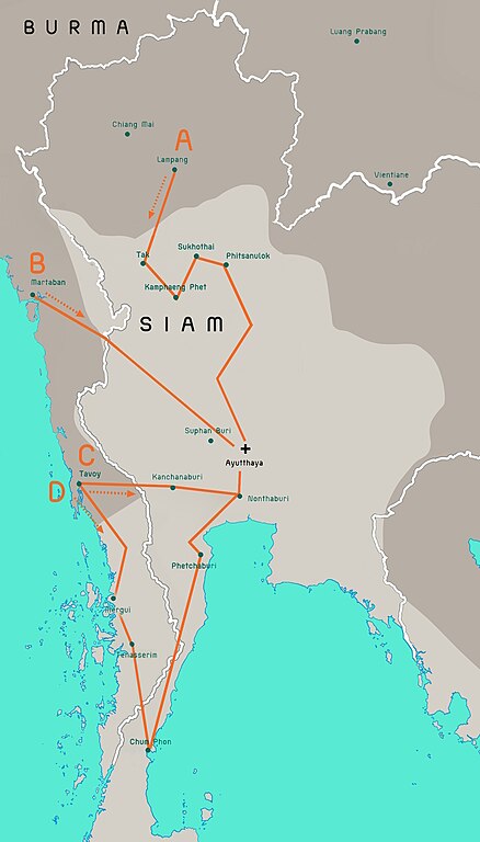
Terwiel, Bertrand. Thailand's Political History: From the 13th Century to Recent Times. Approximate boundaries of the six states that formed after Ayutthaya's destruction. |
| 作者 | Aristitleism |
| 其他版本 |
_map_-_TH_-_002.jpg) |
许可协议
我,本作品著作权人,特此采用以下许可协议发表本作品:
| 本作品采用知识共享CC0 1.0 通用公有领域贡献许可协议授权。 | |
| 采用本宣告发表本作品的人,已在法律允许的范围内,通过在全世界放弃其对本作品拥有的著作权法规定的所有权利(包括所有相关权利),将本作品贡献至公有领域。您可以复制、修改、传播和表演本作品,将其用于商业目的,无需要求授权。
|
en:Burmese–Siamese War (1765–1767)

|
此historical map图片可使用矢量图形重新创建为SVG文件。这具有很多好处;更多信息请参见共享资源:待清理媒体。如果存在此图片的SVG格式,请将其上传,然后将此模板替换为
{{vector version available|新图片名称}}。
建议您将SVG命名为“Burmese-Siamese war (1765-1767) map - EN - 001.svg”,这样在使用Vector version available(或Vva)模板时就不需要填写新图片名称参数。 |


_map_-_EN_-_001.jpg?uselang=zh)
_map_-_EN_-_001.jpg?uselang=zh)
_map_-_EN_-_001.jpg?action=history&uselang=zh)
_map_-_EN_-_001.jpg)
文件历史
点击某个日期/时间查看对应时刻的文件。
_map_-_EN_-_001.jpg&dir=prev)
_map_-_EN_-_001.jpg&offset=20110724171301)
_map_-_EN_-_001.jpg&offset=&limit=20)
_map_-_EN_-_001.jpg&offset=&limit=50)
_map_-_EN_-_001.jpg&offset=&limit=100)
_map_-_EN_-_001.jpg&offset=&limit=250)
_map_-_EN_-_001.jpg&offset=&limit=500)
| 日期/时间 | 缩略图 | 大小 | 用户 | 备注 | |
|---|---|---|---|---|---|
| 当前 | 2023年7月19日 (三) 08:29 | | 1,516 × 2,657(461 KB) | Yourlocallordandsavior | Based off the Siamese civil war borders from Terwiel's "Thailand's Political History: From the 13th Century to Recent Times". |
| 2023年7月12日 (三) 08:51 |  | 1,516 × 2,657(464 KB) | Yourlocallordandsavior | Major updated borders (riverine and land). | |
| 2023年3月3日 (五) 03:40 |  | 1,516 × 2,657(402 KB) | Yourlocallordandsavior | Added Phetchabun according to 17th century urban places map in "A History of Ayutthaya" by Baker and Phongpaichit. | |
| 2023年2月19日 (日) 04:45 |  | 1,516 × 2,657(403 KB) | Yourlocallordandsavior | Added Phimai, Phimai was where Prince Thepphiphit had his seat of power in the 1767-71 civil war. | |
| 2023年2月19日 (日) 02:46 |  | 1,516 × 2,657(404 KB) | Yourlocallordandsavior | . | |
| 2023年2月19日 (日) 01:27 |  | 1,516 × 2,657(406 KB) | Yourlocallordandsavior | Removed the Forest Mueang and adjusted borders. | |
| 2011年8月19日 (五) 17:23 |  | 1,516 × 2,657(1.05 MB) | Tiemianwusi | Changing the colour of the third territories (from pale blue to pale taupe) | |
| 2011年8月19日 (五) 15:47 |  | 1,516 × 2,657(1.05 MB) | Tiemianwusi | (1) Correcting boundaries, (2) Darker Burmese territories, (3) Recolouring third territories, (4) Correcting advance routes. | |
| 2011年7月25日 (一) 08:47 |  | 1,516 × 2,657(1.05 MB) | Tiemianwusi | "Margui" → "Mergui" | |
| 2011年7月24日 (日) 17:13 |  | 1,516 × 2,657(1.05 MB) | Tiemianwusi | Correcting territories |
文件用途
以下页面使用本文件:
全域文件用途
以下其他wiki使用此文件:
- ar.wikipedia.org上的用途
- en.wikipedia.org上的用途
- es.wikipedia.org上的用途
- it.wikipedia.org上的用途
- km.wikipedia.org上的用途
- my.wikipedia.org上的用途
- uk.wikipedia.org上的用途
- vi.wikipedia.org上的用途
- www.wikidata.org上的用途
_map_-_EN_-_001.jpg)