File:CSX Transportation system map.svg

此SVG文件的PNG预览的大小:800 × 457像素。 其他分辨率:320 × 183像素 | 640 × 366像素 | 1,024 × 585像素 | 1,280 × 731像素 | 2,560 × 1,463像素 | 1,400 × 800像素。
原始文件 (SVG文件,尺寸为1,400 × 800像素,文件大小:1.31 MB)
摘要
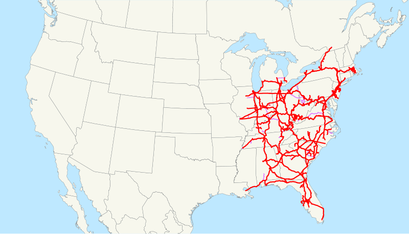
| 描述 | This is a map of CSX Transportation as of 2009, with trackage rights in purple. Some minor lines are missing. Email me if you would like a copy of the GIS data I created (modified from Bureau of Transportation Statistics North American Transportation Atlas Data) or if you see any errors. |
| 日期 | 2009年1月28日 (原始上传日期) |
| 来源 | 无法识别来源。根据版权声明推断为其自己的作品。 |
| 作者 | 无法识别作者。根据版权声明推断作者为NE2。 |
Note: The MBTA Worcester Line, the, Track 61, and some lines for South Coast Rail have since been sold to the Massachusetts Department of Transportation.
许可协议
| 我,本作品著作权人,释出本作品至公有领域。这适用于全世界。 在一些国家这可能不合法;如果是这样的话,那么: 我无条件地授予任何人以任何目的使用本作品的权利,除非这些条件是法律规定所必需的。 |
文件历史
点击某个日期/时间查看对应时刻的文件。
| 日期/时间 | 缩略图 | 大小 | 用户 | 备注 | |
|---|---|---|---|---|---|
| 当前 | 2009年2月23日 (一) 13:05 | | 1,400 × 800(1.31 MB) | NE2 | Changed the display of lines owned by the government for the purposes of passenger rail, so that if CSX is the primary freight operator it is not shown as trackage rights. |
| 2009年1月28日 (三) 13:53 |  | 1,400 × 800(1.29 MB) | NE2 | == Summary == This is a map of CSX Transportation as of 2009, with trackage rights in purple. Some minor lines are missing. Email me if you would like a copy of the GIS data I created (modified from Bureau |
文件用途
以下页面使用本文件:
全域文件用途
以下其他wiki使用此文件:
- da.wikipedia.org上的用途
- de.wikipedia.org上的用途
- en.wikipedia.org上的用途
- es.wikipedia.org上的用途
- fi.wikipedia.org上的用途
- fr.wikipedia.org上的用途
- hu.wikipedia.org上的用途
- id.wikipedia.org上的用途
- it.wikipedia.org上的用途
- ja.wikipedia.org上的用途
- ko.wikipedia.org上的用途
- nl.wikipedia.org上的用途
- no.wikipedia.org上的用途
- pt.wikipedia.org上的用途
- ru.wikipedia.org上的用途
- simple.wikipedia.org上的用途
- www.wikidata.org上的用途