File:Caucasus topo map-blank.svg

此SVG文件的PNG预览的大小:771 × 599像素。 其他分辨率:309 × 240像素 | 618 × 480像素 | 988 × 768像素 | 1,280 × 995像素 | 2,560 × 1,990像素 | 1,155 × 898像素。
原始文件 (SVG文件,尺寸为1,155 × 898像素,文件大小:4.43 MB)
摘要
| 描述 |
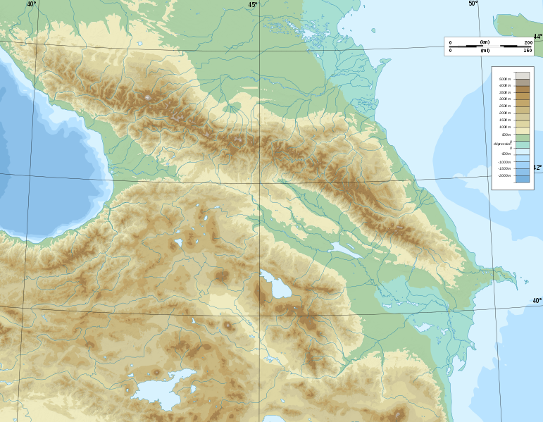
Deutsch: Topographische Karte von Kaukasien, französische Version English: Topographic map in French of Caucasus Français : Carte topographique en français du Caucase |
| 日期 | |
| 来源 |
English: Own work ; Topographic data from the NASA Shuttle Radar Topography Mission (SRTM3 v.2) (public domain) edited with 3DEM, reprojected in UTM with GDAL (GDAL), and vectorized with Inkscape ; UTM projection ; WGS84 datum ; shaded relief (composite image of N-W, W and N lightning positions) ; Reference used for the additional data : * Rivers, bathymetry : Demis add-on for World Wind (see the approval e-mail and the Demis forum) ; * coast : World data bank II ; Approximate scale of topographic data : 1:1,463,000 ; Note : The shaded relief is a raster image embedded in the SVG file. Français : Création personnelle ; Données topographiques de la NASA Shuttle Radar Topography Mission (SRTM3 v.2) (domaine public) éditées avec 3DEM, reprojetées en UTM avec GDAL et vectorisées avec Inkscape ; projection UTM ; WGS84 datum ; relief ombré (image composite d'éclairages du N-O, O et N) ; Références utilisées pour les données complémentaires : * Rivières, bathymétrie : Demis add-on for World Wind (cf. l'e-mail d'approbation de Demis et le Demis forum) ; * côtes : World data bank II ; Échelle approximative des données topographiques : 1:1 463 000 ; Note : Le relief ombré est une image bitmap embarquée dans le fichier SVG. Approximate geographic limits of the map (3' close) : * SW corner : 38°05'00"N – 39°33'00"E * SE corner : 38°05'00"N – 51°00'00"E * NE corner : 45°00'00"N – 51°00'00"E * NW corner : 45°00'00"N – 39°00'00"E |
| 作者 | Bourrichon - fr:Bourrichon) |
| 授权 (二次使用本文件) |
GFDL / Attribution and Share-Alike required |
| 其他版本 |
|


|
此SVG檔案包含可翻譯至您的語言的内嵌文字,可以使用任何可用SVG編輯器、文本編輯器或SVG翻譯工具來翻譯。詳情請見:關於翻譯SVG檔案。 |
许可协议
我,本作品著作权人,特此采用以下许可协议发表本作品:

|
已授权您依据自由软件基金会发行的无固定段落及封面封底文字(Invariant Sections, Front-Cover Texts, and Back-Cover Texts)的GNU自由文件许可协议1.2版或任意后续版本的条款,复制、传播和/或修改本文件。该协议的副本请见“GNU Free Documentation License”。 |
This file is licensed under the Creative Commons Attribution-Share Alike 4.0 International, 3.0 Unported, 2.5 Generic, 2.0 Generic and 1.0 Generic license.
- 您可以自由地:
- 共享 – 复制、发行并传播本作品
- 修改 – 改编作品
- 惟须遵守下列条件:
- 署名 – 您必须对作品进行署名,提供授权条款的链接,并说明是否对原始内容进行了更改。您可以用任何合理的方式来署名,但不得以任何方式表明许可人认可您或您的使用。
- 相同方式共享 – 如果您再混合、转换或者基于本作品进行创作,您必须以与原先许可协议相同或相兼容的许可协议分发您贡献的作品。
您可以选择您需要的许可协议。
文件历史
点击某个日期/时间查看对应时刻的文件。
| 日期/时间 | 缩略图 | 大小 | 用户 | 备注 | |
|---|---|---|---|---|---|
| 当前 | 2008年11月9日 (日) 17:16 | | 1,155 × 898(4.43 MB) | Bourrichon | |
| 2008年11月8日 (六) 15:59 |  | 1,155 × 898(4.43 MB) | Bourrichon | == Summary == {{Information |Description={{de|Topographische Karte von Kaukasien, französische Version}}{{en|Topographic map in French of Caucasus}}{{fr|Carte topographique en français du Caucase}} |Sou |
文件用途
以下5个页面使用本文件:
全域文件用途
以下其他wiki使用此文件:
- ar.wikipedia.org上的用途
- ast.wikipedia.org上的用途
- av.wikipedia.org上的用途
- az.wikipedia.org上的用途
- Azərbaycan dili
- Muğan düzü
- Araz
- Böyük Qafqaz
- Kür
- Göygöl (göl)
- Bazardüzü
- Şablon:Çay
- Ağrı dağı
- Qarayazı Dövlət Təbiət Qoruğu
- Göygöl Dövlət Təbiət Qoruğu
- İlisu Dövlət Təbiət Qoruğu
- Mingəçevir su anbarı
- Hacıqabul gölü
- Türyançay Dövlət Təbiət Qoruğu
- Talış dağları
- Kürəkçay
- Qabırrıçay
- Qanıxçay
- Sumqayıtçay
- İlandağ
- Göyçə gölü
- Göyəzən dağı
- Şablon:Yer xəritəsi
- Şablon:Yer xəritəsi/doc
- Şablon:Yer xəritəsi+
- Xınalıq dağı
- Qafqaz dağları
- Murovdağ
- Kəpəz dağı
- Sarısu gölü
- Böyükşor gölü
- Maralgöl
- Şablon:Su anbarı
- Şablon:Su anbarı/doc
- Candargöl
- Kazbek dağı
- Şirvan düzü
- Mil düzü
- Batabat gölü
- Beşbarmaq dağı
- Babazənən yüksəkliyi
查看本文件的更多全域用途。