File:Chagos large.png
本预览的尺寸:404 × 600像素。 其他分辨率:161 × 240像素 | 323 × 480像素 | 517 × 768像素 | 689 × 1,024像素 | 1,311 × 1,947像素。
原始文件 (1,311 × 1,947像素,文件大小:1.28 MB,MIME类型:image/png)
摘要
| 描述 |
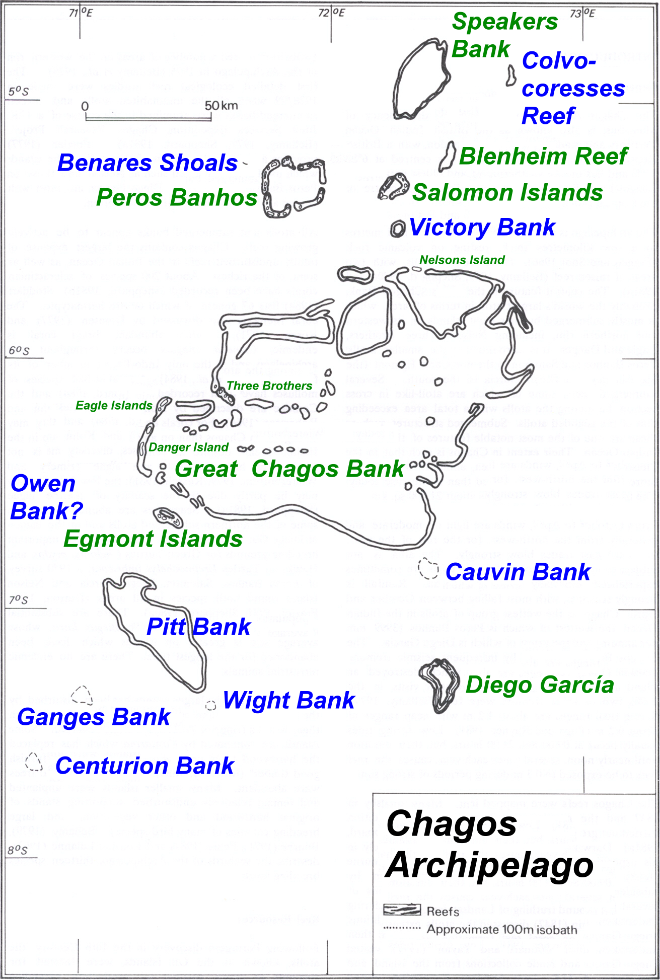
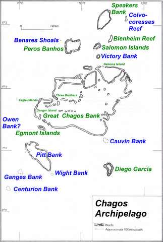
Deutsch: Karte des Chagos-Archipels im Indischen Ozean.
English: Map of Chagos-Archipelago in the Indian Ocean. |
| 日期 | not specified |
| 来源 | taken from http://www.coral.noaa.gov/Maps/chagos_large.jpg plus atoll and island names completed and rewritten |
| 作者 | NOAA, adapted by user Ratzer |
许可协议
本图像属于公有领域,因该作品最初来自于美国国家海洋和大气管理局职员的职务作品。
|
原始上传日志
| date/time | username | Dimensions | File Size | edit summary |
|---|---|---|---|---|
| 11:01, 30 July 2006 | Ratzer | 1311×1947 | 1.28 MB | base map from http://www.coral.noaa.gov/reef_maps/volume2/chagos_large.jpg, plus atoll and island names completed and rewritten |
文件历史
点击某个日期/时间查看对应时刻的文件。
| 日期/时间 | 缩略图 | 大小 | 用户 | 备注 | |
|---|---|---|---|---|---|
| 当前 | 2008年3月14日 (五) 08:43 | | 1,311 × 1,947(1.28 MB) | Telim tor | == Summary == {{Information |Description=Map of Chagos-Archipelago in the Indian Ocean. |Source=taken from http://www.coral.noaa.gov/reef_maps/volume2/chagos_large.jpg plus atoll and island names completed and rewritten |Date= |Author=NOAA |Permission= |o |
文件用途
没有页面链接到本图像。
全域文件用途
以下其他wiki使用此文件:
- af.wikipedia.org上的用途
- ar.wikipedia.org上的用途
- ast.wikipedia.org上的用途
- be-tarask.wikipedia.org上的用途
- ceb.wikipedia.org上的用途
- cs.wikipedia.org上的用途
- da.wikipedia.org上的用途
- de.wikipedia.org上的用途
- en.wikipedia.org上的用途
- eo.wikipedia.org上的用途
- es.wikipedia.org上的用途
- fa.wikipedia.org上的用途
- fi.wikipedia.org上的用途
- fr.wikipedia.org上的用途
- gl.wikipedia.org上的用途
- hr.wikipedia.org上的用途
- io.wikipedia.org上的用途
- ja.wikipedia.org上的用途
- ka.wikipedia.org上的用途
- lt.wikipedia.org上的用途
- nl.wikipedia.org上的用途
- ro.wikipedia.org上的用途
- ru.wikipedia.org上的用途
- ta.wikipedia.org上的用途
- tr.wikipedia.org上的用途
- uk.wikipedia.org上的用途
查看本文件的更多全域用途。