File:Chernobyl radiation map 1996.svg

此SVG文件的PNG预览的大小:568 × 600像素。 其他分辨率:227 × 240像素 | 455 × 480像素 | 727 × 768像素 | 970 × 1,024像素 | 1,940 × 2,048像素 | 1,398 × 1,476像素。
原始文件 (SVG文件,尺寸为1,398 × 1,476像素,文件大小:416 KB)
| 描述 |
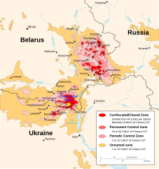
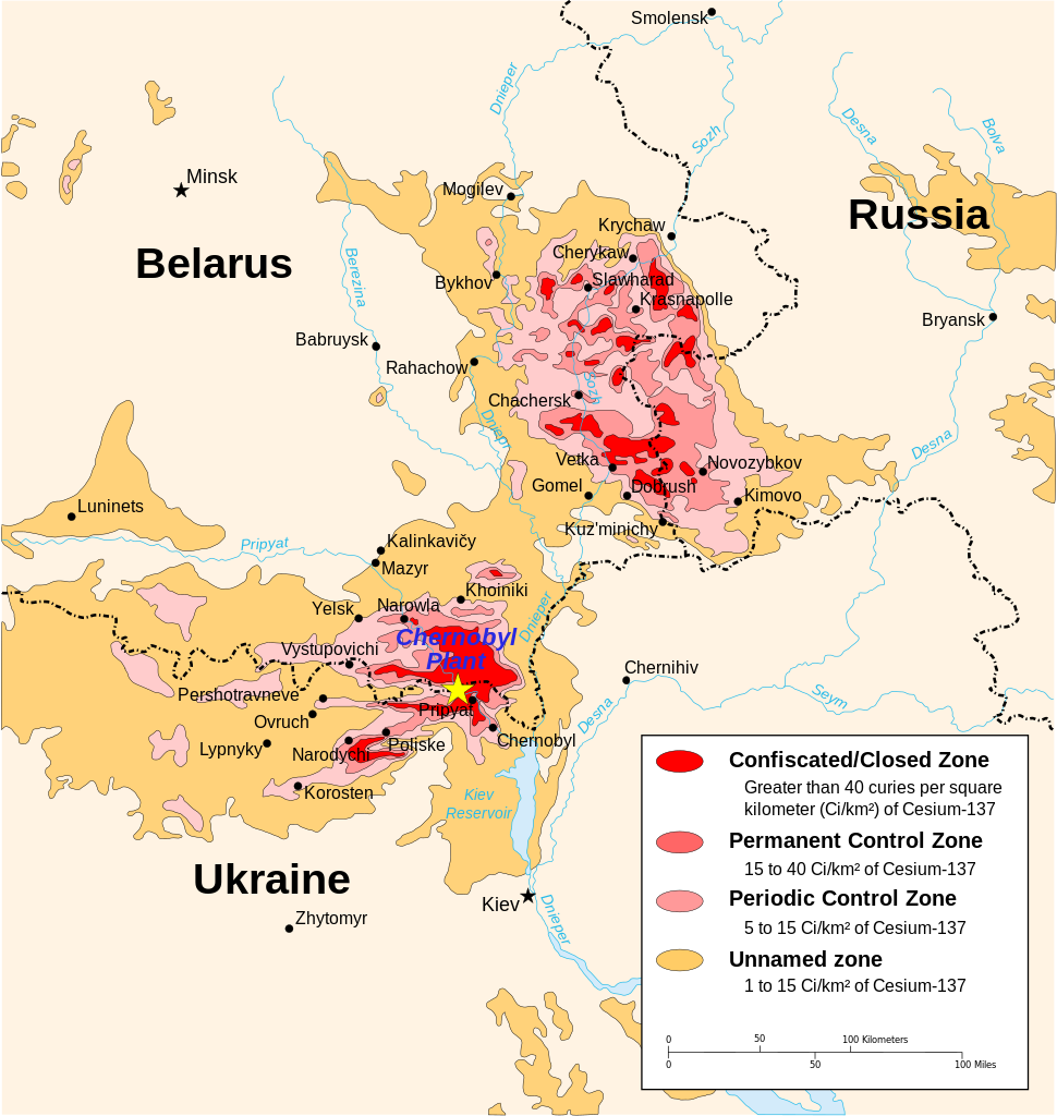
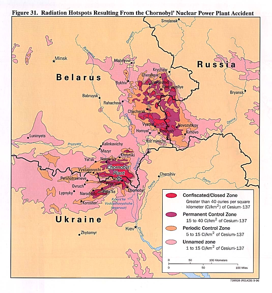
English: Chernobyl radiation map from CIA handbook, svg'd by User:Sting, and re-anglified by me (to the same strange names used in the original). |
| 来源 | http://www.lib.utexas.edu/maps/belarus.html, specifically http://www.lib.utexas.edu/maps/commonwealth/chornobyl_radiation96.jpg and File:Tchernobyl_radiation_1996.svg for the vector version |
| 作者 | CIA Factbook, Sting (vectorisation), MTruch (English translation), Makeemlighter (English translation) |
| 授权 (二次使用本文件) |
本文件采用知识共享署名-相同方式共享 2.5 通用许可协议授权。
|
| 其他版本 |
此文件衍生的作品: []
|


.svg)


|
文件历史
点击某个日期/时间查看对应时刻的文件。
| 日期/时间 | 缩略图 | 大小 | 用户 | 备注 | |
|---|---|---|---|---|---|
| 当前 | 2011年3月22日 (二) 19:48 | | 1,398 × 1,476(416 KB) | Makeemlighter | Remove black outline; fix trailing spaces. |
| 2011年3月18日 (五) 23:27 |  | 1,398 × 1,476(416 KB) | Makeemlighter | Completed English translation. | |
| 2009年4月29日 (三) 03:58 |  | 1,398 × 1,476(418 KB) | 84user | Neither Firefox nor Opera would render town circles in previous version, so I opened it in InkScape, selected town "layer", minimally moved one node and saved. | |
| 2007年8月25日 (六) 22:29 |  | 1,398 × 1,476(418 KB) | Mtruch | {{Information |Description=Chernobyl radiation map from CIA handbook, svg'd by User:Sting, and re-anglified by me (to the same strange names used in the original). |Source= |Date= |Author= |Permission= |other_versions=[[Image:Chornobyl radiation map |
文件用途
全域文件用途
以下其他wiki使用此文件:
- als.wikipedia.org上的用途
- bg.wikipedia.org上的用途
- bn.wikipedia.org上的用途
- ca.wikipedia.org上的用途
- ckb.wikipedia.org上的用途
- cs.wikipedia.org上的用途
- da.wikipedia.org上的用途
- en.wikipedia.org上的用途
- Chernobyl exclusion zone
- User talk:Mtruch
- Soviet atomic bomb project
- Talk:Chernobyl exclusion zone
- Portal:Ukraine
- Portal:Ukraine/Featured picture
- User:Sashazlv/Try
- Chernobyl disaster
- Effects of the Chernobyl disaster
- Nuclear safety and security
- User talk:Sting
- User talk:Makeemlighter
- Red Forest
- Wikipedia:WikiProject Ukraine
- Radioecology
- Portal:Maps/Maps/Thematic
- Environmental impact of nuclear power
- Wikipedia:Featured pictures/Diagrams, drawings, and maps/Maps
- Nuclear power debate
- Portal:Maps/Maps/Thematic/16
- Krupki
- Wikipedia:Reference desk/Archives/Computing/2010 September 16
- User talk:Makeemlighter/Archive 2
- Wikipedia:Featured pictures thumbs/27
- Wikipedia:Featured picture candidates/March-2011
- Wikipedia:Featured picture candidates/Chernobyl radiation map 1996
- Wikipedia:Wikipedia Signpost/2011-03-28/Features and admins
- Nuclear energy policy of the United States
- User talk:Nergaal/Archive 6
- Radiation-induced cancer
- Talk:Chernobyl disaster/Archive 10
- Wikipedia:WikiProject Russia/Recognized content
- Template:POTD/2013-04-26
- Wikipedia:Picture of the day/April 2013
- Wikipedia:Main Page history/2013 April 26
- Nuclear labor issues
- Polesie State Radioecological Reserve
- User talk:Nergaal/Archive 8
- User:Kazkaskazkasako/Books/Physical sciences
查看本文件的更多全域用途。