File:Chesapeake and Delaware Canal eastern entrance.jpg

本预览的尺寸:800 × 527像素。 其他分辨率:320 × 211像素 | 640 × 422像素 | 1,024 × 674像素 | 1,500 × 988像素。
原始文件 (1,500 × 988像素,文件大小:527 KB,MIME类型:image/jpeg)
| 描述 |
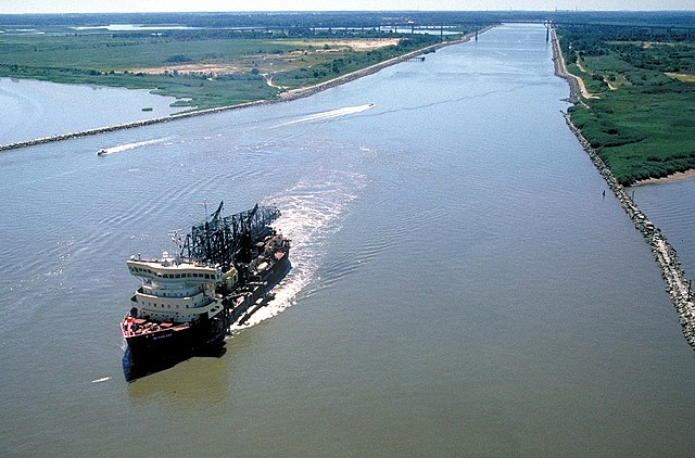
English: The eastern entrance to the Chesapeake & Delaware Canal at Reedy Point, Delaware. Fort Dupont State park is at the right. The Reedy Point Bridge, carrying Delaware State Route 9, is visible in the distance. The U.S. Army Corps of Engineers hopper dredge McFarland is exiting the channel. View is to the east. The channel entrance is located on the Delaware River in New Castle County, Delaware, USA.
|
|||
| 日期 | not specified or unknown | |||
| 来源 |
U.S. Army Corps of Engineers Digital Visual Library Image page Image description page Digital Visual Library home page |
|||
| 作者 | Anthony Bley, U.S. Army Corps of Engineers | |||
| 授权 (二次使用本文件) |
|
|||
| 图中地点 | Delaware River, New Castle County, Delaware, USA |
| 相机位置 | | 在以下服务上查看本图像和附近其他图像: OpenStreetMap |
|---|
文件历史
点击某个日期/时间查看对应时刻的文件。
| 日期/时间 | 缩略图 | 大小 | 用户 | 备注 | |
|---|---|---|---|---|---|
| 当前 | 2007年4月8日 (日) 02:46 | | 1,500 × 988(527 KB) | DanMS | {{Information | Description = {{en|The eastern entrance to the Chesapeake & Delaware Canal at Reedy Point, Delaware. Fort Dupont State park is at the right. The Reedy Point Bridge, carrying Delaware State Route 9, is visible in the distance. The U. |
文件用途
以下页面使用本文件:
全域文件用途
以下其他wiki使用此文件:
- de.wikipedia.org上的用途
- en.wikipedia.org上的用途
- es.wikipedia.org上的用途
- fr.wikipedia.org上的用途
- no.wikipedia.org上的用途
- vi.wikipedia.org上的用途
- www.wikidata.org上的用途