原始文件(705 × 705像素,文件大小:135 KB,MIME类型:image/png


摘要

此locator map图片可使用矢量图形重新创建为SVG文件。这具有很多好处;更多信息请参见共享资源:待清理媒体。如果存在此图片的SVG格式,请将其上传,然后将此模板替换为{{vector version available|新图片名称}}


建议您将SVG命名为“China map.svg”,这样在使用Vector version available(或Vva)模板时就不需要填写新图片名称参数。
描述
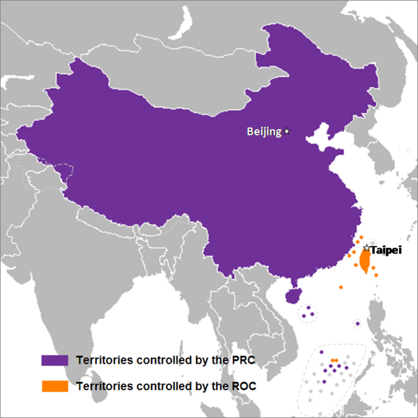
English: This is a map of the two states that officially use the name "China" in their names and depicts the actual "line of control" and not any claims that states often make. Key words: actual administration and actual maintaining of control of the territories.
中文(简体):这是一个关于两个都把“中华”用在自己的国名里的国家的地图,这个地图描绘了两国的实际“控制线”并跟两国通常声称的完全不是一回事。关键词:实际管辖和维持实际控制区域。
中文(繁體):這是一個關於兩個都把“中華”用在自己的國名裡的國家的地圖,這個地圖描繪了兩國的實際“控制線”並跟兩國通常聲稱的完全不是一回事。關鍵字:實際管轄和維持實際控制區域。
日期 2007年9月24日 (原始上传日期)
来源 本檔案是由Sreejithk2000使用CommonsHelper,從en.wikipedia轉移到維基共享資源。
作者 英语维基百科Nat

许可协议

英语维基百科Nat,本作品著作权人,特此采用以下许可协议发表本作品:
GNU head 已授权您依据自由软件基金会发行的无固定段落及封面封底文字(Invariant Sections, Front-Cover Texts, and Back-Cover Texts)的GNU自由文件许可协议1.2版或任意后续版本的条款,复制、传播和/或修改本文件。该协议的副本请见“GNU Free Documentation License”。
w:zh:知识共享
署名
本文件采用知识共享署名 3.0 未本地化版本许可协议授权。
您可以自由地:
  • 共享 – 复制、发行并传播本作品
  • 修改 – 改编作品
惟须遵守下列条件:
  • 署名 – 您必须对作品进行署名,提供授权条款的链接,并说明是否对原始内容进行了更改。您可以用任何合理的方式来署名,但不得以任何方式表明许可人认可您或您的使用。
您可以选择您需要的许可协议。

原始上传日志

原始描述頁面位於這裡。下列使用者名稱均來自en.wikipedia。
  • 2008-05-29 22:44 Shibo77 705×705× (136871 bytes)
  • 2008-05-29 21:59 Shibo77 705×705× (135686 bytes)
  • 2008-05-29 21:53 Shibo77 705×705× (132630 bytes) Reverted to version as of 00:46, 16 May 2008
  • 2008-05-29 08:51 Sontung007 556×537× (31782 bytes) Reverted to the neutral version to avoid disputes and ambiguity
  • 2008-05-16 00:46 Taktser 705×705× (132630 bytes)
  • 2008-05-16 00:44 Taktser 705×705× (132710 bytes)
  • 2008-05-03 20:22 T-1000 705×705× (115888 bytes) Reverted to version as of 22:31, 4 April 2008
  • 2008-04-08 17:10 Heavyrain2408 705×705× (129360 bytes) Chinese people use tricky word "administration" to mislead readers to believe these islands belonging to them. Please stop these kinds of actions.
  • 2008-04-04 22:31 Taktser 705×705× (115888 bytes) Reverted to version as of 20:02, 27 March 2008 (administration is clearly stated, not the question of sovereignty over these territories, Arunachal Pradesh is excluded; Aksai Chin, the Spratly islands and some of the Paracel islands are included)
  • 2008-03-30 05:36 Heavyrain2408 705×705× (129360 bytes) Constroversary parts should not be included. This could result readers think that these parts belong to China.
  • 2008-03-27 20:02 Taktser 705×705× (115888 bytes) Reverted to version as of 20:31, 10 March 2008 It's clearly stated as administration not sovereignty
  • 2008-03-21 21:11 Sontung007 705×705× (129360 bytes) the previous map wrongly included unresolved disputed islands
  • 2008-03-10 20:31 Taktser 705×705× (115888 bytes) Reverted to version as of 16:33, 16 November 2007
  • 2008-01-24 15:26 Sinoevils 705×705× (129360 bytes) This is the real China Map
  • 2008-01-24 15:24 Sinoevils 705×705× (129360 bytes) This is the real China Map
  • 2007-11-16 16:33 Nat 705×705× (115888 bytes)
  • 2007-11-06 18:53 Nat 556×537× (30702 bytes)
  • 2007-11-05 22:48 Nat 556×537× (33377 bytes)
  • 2007-10-28 07:25 Jjhcap99 556×537× (31782 bytes) Added country names.
  • 2007-10-19 22:35 Jerrch 556×537× (30043 bytes) Capitalized the capitals
  • 2007-10-16 22:23 Nat 556×537× (30403 bytes) Reverted to version as of 19:37, 9 October 2007
  • 2007-10-16 20:34 Jerrch 556×537× (30411 bytes) Reverted to version as of 19:56, 29 September 2007
  • 2007-10-15 13:05 Jjhcap99 556×537× (33989 bytes)
  • 2007-10-09 19:37 Nat 556×537× (30403 bytes) This is the work of {{user|Nat}}
  • 2007-10-09 19:32 Nat 556×537× (32238 bytes) This is the work of {{User7|Nat}}.
  • 2007-09-29 19:56 Jerrch 556×537× (30411 bytes) changed color a little bit to make it just a little more neutral.
  • 2007-09-24 23:16 Nat 556×537× (30343 bytes)
  • 2007-09-24 01:44 Nat 1127×1069× (958918 bytes)
註解
InfoField
該圖片含有註解:在維基媒體共享資源上查看註解

说明

添加一行文字以描述该文件所表现的内容
中国的地图

此文件中描述的项目

描繪內容

a3914e0e367e3234152db8229f8c9413a6fc7c3e

138,578 字节

705 像素

705 像素

文件历史

点击某个日期/时间查看对应时刻的文件。

日期/时间缩⁠略⁠图大小用户备注
当前2014年12月15日 (一) 06:142014年12月15日 (一) 06:14版本的缩略图705 × 705(135 KB)Shibo77..
2010年6月2日 (三) 10:262010年6月2日 (三) 10:26版本的缩略图705 × 705(134 KB)File Upload Bot (Magnus Manske) {{BotMoveToCommons|en.wikipedia|year={{subst:CURRENTYEAR}}|month={{subst:CURRENTMONTHNAME}}|day={{subst:CURRENTDAY}}}} {{Information |Description={{en|This is a map of the two states that officially use the name "China" in their names and depicts the act

全域文件用途

以下其他wiki使用此文件:

查看本文件的更多全域用途

元数据